Disruptive Blue Technology – At a Glance
- Although estimates vary widely, BlueTech market estimates are expected to grow rapidly in the near future. The Autonomous Ships market, estimated to be US$85.8 b in 2020 is expected to reach US$165.6 b by 2030 . The underwater drone market, valued at US$3.6b in 2019 is expected to reach US$7.5b by 2027 . Marine pharmaceuticals, estimated at US$26.5 b in 2020 is expected to reach US$ 48.1 b in 2027.
- Today, there are more than 300 floating solar installations worldwide. A report by Wood Mackenzie , a global research firm, estimates that global demand for floating solar power is expected to grow by 22 percent year-over-year on average from 2019 through 2024.
- Ocean waves could produce more than 2 million MW of electricity according to the US Department of Energy.
- Tidal power has the potential to create 3,000 gigawatts of energy worldwide , though estimates of how much of that energy is available for power generation by tidal barrages are between 120 and 400 GW, depending on the location and the potential for conversion.
Technology has been evolving at a rapid pace to help us rethink the promise and challenges of a Blue Economy. Entrepreneurs are creating new technological applications for monitoring and managing the freshwater, coastal, and ocean ecosystems of the Blue Economy. These are facilitated through work in academia, private sector, civil society organizations, governments, and other stakeholders and networks across them (e.g., industry clusters such as TMA BlueTech ). An overview of some of the innovations in the Blue economy have been reviewed by the OECD.
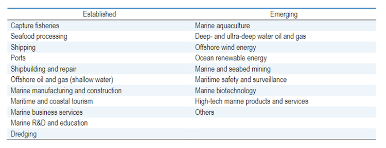
Established and emerging ocean-based industries, The Ocean Economy 2030, page 23
According to a report on Transforming the EU’s Blue Economy for a Sustainable Future , the blue economy encompasses a vast field of technologies and a wide range of operations that are essential to people’s daily lives. The use of technology in the Blue Economy ecosphere is a key element to identify and trade new opportunities and paradigms for ocean sustainability. This will help to reduce the gap in the utilization of ocean and coastal resources between developed and developing countries. For example, mobile technology allows better data on fish landings and fish stock health. The technology strengthens fishing sectors in poor and vulnerable countries and encourages sustainable and legal fishing practices, as well as local value creation. Blue Technology is based on ‘blue thinking’ – the belief that renewable resources and eco-sustainability offer a myriad of possibilities for social and economic growth and rethinking oceanic sectors that can help them with growth an poverty alleviation goals. The ocean holds unique and powerful solutions. Innovators are now unleashing them. The Blue Climate Initiative announced the three winners of their US$1 million Prize to support innovations that mitigate climate change through ocean-related strategies.
A few global examples of technology and innovation driving the blue economy are described in the following sections.
Overview of BlueTech
“BlueTech” is the application of technology to facilitate the sustainable development and management of the Blue Economy spectrum.
This is a key part of the innovation required to rethink the potential and challenges of the oceans, coasts, and large water bodies that comprise the Blue Economy.
There are many resources available to describe various aspects of BlueTech (e.g. NOAA,NASA, GEO Blue Planet, ESA TMA BlueTech , UN , World Bank, WEF, EU ).
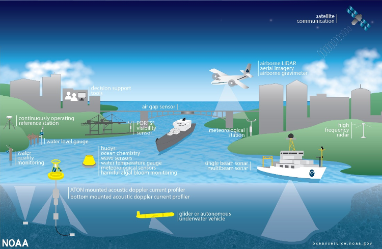
The lack of observations and data has historically been a major limitation for understanding the ocean and the impacts of human activities. The Internet of Things (IoT) phenomenon for the ocean is in its infancy . Thinking about an IoT for the ocean will still require new approaches to data communications and sensor location. Terrestrial systems can rely on satellite-based positioning systems and radio networks, whereas ocean systems often cannot. According to a Blue Paper , over the next decade, an IoT model will begin to become a reality.
The availability of powerful microprocessors that consume small amounts of energy will enable networks that transmit small, but information-rich messages (e.g. sensors that identify harmful algal bloom species on board and then transmit a simple presence/ absence message). It is also essential that smart sensor networks are compatible with different types of data access regimes, including open access. However, IoT sensors are also vulnerable to attack. While the security and privacy concerns that are relevant for smart sensors located in the home are less pressing in the ocean, the vulnerability of sensor networks could make large-scale manipulation of data inputs relatively easy. Governments, industry and researchers must work together to develop network architectures that overcome these concerns.
At the Second Global Session of the UN Science Policy Business Forum and UN Environmental Assembly in March 2019, unprecedented initiatives were launched to unite global efforts to leverage frontier technologies to monitor the state of the world environment. Several UN bodies have worked closely to bring out a report in 2020 that defines frontier technologies as new, innovative, and disruptive technologies. The report collates observations from the real-world deployment of key emerging technologies for building a global digital ecosystem for the planet. The report has concluded eight key emerging technologies in tackling climate change: artificial intelligence (AI), Internet of Things (IoT), 5G, clean energy technology, digital twins, robotics, Space 2.0 technologies, as well as digitalization and Big Data within cities and urban regions.
Emerging technologies have the capacity to “disrupt” the blue economy by helping countries leapfrog and scale impact when adopted effectively. These include “disruptive technologies” that are already helping rethink informatics for decision support, operational systems, and stakeholder interaction in “Blue Tech”. There is a strong need especially in the developing world to learn from emerging global good practices and risk management measures in a rapidly changing technological environment. Indeed, the transformative potential of disruptive innovations in the blue technology sector is so significant that public and private sector actors are joining forces to build a digital ecosystem for the planet.
Bluetech describes ocean and ocean-adjacent technology that drives environmental, social, and economic sustainability. Companies and governments use bluetech to tackle a wide range of challenges – from climate change, coastal erosion, and ocean plastic pollution to shipping logistics and supply chain management. What does that look like in practice? Autonomous underground gliders , tidal energy generators , macro-algae biofuels , ropeless lobster traps, and app-based marketplaces are a few examples of recent bluetech innovations.
Coastal municipalities can build an ecosystem of smart devices and cloud interactions that enable digital services revenue, while creating digital experiences for citizens and visitors. Emerging and disruptive digital technologies have the potential to enhance climate resilience of critical infrastructure, by providing rapid and accurate assessment of asset condition and support decision-making and adaptation. A recent publication shows how available roadmaps, tools and emerging digital technologies, e.g. IoT, digital twins, point clouds, Artificial Intelligence, Building Information Modeling, can enhance the climate resilience of critical infrastructure. Further, the paper shows how infrastructure resilience can be represented through four distinct phases of the infrastructure life-cycle—planning and preparation before the hazard events, absorption and response during and immediately after the hazard occurrence, followed by recovery and adaptation to novel stressors.
The emergence and adoption of digital technology leads to a multitude of benefits, but it also introduces risks , as they increase vulnerability to cyber-attacks that in some cases may escalate cyberwarfare, leading to security and citizens’ privacy risks and misinformation. They could also themselves be susceptible to the challenges of climate risks. These technologies remain heavily reliant on the power supply and the interdependencies between their operators. Additionally, there is an involved tension in human–machine interaction during decision-making . Also, the adoption of such technologies in developing economies might be slower depending on enabling policies and institutional capacity, exacerbating a digital divide. These may also lead to the accelerated obsolescence of traditional jobs. Yet, unlike physical infrastructure, digital technologies have the advantage of extensive scalability at very low costs. Thus, the automation and roll-out of digital technology will need to be accompanied with significant capacity development in terms of awareness of benefits and risks and how to best manage these risks while scaling implementation.
Blue Technologies holds great promise for established organizations as well as startups that are developing solutions that have a positive impact on our oceans.
The manufacturing of marine equipment and materials, such as machinery, valves, cables, sensors, ship materials, aquaculture supplies and so on. Global value added in marine equipment in 2010 was estimated to be USD 168 billion, with the biggest share in Asia. Asia accounted for over three-quarters of the global market, with China and Korea alone making up more than half. Based on data approximated from BALance Technology Consulting (2014) marine equipment provided 2.1 million full-time jobs in 2010.
Satellite Data
Sentinel-1 is the first satellite in the European Space Agency's and the European Commission's Copernicus satellite constellation. The mission is made up of two satellites, Sentinel-1A and Sentinel-1B ( currently inactive due to malfunction ), that orbit in the same orbital plane. Sentinel-1 is equipped with a C-band Synthetic Imaging Radar (SAR) capable of imaging down to 5 meters and covering an area of up to 400 kilometers. SAR satellites are not affected by cloud cover or lack of illumination and can collect data over a day or night, under all weather conditions. It is planned to acquire high-resolution images of coastal areas, and shipping channels, as well as vignettes of the global ocean.
The European Space Agency operates Sentinel-2 as part of the ESA Copernicus constellation. Twin optical high-resolution multispectral satellites flying in the same orbit but phased 180° apart are planned to have a 5-day revisit frequency at the Equator. Sentinel-2 carries an optical instrument payload that samples 13 bands where the spatial resolution ranges from 10 meters to 60 meters. Sentinel-2’s provides continuity of SPOT and Landsat-type image data by contributing to ongoing multispectral observations and are used for water quality mapping, maritime surveillance, and bathymetry mapping.
Sentinel-3 , operated by the European Space Agency, is part of the ESA Copernicus constellation. Twin low, optical resolution multispectral satellites that are 180 degrees apart. The repeat cycle is 27-day for the altimetry, with the Ocean Land Colour Instrument (OLCI) with global coverage of less than four days and the Sea and Land Surface Temperature Radiometer with worldwide coverage of less than two days. The satellite carries three main instruments: OLCI, which has 21 spectral bands where the spatial resolution ranges from 300 meters to 1,200 meters in reduced resolution; SLSTR, which has nine bands where the spatial resolution ranges from 0.5 KM to 1.0 KM; and SAR Radar Altimeter. Sentinel-3 imagery is used to map ocean color, sea-surface topography, sea surface temperature, and coastal water quality.
Copernicus 6, Mike Michael Freilich satellite , launched in 2020, with a twin satellite expected to be launched five years later, is part of the ESA Copernicus constellation. Sentinel 6 is equipped with an altimeter that will provide near real-time information on sea surface heights, significant wave heights, and other outputs that will support operational oceanography and climate modeling. The satellite will be in the same orbit as the JASON-3 satellite, which will extend the long-term altimetry data from 1992.
Moderate Resolution Imaging Spectroradiometer (MODIS) is a low spatial resolution instrument that ranges from 250 meters to 1 km abroad the Terra and Aqua satellite. MODIS has 36 spectral bands and images of the earth every 1- 2 days. The Terra satellite has a descending orbit from north to south and passes over the equator in the morning. In contrast, the Aqua satellite has an ascending orbit (south to north) and passes the equator in the afternoon. MODIS has been used for water quality monitoring, sea surface temperature and sea ice.
In-Situ Observations
The Argo system is a global ocean monitoring system to study ocean physics, chemistry and biology, and climate change interactions. Argo makes a real-time observation by diving to 2,000 meters and developing a depth, temperature, and salinity water column profile. Once the system reaches the surface, the data is transmitted to the shore via satellite. There are approximately 3900 floats in operation. In 2016, the Biogeochemical BGC-Argo was launched to obtain biogeochemical data where they float collected information on oxygen concentration, nitrate concentration, pH, chlorophyll-a, suspended particles, and downwelling irradiance.
Researchers use Animal Borne Ocean Sensors (AniBOS), which place sensors on marine creatures to obtain oceanographic data to expand the overall data or hard-to-reach locations. Data from animals provides physical and biological information at the same scale and resolution at which the animal migrates. Researchers have applied animal sensors in the arctic , tropical ocean and coastal environment. Data is incorporated into the Global Ocean Observing System.
The Global Ocean Observing System (GOOS) , administered by the Intergovernmental Oceanographic Commission, was developed for sustained observation of essential oceanic variables. Various entities use the data to help make predictions about the ocean, climate, and protecting the ocean's health and its benefit.
Ocean Sustained Interdisciplinary Timeseries Environment observation System (OceanSITES), a GOOS component, consists of a global network of long-term deepwater reference stations that monitors dozens of variables in the water column in real-time from air-sea interactions to 5000 meters deep. Data is used for meteorology, physical oceanography, carbon cycle, ocean acidification, ecology, etc.
The Global Drifter Program is part of GOOS, which operates 1250 drifters at an array of 5° x 5°. Drifters are free-surface ocean buoys that collect information on ocean currents, sea surface temperature, pressure, and salinity. A drifter consists of a surface buoy and a weighted drogue, or sea anchor , that minimizes the impact of waves and wind on the ocean surface. Data is used for climate research and monitoring and short-term (seasonal to inter-annual) climate forecasts.
The Everyone Gliders Observatory (EGO) is to use gliders for ocean observations. Gliders can carry a range of sensors to help resolve temporal and spatial scales. Data is used to understand oceanic physical and biogeochemical variability .
Global Ocean Ship-based Hydrographic Investigations Program (GO-SHIP) coordinates a global network of hydrographic sections since ship-based surveys are the sole option for collecting high spatial and vertical resolution data. This type of survey is crucial for monitoring changes when the ocean depth exceeds 2 km deep. GO-SHIP can measure changes in the water column for heat, freshwater, carbon, oxygen, nutrients, and transient tracers inventories on a global scale with the accuracy required to measure those changes.