Forests are a critical habitat for biodiversity and also provide several other ecosystem services sustaining ecosystems and communities around the world.
Forests – At a Glance
-
Forests cover about 4 billion hectares or a third of the world’s land area .
-
Forests are home to 50% to 80% of land animals and plants .
-
The world may have 3 trillion trees (1.4 trillion in the tropics and subtropics, 0.7 trillion in boreal areas, and 0.6 trillion in temperate areas). About 15.3 billion trees may be chopped down each year on an area ranging from 6.6 to 19 million hectares of tree cover lost annually.
-
A single tree can sequester up to 150 kg of Carbon annually while growing.
-
About 25% of the medicines we use originate in rainforest plants, but only 1% of rainforest plants have been studies for medicinal properties!
-
About 40% of rainfall over land originates from plant evapotranspiration.
Data and Analytics
Earth Observation
JAXA (Forest and Non-Forest Mapping)
Global forest/non-forest map at 25-meter resolution (yearly from 2007-2018) are generated from the PALSAR-2/PALSAR instrument on the ALOS and ALOS-2 satellite, respectively. PALSAR and PALSAR-2 is L-band SAR data at 24 cm wavelength that can provide earth observation and penetrate through forest canopy regardless of cloud cover or day and night conditions. Forested and non-forested areas are classified based on climate dependent thresholds where strong HV and weak HV backscatter coefficients represent forested and non-forested areas, respectively.
Planet
Tropical rainforests are disappearing at an alarming rate since there is a lack of freely available high-resolution imagery data to spotlight the occurring changes. Through the Norway International Climate and Forest Initiative, the Government of Norway contracted Planet Labs, Airbus, and Kongsberg Satellite Services (KSAT) to provide freely available imagery and technical support to everyone. Airbus will release their SPOT-5 imagery, which goes back to 2002; Planet will release updated imagery on a monthly timescale, and KSAT will provide technical support. The imagery allows for viewing of development and deforestation that has occurred over several years. The data would be useful for companies to monitor sustainable production of raw material from their suppliers and allow indigenous communities and NGOs to understand or plan for the changes occurring in their environment. Data can be accessed from Global Forest Watch or Planet Explorer.
Hansen Data and Global Forest Watch
Global forest loss has been a matter of concern for the scientific community and leaders all over the world, because of the critic role forests plays against global warming, loss of biodiversity, disasters and many other global problems. To create a reliable quantification of global forest change, a team of scientist leaded by Matthew C. Hansen from the Department of Geographical Sciences, University of Maryland, conducted a study using Earth Observation satellite data to map global forest loss and gain from 2000 to 2012 at a spatial resolution of 30 meters using Google Earth Engine’s cloud computing capacity. That has resulted in a worldwide dataset that measures areas of tree cover across all global land. It has been updated annually and its latest version 1.7 includes loss data up to 2019. The analysis is based on Landsat data, defining tree cover as “all vegetation greater than 5 meters in height” and Forest loss as a “standard replacement disturbance or the complete removal of tree cover canopy at the Landsat pixel scale”. This is showcased on WRI’s Global Forest Watch application along with many other relevant data services.
Global Forest Watch has also included a new system for automatically generated alerts (GLAD Alerts) that spotlight ongoing tropical deforestation in a new online platform
Mapping Forest Height with GEDI
GEDI (Global Ecosystem Dynamics Investigation), pronounced Jedi from Star Wars, is a LIDAR instrument with three lasers attached to the International Space Staton to map the forest's 3D structure, canopy height, and distribution of branches and leaves. Vertical canopy measurements are based on waveform LIDAR, where changes in the amplitude signal measurement time are related to the amount of canopy material at that height. Information on forest biomass allows scientists to determine the impact of deforestation by determining how much carbon dioxide will be released into the environment. The data also provides scientists to measure biodiversity over time by mapping the habitat of plants and animals. GEDI collects 6 million measurements every day, and over the 24 months projected lifetime, it will take 10 billion observations.
Counting Trees in the Western African Sahara and Sahel
NASA scientists estimated biomass as part of a carbon estimate in the dryland regions of sub-Sahara Africa and the Sahel region by counting the number of trees and shrubs outside forested areas. Using a supercomputer, machine learning algorithm, and high-resolution imagery Using supercomputers, high-resolution imagery, and machine learning, they counted 1.8 billion trees from 1.3 million square miles from coast to coast outside of forested areas. Analysis of this type took months or years instead of a few weeks.
Aerial Surveys
Carnegie Airborne Observatory’s is using a high-resolution imaging instrumentation- AToMS to collect hyperspectral data, enabling mapping of various species, land and soils in rainforests using chemical variations, carbon stocks in Peru, archaeologic sites in Central America, very high-resolution terrain details in forests, changes in forests in steep terrains in Amazon.
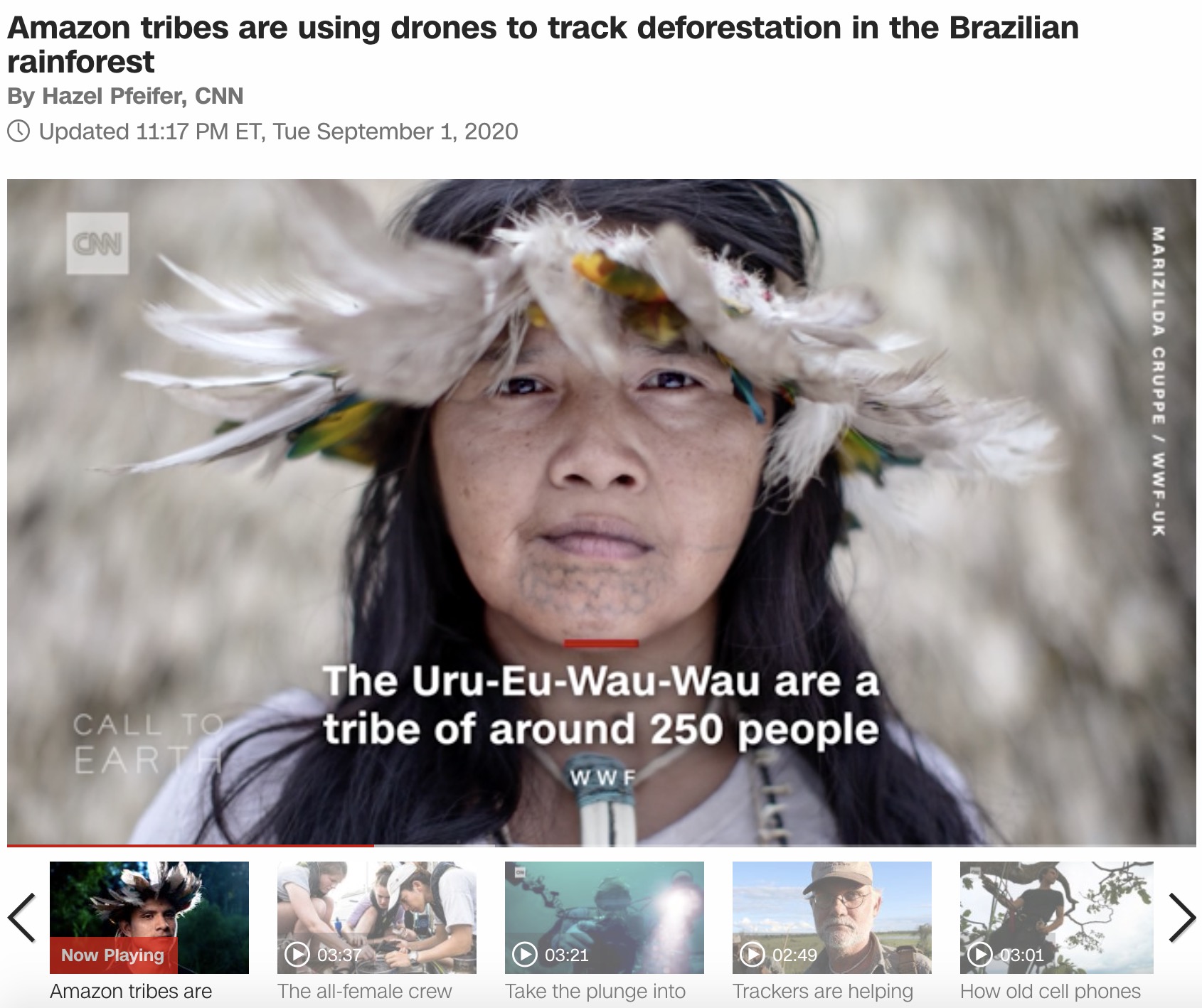
Drones - Rondonia
Illegal forest fires in the Amazon threatens the way of life of the people who depend on it for their livelihoods, the WWF and Kaninde Ethno-Environmental Defense Association have trained 6 indigenous communities in the Rondonia State, of western brazil on how to use drones for capturing high resolution images, video and GPS mapping data which can be used as evidence for reporting illegal activities, monitoring a much wider area than the communities previously could and helping to prevent dangerous confrontations with illegal loggers and land-grabbers.
Monitoring Deforestation via Drones
In-Situ data
There are many emerging technology solutions that use in-situ systems to help contribute to big data to better manage forests and reduce illegal logging.
Ant Forest
Ant Forest, developed by the Ant Group, is a social networking game that uses the Alipay online payment system to promote low carbon activities daily. The app was launched in August 2016 as a charity feature, but social competition between friends has encouraged its uptake. Today, over 100 million trees have been planted from the 500 million users. Users earn green energy for choosing public transportation, electronic invoices, and using less plastic, etc. Once enough green energy is earned to plant a virtual tree, Ant Financial will plant an actual tree in China's remote parts. Users can monitor their planted trees in the app via satellite and surveillance. Although Ant Forest is specifically for China, the Ant Group has launched a similar program, GCash, with a Philippine affiliate to promote deforestation awareness.
The global forest watch ’s, Forest Watch app , enable uses to be able to access the dynamic online forest monitoring and alert systems of the GFW offline and while on the field from a smart phone. Users can set up locations to monitor, download deforestation and fire alerts, allowing exploring and reporting on findings without the need for internet connectivity. Users of the app range from governments and civil societies to journalists.
CyberTracker Conservation, a South African non-profit company developed a mobile application to equip non-literate trackers in South Africa with technology to allow them to track and record wildlife data. The technology allowed trackers to get jobs in ecotourism, anti-poaching, wildlife monitoring and scientific research. Today, CyberTracker continues to offer free software for icon-based data collection, analysis and visualization on Smartphones for any type of GPS field data collection and allows indigenous knowledge to be combined with advanced computer and satellite technology. CyberTracker has also already been used for monitoring forests for REDD by communities. Key features include easy icon interface, moving map functionality, built-in camera and thresholds of acceptable change in the environment can be set so that users are alerted if those thresholds have potential to be exceeded.
Many open source tools have become popular in recent years, including Open Data Kits (ODK, Kobo Toolbox) to collect in-situ data and undertake spatial surveys.
Commercial systems are also very popular. ArcGIS Collector extends the ArcGIS platform to the field by allowing the user to create and share maps using ArcGIS and then collect data to add to the maps, including point, line and area features and images and videos, using mobile devices (smartphones or tablets). ArcGIS Collector can work offline, and users may sync work when a connection is available. The software also features predefined industry templates with which to collect data. Data moves seamlessly from the mobile device to the tablet (ArcPAD) and to the desktop (ArcGIS), and editor tracking shows when features in a shared map were last edited and by whom. To use maps in ArcGIS Collector, user must have an ArcGIS organizational account.
Creating Planet Intelligence
Dutch startup Overstory is an AI-based forest intelligence platform for automated satellite data analytics of tree and land assets, urban green spaces, and vegetation. It is using machine learning to help interpret satellite imagery and climate data. The platform helps in identifying risk areas, predicting consequences of planting activities, mitigating wildfires and power outages.
Many of these information tools can help improve manage forests better – including forest fires that are critical in places such as Africa and Brazil.
Forest Management
Forests: There’s an App for That!
Ant Forest, developed by the Ant Financial Services Group, is a social networking game that uses the Alipay online payment system to promote low carbon activities daily. The app was launched in August 2016 as a charity feature, but social competition between friends has encouraged its uptake. Today, over 100 million trees have been planted from the 500 million users. Users earn green energy for choosing public transportation, electronic invoices, and using less plastic, etc. Once enough green energy is earned to plant a virtual tree, Ant Financial will plant an actual tree in China's remote parts. Users can monitor their planted trees in the app via satellite and surveillance. The Ant Forest App recently won the UN Champions of the Earth award . Although Ant Forest is specifically for China, the Ant Group has launched a similar program, GCash, with a Philippine affiliate to promote deforestation awareness.
Listening to a Tree Fall
Rainforest Connection (RFCx) , a San Francisco-based nonprofit organization transforms recycled Android cell phones into autonomous, solar-powered listening devices that monitor and pinpoint chainsaw activity resulting from illegal deforestation from a considerable distance. The devices continuously record and screen ambient sounds in the rainforest, sounding an alarm to relevant authorities when the ambient sounds match the sound-signature of a chainsaw or a motorcycle. Alerts are sent using existing cell networks, which are present in many remote areas, and the phones are powered using solar energy. Each phone covers an area with a radius of roughly one square mile. Rainforest Connection has so far installed such phones in Indonesia, Cameroon, Brazil, Ecuador and Peru.
The Rainforest Alliance is an international non-profit organization and its main work is the provision of an environmental certification on sustainable forestry, agriculture and tourism. They collaborate with all kind of partners (from smallholder farmers and forest communities to corporate and civil societies) to support frontline communities in responding to the most urgent challenges: Climate change, deforestation, and rural poverty. They focus on leveraging market forces to make a positive impact on the forest economies along entire supply chains.
The process starts from the very beginning of the economic activity, working with local partners to design and implement creative strategies to protect vulnerable landscapes and restore degraded ones. The certification focuses on enhancing monitoring through standards and assurance protocols. This is supported by improved data analytics to assess the specific needs of a particular community over the long term.
The ultimate objective that this certification aims to achieve is the implementation of long-term conservation techniques that focus on rural enterprise development. To achieve this the Rainforest Alliance team, collaborate with its partner communities to design curated initiatives that include training, technical assistance, sustainable financing, public-private partnerships and market linkages in addition to certification.
Drone-planted Mangroves
Drones are being used to efficiently reforest mangroves, the drones initially map out the land to be planted, while mapping detailed data about the topology and soil quality are also capture. An algorithm is used to determine the best location and species of trees to plant. A second group of drones are then flown closer to the grown, using the amp to sow plant seeds. The seeds are kept in nutrient field seed pods, the pods are quickly fired in the ground, to allow for penetration into the soil… In Myanmar, this technology is being used, by BioCarbon Engineering (now Dendra) and Worldview International Foundation , in the Irrawaddy river area to replant mangroves, 100 ,000 seeds are planted daily with six drones. 10 times faster and half the cost of planting manually.
Trees are an essential component to keep our environment clean. According to a Nature study, around 15 billion trees are cut every year. Many projects of afforestation are underway using automated tree planting using drones in India and Myanmar . To scale up ecosystem restoration efforts Research institutes such as the Indian Institute of Science Bangalore, are planting trees using drones to reforest large areas of land. The use of Unmanned Autonomous Vehicles (UAVs), commonly known as drones, makes it possible to have a more precise image of the area to be seeded and, this technology allows results monitoring to ensure trees are growing in optimal conditions. There are startups such as Oxford based Dendra using a combination of drone technology and artificial intelligence, to restore former mine and degraded farmland in Australia and Mangrove reforestation in Myanmar. Drones are used to survey the sites to capture data on the state of the land, that is combined with data from ecologists. Artificial intelligence is then used to analyze data to identify the types of plants and animals on the site and the size of the land. The seeds are specialized to ensure optimum growth, the drones further allow access to difficult areas in less time than using traditional methods. Two operators working with 10 drones can theoretically plant 400,000 trees in a day and in Myanmar the aim is to replant 1 billion trees.
Korea Forest Services
Korea has had a long history of greening the country as part of a development paradigm choice it made in a post-war context to create jobs and invest for the longer-term sustainability of its natural resources.
Currently, Korea is a part of the Bonn Challenge as a country which has been successful in reforestation after the 2nd World War. The Bonn Challenge is the world’s largest collaborative restoration initiative launched by the International Union for Conservation of Nature (IUCN) and the Germany government with the goal to bring 150 million hectares of the world’s deforested and degraded land into restoration by 2020, and 350 million hectares by 2030.Commemorating the first milestone year of global forest landscape restoration efforts for restoration of 150 million hectares by 2020, Korea joined 24-hour Restore Our Future Campaign The video shows Korea’s successful forest restoration experience and its future forest policies.
Korea is now exploring new services leveraging the calming influence of forests.
SMART Forest Management
The Korea Forest Service (KFS), as managers of Korea’s forest resources, are combining a variety of technologies in forest planning and management, forest recreation and in response to forest disasters.
These include:
Drones for quickly and accurately undertaking missions in severe or rugged areas. Drones are fitted thermal imaging cameras, and LiDAR, and used for detection of forest fires, assessing damage due to landslides, hillside forest surveillance especially for inaccessible areas, and supporting mountain management.
Internet of Things (IoT): for real-time information transmission and response. Some uses of IoT are for SMART forest nursery management, real time mapping of forest fires and recreation forest facility management.
Artificial intelligence (AI): used for automatic detection of forest diseases and pests in combination with drones.
Robots: used for wood processing with equipment capable of customized production.
Virtual reality (VR): used for forest fire disaster simulation and in forest recreation.
Integrated Forest Disaster Management System
Korea Forest Service’s Control Office
South Korea is one of a few countries with a successful history of forest rehabilitation following World War II. In Korea, sustainable forest management is one of the most important issues as forest covers 63.4% of the land (forest area: 6.36 mil. Ha) and responding to forest disaster is also a big part of forestry as the weather is getting drier and hotter due to climate change. To this end, digital technology has played a key role in solving forestry challenges through remote sensing, early warning and detection and initial attack by using high-tech ICT system. Forest Disaster Integrated Management System (FDMS) is a cloud-based information delivery system, using digital geo-spatial technology, which is a good example of how the internet and well-designed software tools can be applied to respond to forestry challenges. The system has been used in three key areas of forest management: forest fire, landslide and forest disease. The system is managed by a disaster control room in the Korea Forest Service (KFS) which disseminates forest disaster related information to citizens, forest disaster officers in government, municipalities and disaster control centers in each relevant entity through an information transfer system using ICT.
Conceptual Diagram of Integrated Forest Disaster Management System
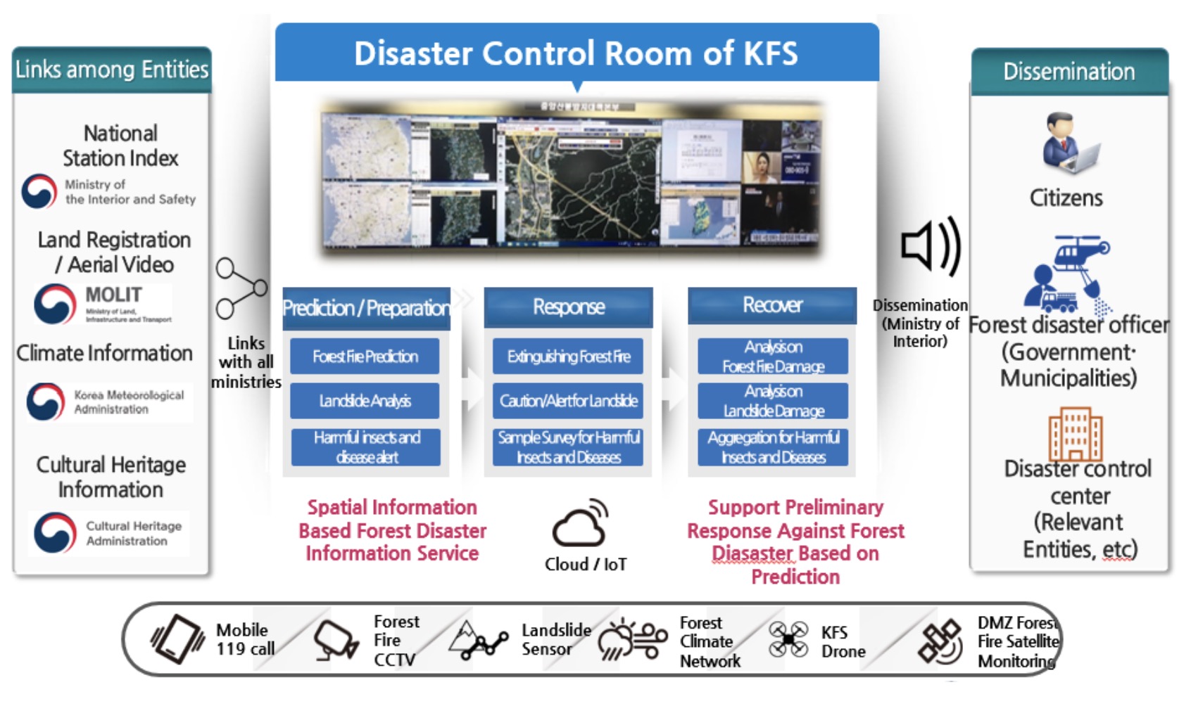
Source: Korea Forest Service presentation
Real-time data collection and analysis
Korea Forest Service (KFS) observes weather on the top of the mountains which is much different from the weather on the flatland. To do this, the mountain weather forecast tower was established for real-time forecasting and to minimize damages from forest disaster. It observes the mountain weather and transfers data to a control room in KFS. Based on the real-time data, KFS conducts data analysis and established a strategy and action plan responding to forest disaster.
Analyze real-time data and forest fire index from a forecast tower control room and provide results to municipalities.
15,000 fire watchers who are hired during the fire season, patrol vulnerable areas and report occurrences of fire. Using GPS and KFS monitors the current location of fire watchers for every 10 minutes by using GPS terminals of 15,000 observers to enhance rapid response against forest fire for anti-forest fire campaign and observation.
1,448 unmanned surveillance cameras are installed in the whole mountain area.
Based on real-time data from forecast towers, the Korea Forest Research Institute (KFRI) under KFS conducts field verification and tank model analysis which analyze past landslide occurrence history by region. The amount of rainwater in the soil is calculated by the soil function index based on the results. KFS distributes the information on vulnerable locations for landslides, at city, county and district level. Also, warning messages are sent through mobile phones to the public.
Mountain Weather Forecast Tower
Smartphone Applications
Using MMS (Multimedia Messaging Service), VMS (Voice Mailing System) and smartphone applications enables rapid information sharing with relevant entities and the public and contributes to minimize damage from disaster through early response and real-time alert. It also improves communication with the public by promoting citizen participation, e.g., getting a report of fire in the mountains from the public. Smartphone application users can access integrated information such as forest fire reports, forest damage reports, harmful insects and diseases, etc. Also, users can search the location of Pine wilt disease and thematic maps of the KFS such as landslide prediction maps, forest road network maps, etc. and measure the scale of damaged area using GPS tracking and map dragging.
KFS runs the application which provides integrated forest information including tracking course, real-time mountain weather and disaster. It provides field support services like mobile search for forest fire, chat room, field reporting in real-time to people who extinguish fire in the field for rapid situation report. Also, it enables citizen participation as the public can make a report of forest fire by taking a picture through the application and facilitate early response because the pictures have GPS information. Landslide prediction information and real-time alerts are also provided based on where users are located (by city, county, district) using the smartphone’s GPS.
Drones
A Drone Video Sharing System integrates each video data collected from KFS(HQ), KFS local offices and local government offices, and monitors real-time video data to check the scale of damaged area, prevent the dissemination of damage by forecasting the infected trees and checking the vulnerable area for landslide and damaged forests. It captures the panoramic picture of forest project sites to support forest fire, landslide and forest projects with ortho photos and panoramic pictures captured by drones.
Drones have been used in combatting forest fires for mapping and detecting hotspots. They can be fitted with both regular and thermal imaging cameras and can fly into areas that manned aircraft are unable to access – including at night when winds die down and fires become theoretically easier to control. It detects location of landslides and scale of damage and supports emergency rehabilitation by providing real-time video data. It automatically develops algorithms for distribution of vulnerable locations of landslides. It detects forest diseases such as Pine Wilt disease and monitors from the stage of disease outbreak to recover(logging) through time-series filming, and it is used for inspection and quantity estimation in forest industry. It detects reflexibility of leaves depending on the degree of damage from disease by using Multi-Spectral Cameras (MSC) equipped with special purpose sensors and figures out discoloration and wilting. Drones can be used not only to detect wildfires, but also to suppress wildfires by dropping extinguishing balls in the air.
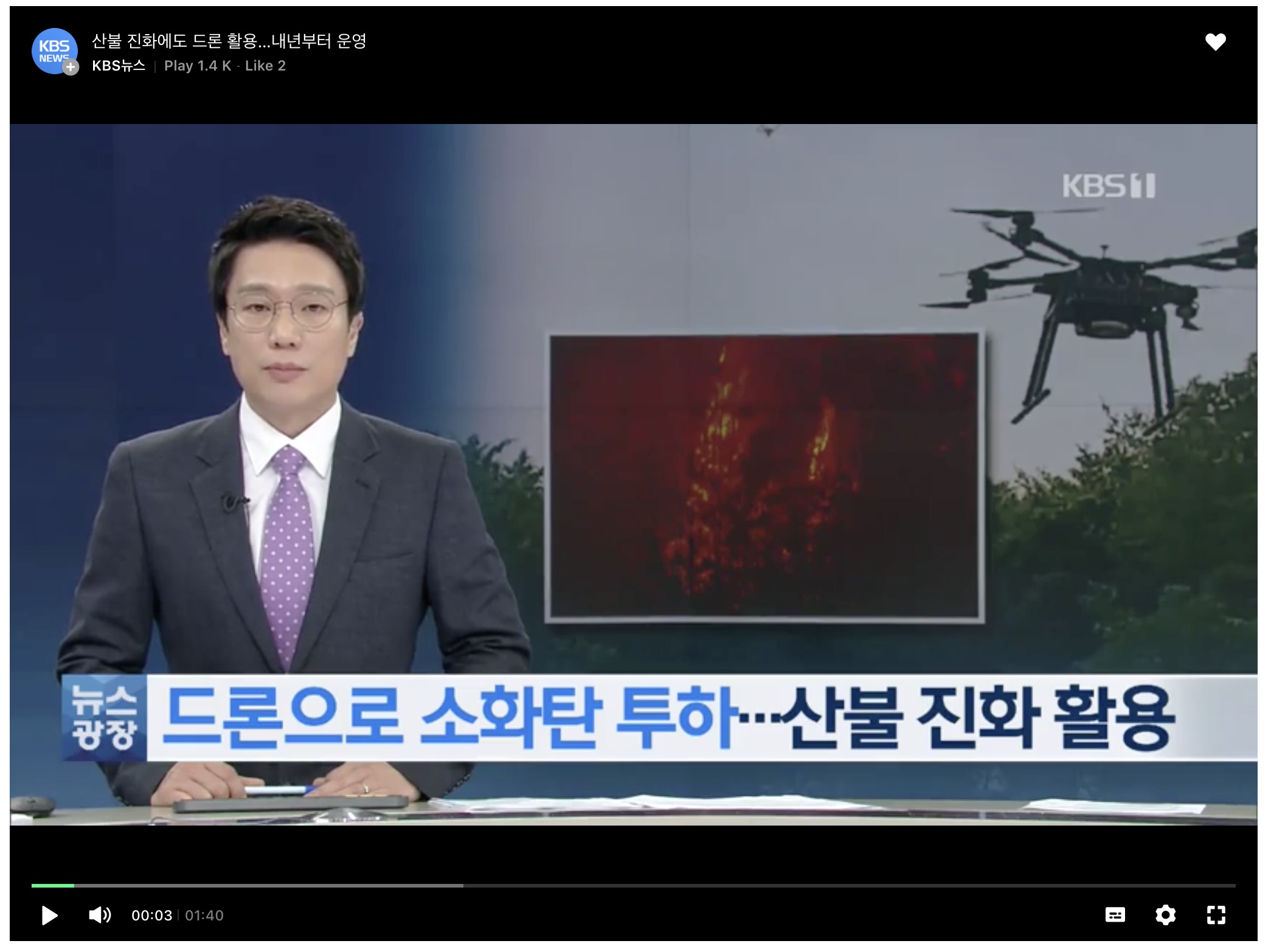
Drone extinguishing a forest fire
NFC (Near Field Communication) prediction
NFC e-forecasting boxes are set in key areas in pine trees and it forecasts as well as provides time and path data on the map in the control room to set early response systems against insect damage through NFC forecasting.
Wearable Robot for extinguishing forest fire
Wearable robots were promoted by the Korea Forest Service as a research and development project for the practical use of forest science and technology, and it can increase the efficiency of extinguishing work and the stability of forest firefighters in a disaster.
Even after extinguishing a forest fire using a helicopter, forest firefighters must climb the mountain in order to extinguish residual fires everywhere. It requires lots of physical strength and makes forest fire fighters very exhausted.
Forest firefighters wears a wearable robot that operates without power. After wearing it, they can walk on a ramp or stairs without putting much effort into it. The lower extremity muscle support robot supports the crew's work posture and walking in extinguishing forest fires and relieves work fatigue by reducing muscle power consumption.
Real-time Price Information System on Forest Products and Forestry Information Service
Korea Forestry Promotion Institute (KOFPI) provides a customized information service that can be used to search and display information about forests sites, wild simulated ginseng, timber, and forest products. It provides information such as forest sites, wild simulated ginseng, timber, and standard prices of forest products and timber. KOFPI provides differentiated customer values by providing forestry statistics and support for utilization and commercialization of forestry technologies.
Support for utilization and commercialization of forestry technology (R&D)
As a semi-government agency that partner with the forest industry to ensure technical success and self-reliance, KOFPI established a whole-cycle management system for forest service and technology R&D projects, including finding out the demand for technology as well as dissemination and commercialization consulting. In addition, KOFPI utilizes and commercializes R&D research achievements in the forest sector through various forms of support for intellectual property application, finding and promoting disruptive technologies.
Forestry Statistics
As the forestry statistics agency in Korea, KOFPI is strengthening the competitiveness of foresters by producing and providing timely forestry statistics at the field level. It is supporting the effort to raise the incomes for forestry communities through the survey of forestry community economy, production costs of forest products, conditions of forestry management, and the sampling survey of forest products off the production line.
Real-time price information system on forest products along with daily price information on 121 major forest products aids customers who are involved with trade and distribution in major wholesale markets across the country. Also, forestry information system called “ DADREAM ” provides forest owners, foresters, and other users of information lands, trees, terrain, soil and cultivation technologies.
Comprehensive forest information system “Dadream”
The public can obtain forest information by land lot with a few simple clicks. It provides accurate cultivating data according to forest distribution, topography and soil as well as analysis service by administrative district for forest experts such as associations and colleges.
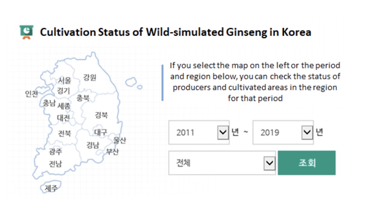
Comprehensive Information system on Wild Ginseng Cultivation
Wild simulated ginseng is one of the forest products which needs special care by the government, so its production process and quality control information are available via an online system. Wild simulated ginseng which passes quality tests are certified with an inspection number and a Quick Response (QR) code and the public can obtain general information on the cultivator and history of wild simulated ginseng by inputting either the inspection number or the name of the cultivator in the online system. The online system also provides further information including current status of ginseng cultivation as shown in the below picture, quality control system, the history of ginseng cultivation and management, and information on the legal history of special care forest products.
Conceptual Diagram of Integrated Forest Disaster Management System
Source: Comprehensive Information system on wild simulated ginseng
The public can easily find the information on the current status of cultivation of wild simulated ginseng throughout the country by clicking the region on the map or setting specific time periods.
Forest Product Price Information System
The public can search daily price information on 112 products including tree fruits, wild greens and herbs distributed at 34 wholesale markets across the country. It provides information on imported wood prices as well as price trends for the past three years and direct transaction between producers and consumers so that forest community can draw up a tree cultivation plan as it makes possible to predict economic benefits of tree species.
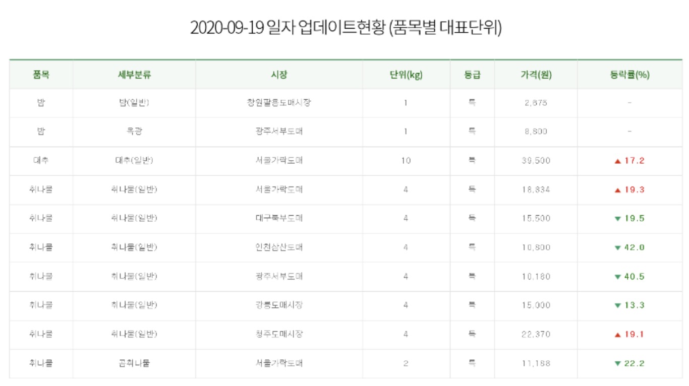
Source: Forest Product Price Information System
New technologies to monitor, manage, and expand forests will become more mainstreamed in the future. They offer new ways in which countries can leverage global good practice related to forests and adapt these to their own needs, as well as find ways to contribute to good practice with their efforts. Forests also need to be considered in the larger Landscape context as described in the next section.