The world has many types of landscapes – the term is flexibly used to cover a relevant spatial area with common features – these could range from watersheds, deserts, deltas and coastal zones or large areas such as the Sahel in Africa. They face many challenges that need to be explored in a spatial, multi-sectoral context integrating environmental, social, and economic perspectives. Many landscapes are facing threats of climate risks and degradation as land, water and other resources are not used and managed in a sustainable manner.
Landscapes – At a Glance
-
We lose over 75 billion tons of fertile soil every year to erosion – a pity given that it takes about 500 years to form an inch of topsoil!
-
Soils store over 4 trillion tons of Carbon (compare to 0.4 trillion tons stored in forests).
-
Every 1% increase in soil organic matter helps soil hold 20,000 gallons more water per acre.
-
About 42% of the world’s poorest live on degraded land. Worsening land degradation adversely impacts 3.2 billion people globally and is estimated to cost US$ 6.3-10.6 trillion annually.
-
About 2 billion hectares of deforested and degraded land could be restored to functional, productive ecosystems.
There are many opportunities today to use new technologies to modernize the 3Is (information, institutions, and investment) aspects of managing landscapes.
Information
In-situ Monitoring
There are new opportunities to monitor various aspects of landscapes and watersheds with in-situ sensors (e.g. to monitor climate, snow, surface and ground water levels and quality, flow, etc.) in innovative ways. Please see below an evolving collection we have put together of different types of monitoring.
There are many evolving innovations that are reducing the costs and improving reliability of such in-situ monitoring that is slowly moving to be part of an internet of things approach. For example, there are new ways to use 3D printing to dramatically reduce costs of monitoring systems (for example, see 3D PAWS).
Internet of Plants
Based on the concept of the internet of things, researchers are exploring the possibility of embedding nano sensors in the sap flow or monitoring the movement of plants, to be able to collect and transfer data about their chemical, physical, physiological and environmental needs. the internet of plants , could improve productivity and help address food shortages, while enabling a united network that be monitor more accurately local weather and critical environmental changes. The internet of plants is still in its early stage but hold a lot of promise. The Plantenna project coordinated by the TU Delft University is pioneering this cyber plant technology.
Big Data for Livestock Management
There are new ways in which big data and cloud services are being used to revolutionize livestock management.
Surveys
Collecting data quickly in challenging environments such as when natural disaster occur is imperative to being able to offer help during emergencies, having reliable open-source data collections facilities getting the needed help such environments efficiently and in a timely manner. The KoBoToolBox offers aid professionals and researchers access to critical data to offer needed help to those affected by such disasters.
The World Bank’s Open Government Data Toolkit is designed to help governments, Bank staff and users understand the basic precepts of Open Data, then get “up to speed” in planning and implementing an open government data program, while avoiding common pitfalls. The World Bank is also helping with new open systems for CAPI (Computer-Assisted Personal Interviews) systems for household surveys.
Earth Observation
Earth Observation has a key role in generating global datasets relevant to the study of Landscapes. Analyzing Land Cover changes provides valuable information to assess climate change impacts on habitats, biodiversity and natural resources. Other applications of this data are disaster management, vulnerability and risk assessments, monitoring the effects of climate change, environmental policy development, wildlife management and many more.
The European Spatial Agency, in the framework of the Copernicus Climate Change Service (C3S) released the global land cover products, available from 1992 to 2018. The data describe the land surface into 22 classes at 300 m resolution and gives a global perspective of the landscape’s composition around the globe. Have a look at the dataset in the visualization below.
The NASA has also developed its Land Cover Dataset using data from the Terra and Aqua satellites. The Moderate resolution Imaging Spectroradiometer (MODIS) sensor provides the data behind the Land Cover layer. This product’s data is refined to fit into 17 land cover types based on the International Geosphere-Biosphere Programme (IGBP) classification scheme, including 11 natural vegetation classes, three human-altered classes, and three non-vegetated classes. The temporal resolution covers from 2001 to 2018 and it has a spatial resolution of 500 meters.
The Normalized Difference Vegetation Index (NDVI) is a graphical indicator to assess the presence of live green vegetation within an area. The analysis of the data allows researchers to create detailed maps of the Earth green vegetation density, which allows us to identify where plants are thriving and where they are under stress. This indicator has many applications in agriculture to provide crop health information, but also can be used as an indicator of drought .
Watershed Analytics
There is a rapidly changing world of modern data services, online/cloud analytics and data visualization, and e-packaging that has resulted in a range of new free/public domain and subscription solutions that can be used to reimaging the often-tedious traditional processes of analysis that multi-sectoral spatial watershed analytics demands.
An example of free public-domain often global data and analytical services available for anyone to use for watershed analytics are illustrated in this World Bank Hydro Informatics platform:
In addition, there are a range of new modeling approaches that can be used to improve scenario analysis using simulation, optimization, or multi-criteria techniques in a range of free and commercial models as shown in this rapid modeling review. An exciting new range of online models (accessible through APIs) such as HAWQS is now emerging that should help herald in an even more agile age of complex analytics on any device such as a smartphone without having to download and install any additional software. Some of the more common models that have been in use for various types of analytics in a watershed/landscape setting are outline below.
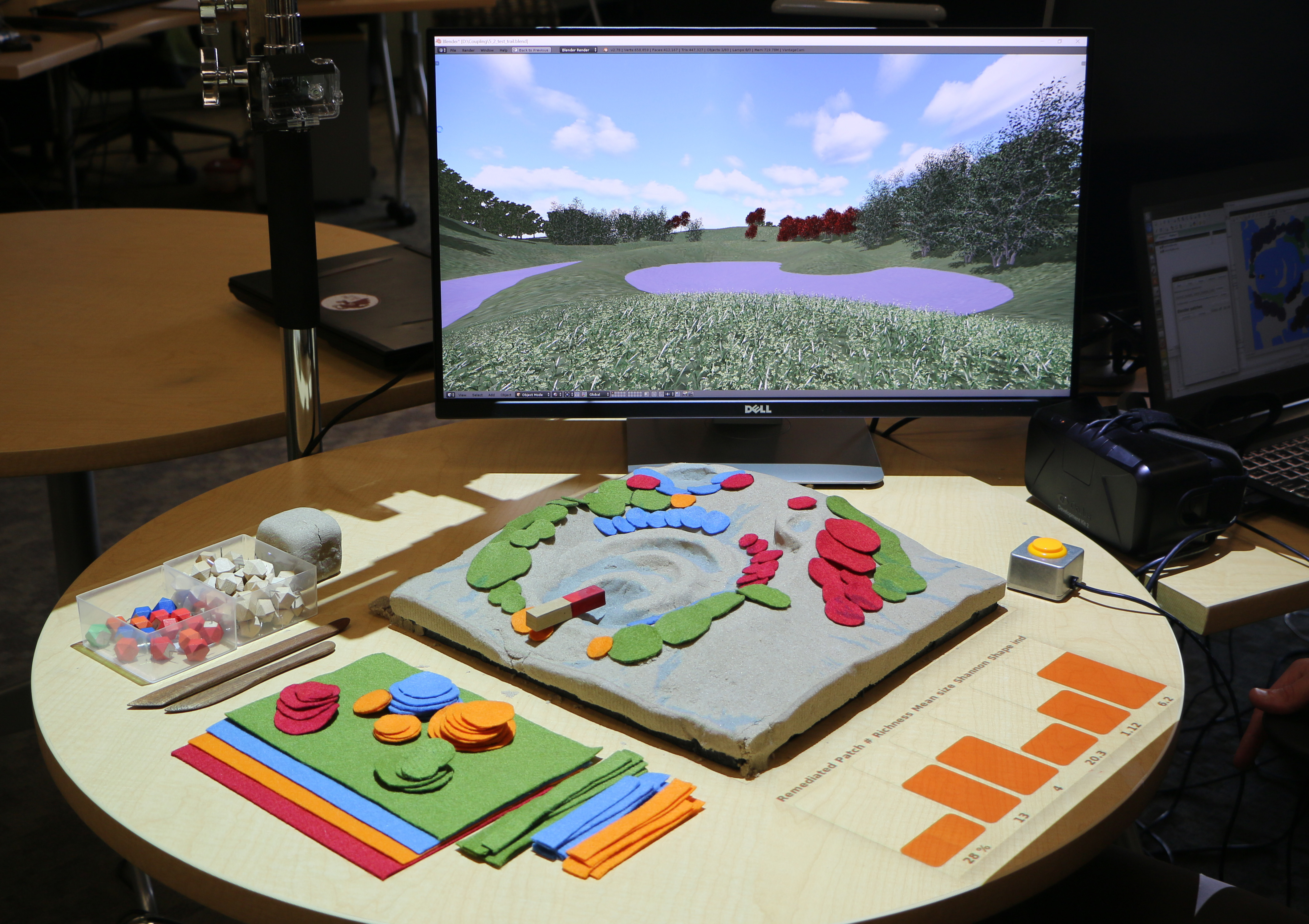
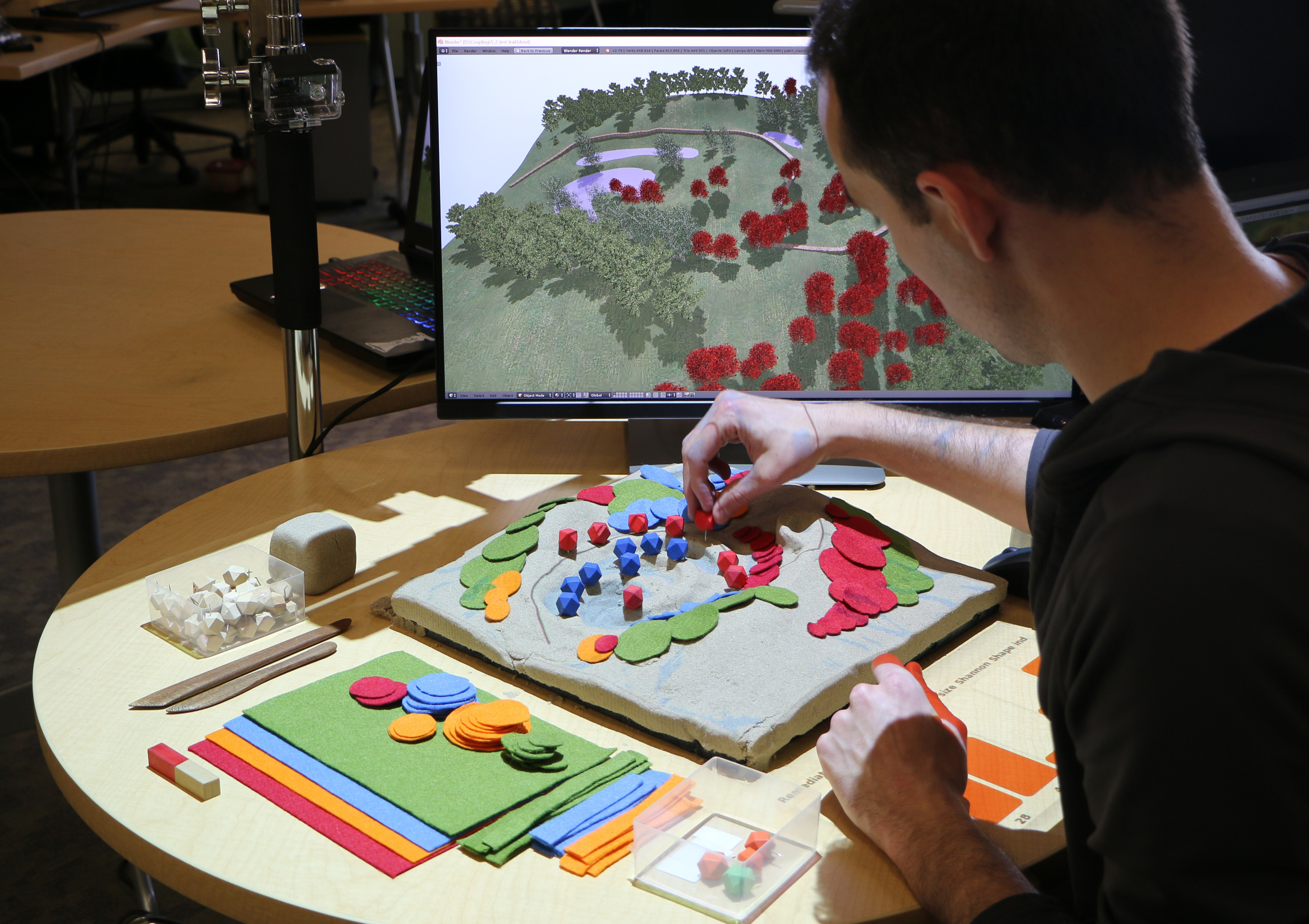
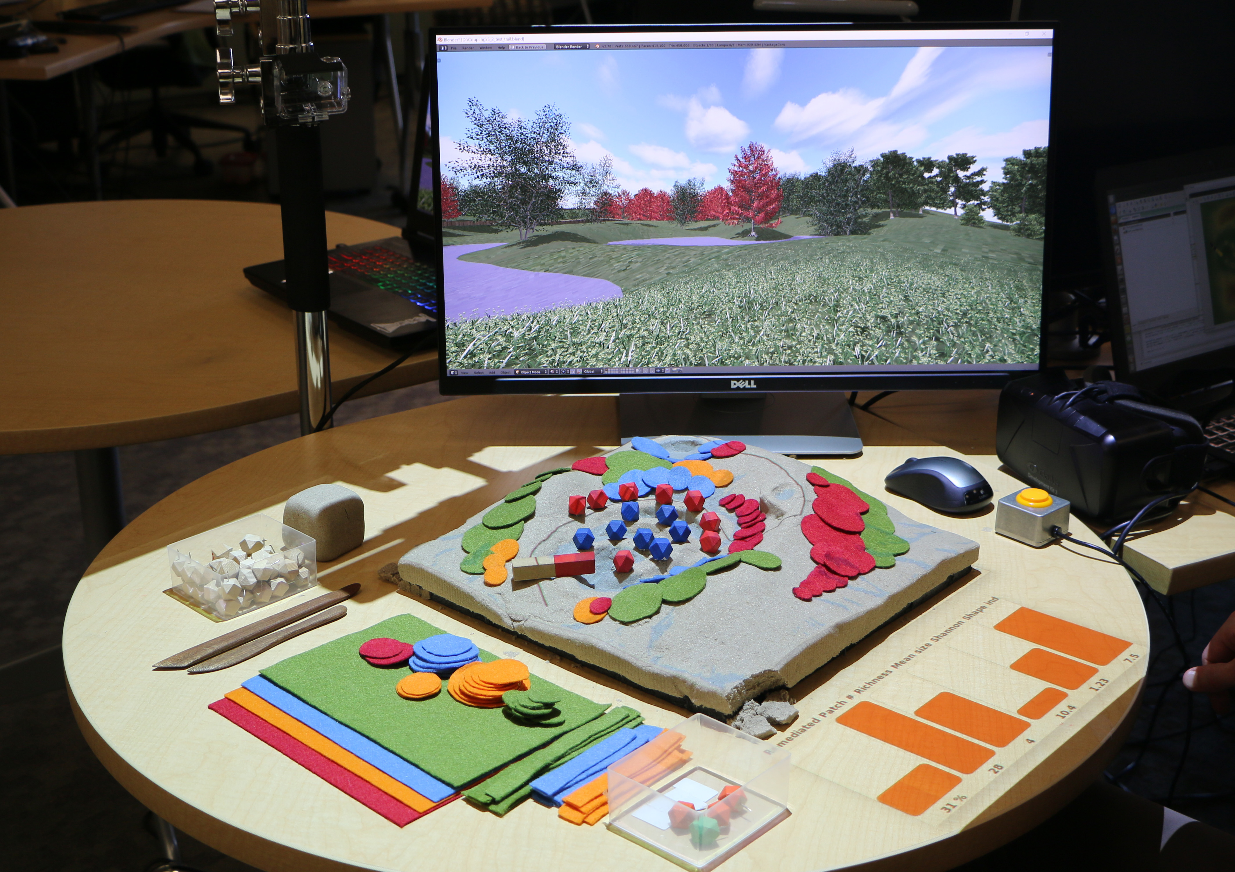
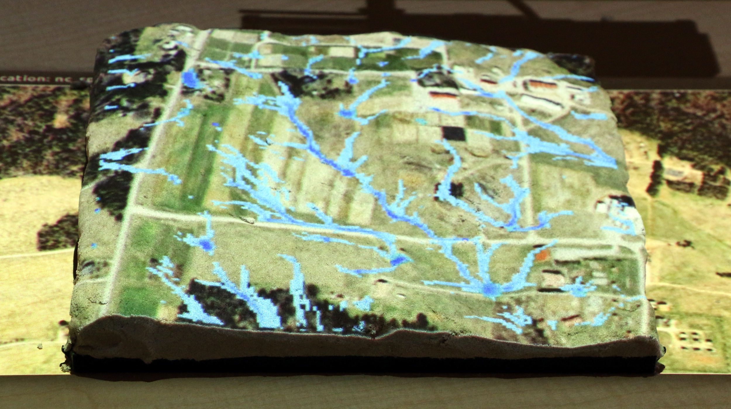
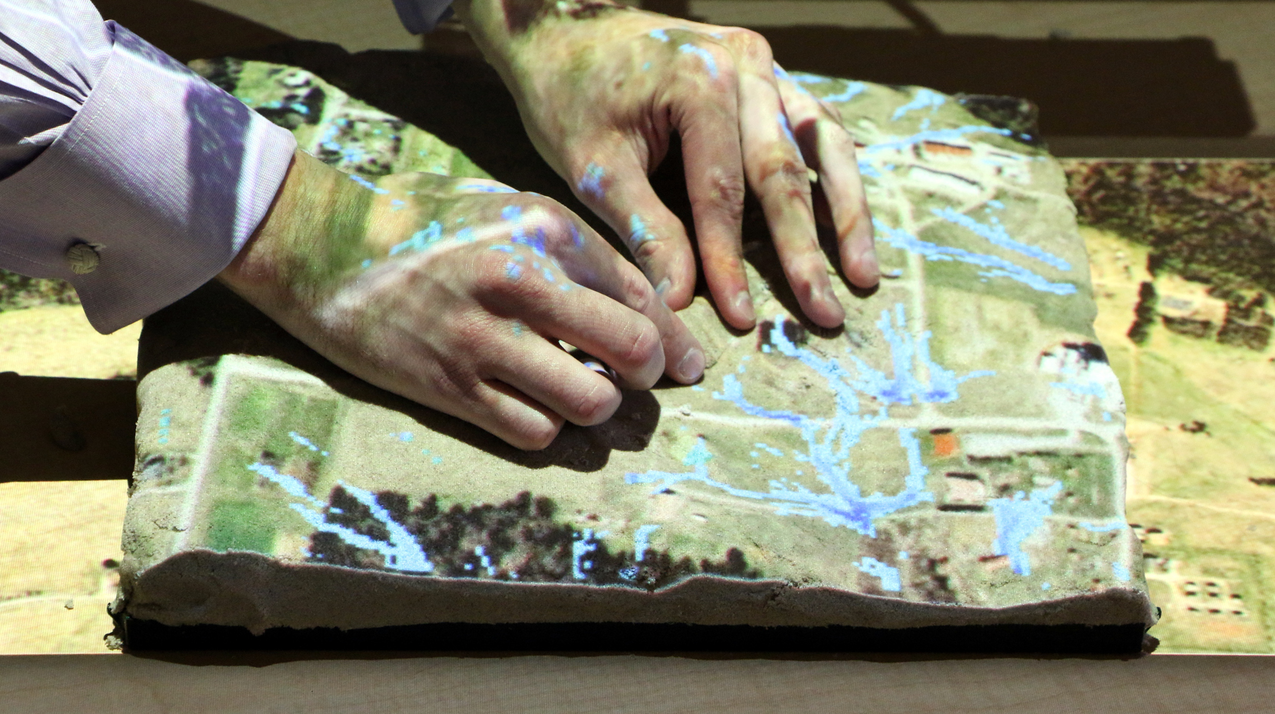
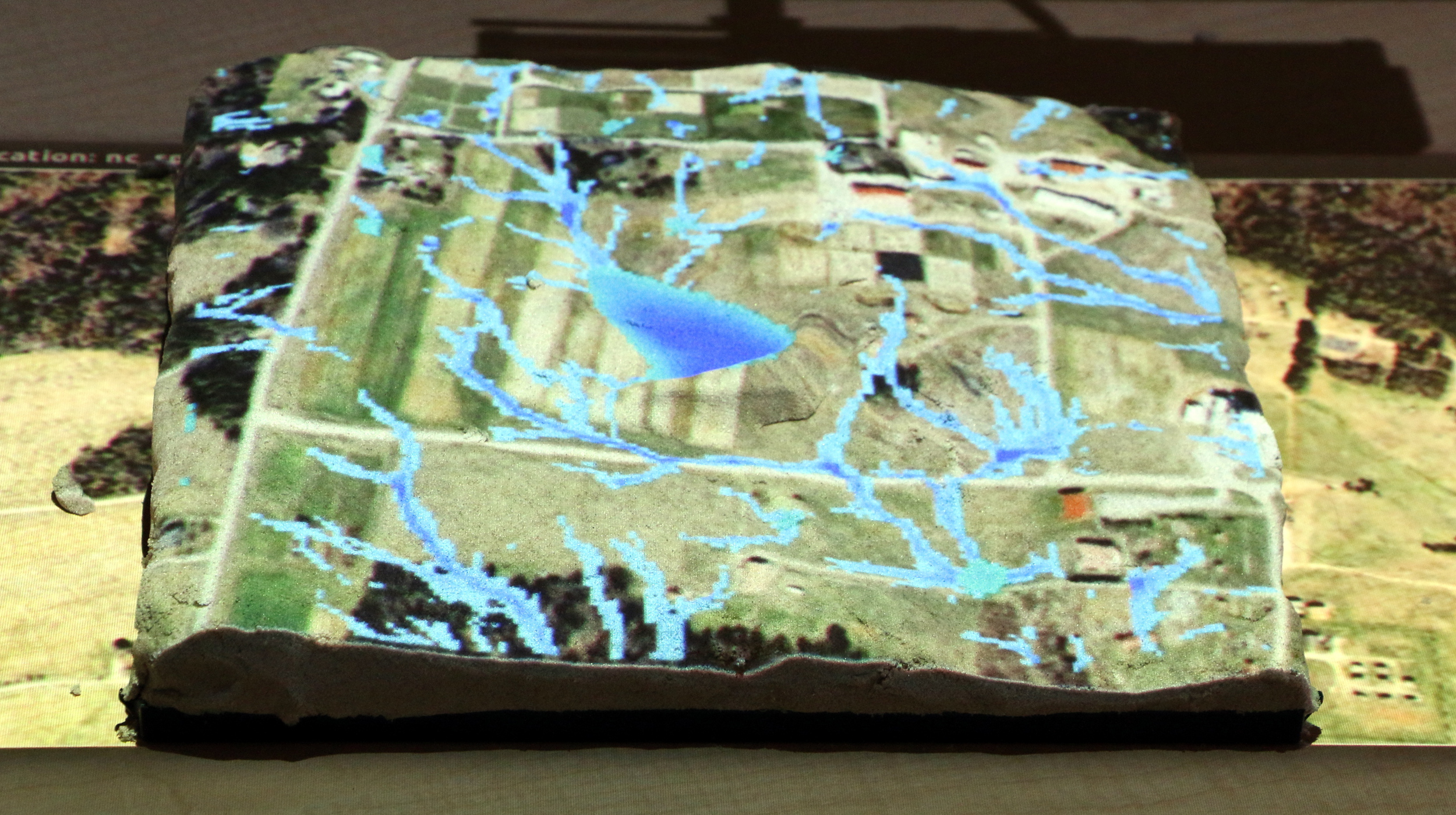
Tangible Landscapes
This tool, created by the NCSU GeoForAll Lab from the North Carolina State University, Center for Geospatial Analytics in Raleigh, NC, USA. is an open source tangible interface for geospatial modeling powered by GRASS GIS. It offers a very innovative way to combine physical models with computer analytics and projected images to offer new ways to visualize and communicate the implications of possible future scenarios in different types of landscapes.
The technology consists of a combination of a scanner, projector and a physical 3D model powered by GRASS GIS. The objective of this new concept of interactive modelling landscape is to analyze the impact of terrain changes by capturing the changes on the physical 3D model, bringing them into the GIS via the scanner and projector and finally performing desired analysis or simulation and projecting the results back on the model.
Leveraging GRASS GIS's extensive libraries for geospatial modeling, analysis, and simulation the Tangible Landscape technology now cover a wide range of applications.
- Design and planning applications (such as grading, cut and fill analysis, stormwater management, erosion control, trail planning, viewshed analysis, and the assessment of solar potential)
- Scientific applications (such as subsurface visualization, urban growth modeling, disease management, and invasive species management)
- Disaster management applications (such as flood control, wildfire management, and coastal change and adaptation. Educational applications include spatial training and serious gaming)
Machine Learning / Artificial Intelligence
As we look ahead, one of the most exciting (and sometimes scary!) developments related to the way information is processed is in the field of artificial intelligence (AI). As an example, one aspect of AI is Machine Learning where computer algorithms are trained to be smarter. For example, if you look at a high-resolution satellite image and select a few objects (e.g. trees, cars) and tag them as such, the algorithms can then “learn” especially with more corrections along the way, to recognize these in larger areas and then perform analytics based on this identification. There are now a range of free (e.g. TensorFlow) and subscription services that are helping illustrate the tremendous potential of these systems that will become more and more mainstreamed in the future to support decisions based on a range of data inputs.
Explore how you can create an urban green map using such a tool!
Institutions
Institutional Infrastructure
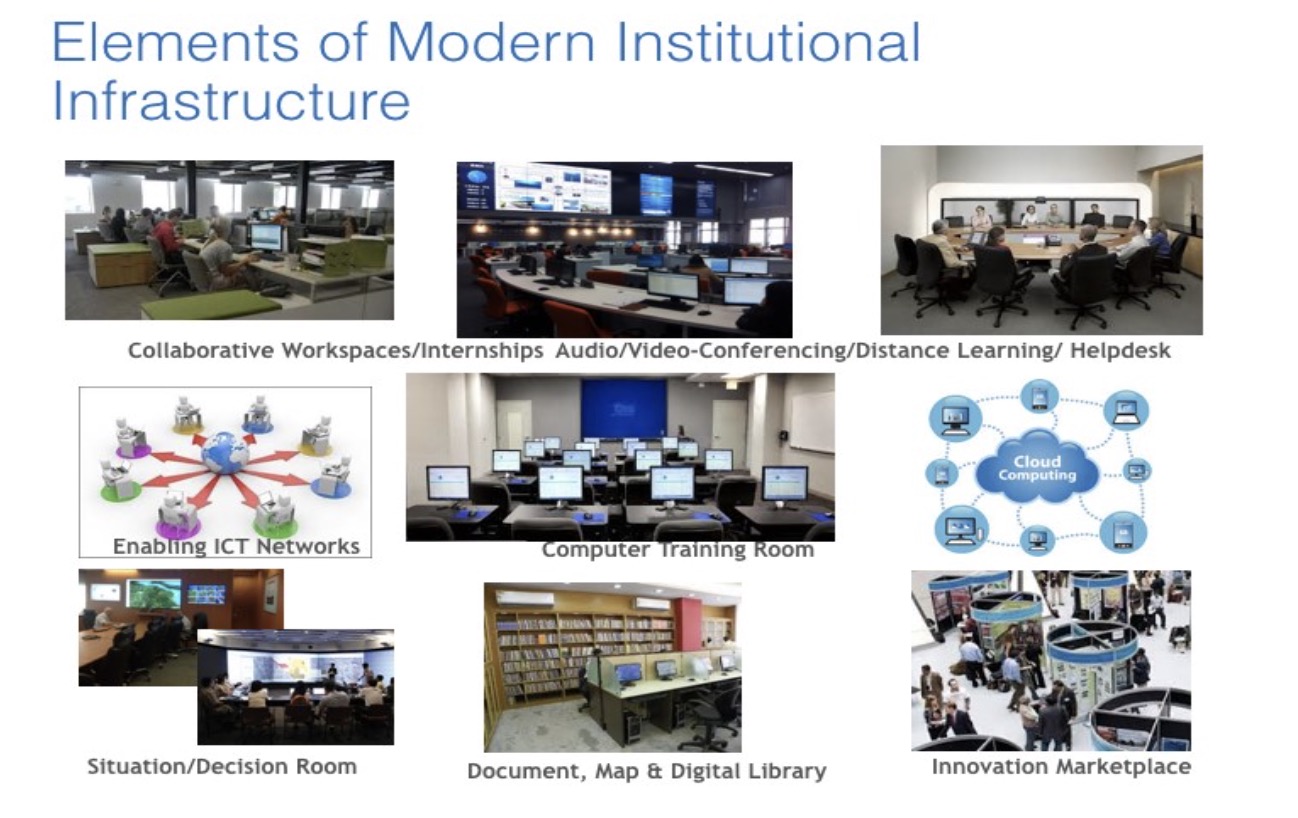
A key issue in promoting the use of ICT in forest-related institutions is to ensure that such institutions have adequate institutional infrastructure (e.g., IT (Information Technology) equipment, networking, videoconferencing, computer training rooms, etc.) that can facilitate the mainstreaming of ICT tools into their business processes. Given the rapid development of ICT, it is critical that this includes provision for the adequate governance of the ICT infrastructure (e.g., to ensure data security, data integrity, managing viruses and other similar threats, maintenance, updating, etc.) with appropriate staffing and continuous learning and modernization.
Capacity-building
Technology can be leveraged to rethink capacity-building on landscapes. This includes e-learning options (e.g. explore the self-paced Landscapes 101 e-course from the World Bank), but can also include ways to have communities learn from each other (e.g. through farmers establishing video channels sharing on YouTube). Modern data and analytics with the support of automation has also changed the required skill-level of users (e.g. to access weather or market price information) and focus the capacity-building needs on how to access this new world of information and analytics and interpret this for their use.
Community Services
Around the world, there are a range of organizations providing community services to improve landscapes. These include the Government (e.g. through their own financing and with the support of grants and loans from development partners), Civil Society Organizations (international, regional, national, and local level), Private Sector (e.g. through Corporate Social and Environmental Responsibility financing and as social business ventures), Academia (through knowledge outreach and spinoffs), as well as Community organizations (local self-government, water/watershed user associations, farmer organizations, etc.). These have resulted in a significant scale of investments (often leveraging modern technology) to improve community involvement and ownership of their local landscapes to improve their productivity and sustainability.
One of the most important developments is the development of online marketplaces that are now helping network producers and buyers with smart logistics and creative apps and online platforms. China is at the forefront of this agricultural e-commerce and its firms such as JD, Alibaba (esp. Taobao) and rapidly expanding upstart PinDuoDuo have set up innovative online platforms to help farmers even in remote areas reach national, regional, and even global markets. Many of the farmers have started exploring the benefits of livestreaming in order to manage the challenges of COVID.
Established in 2016 by WWF, Landscape Finance Lab is incubating a portfolio of quality landscape programs in priority areas through community-based consultations . The purpose of the lab is to test innovative financing mechanisms and build sector learning, capacity and impact for the global community.
Kisan Suvidha is a mobile application which aims at development of villages and empowering the farmers. The app provides a user-friendly interface with information on current weather and forecast for the next five days, market prices of commodities/crops in the nearest town, knowledge on fertilizers, seeds, machinery etc. In order to make it more accessible, the app is also available in different languages. An online portal is also available for the same.
Through use of virtual courses, news, articles, and social networks, CropLife is helping train hundreds of thousands of people in Latin America and Asia on aspects including responsible use of pesticides, good agricultural practices, pollinators and making them aware about new innovations and technologies.
Plantix application to help control pest and diseases: FAO estimates 20-40 percent of global crop yields are reduced each year because of plant diseases and pests. Developed by a Berlin-based AI startup, Plantix is a mobile crop advisory app for farmers to diagnose pest damage, various plant diseases and nutrient deficiencies affecting crops and offers treatment measures for the same. The platform provides for an online community of scientists, farmers and plant experts to discuss several plant health issues and access local weather reports.
Korea Smart Farming Innovation Model : Smart farming brings information and communications technology to greenhouses and livestock farms and enabling farmer to control remotely, the growing environment of crops and animals powered by artificial intelligence, big data, and internet of things on smartphones and computers. The Ministry of Agriculture, Food and Rural affairs, plans to allocate 203 million USD to boost the country’s smart farming industry. Through the ministry, the government plans to provide farmers with smart testbeds and smart farms for leasing. The budget also facilitates the training of young farmers.
Investments
There are many parts of the world where significant potential exists to restore landscapes. The Atlas of Forest and Landscape Restoration Opportunities identifies such opportunities for forest landscape restoration. The atlas contains several embedded maps on land restoration opportunity areas, current condition and extent of forests and woodlands, and human pressure (land use intensity and population density). According to the World Resources Institute, for every $1 invested in land restoration it can yield $7-$30 in benefits.

The Bonn Challenge seeks to bring 150 million hectares of degraded and deforested landscapes into restoration by 2020 and 350 million hectares by 2030. One of the much needed initiatives to restore the land can be seen in the form of AFR100 , wherein African Union takes the lead by committing to restore 100 million hectares of land by 2030 with its partners earmarking over USD $1 billion in development finance. WRI’s Initiative 20x20 is another such another example which aims to restore 20 million hectares of land in Latin America and the Caribbean through agroforestry, silvopasture, and other sustainable land use initiatives.

Afforestation using Drones
Trees are an essential component to keep our environment clean. According to a Nature study, around 15 billion trees are cut every year. Many projects of afforestation are underway using automated tree planting using drones in India and Myanmar . To scale up ecosystem restoration efforts Research institutes such as the Indian Institute of Science Bangalore, are planting trees using drones to reforest large areas of land. The use of Unmanned Autonomous Vehicles (UAVs), commonly known as drones, makes it possible to have a more precise image of the area to be seeded and, this technology allows results monitoring to ensure trees are growing in optimal conditions. There are startups such as Oxford based Dendra using a combination of drone technology and artificial intelligence, to restore former mine and degraded farmland in Australia and Mangrove reforestation in Myanmar. Drones are used to survey the sites to capture data on the state of the land, that is combined with data from ecologists. Artificial intelligence is then used to analyze data to identify the types of plants and animals on the site and the size of the land. The seeds are specialized to ensure optimum growth, the drones further allow access to difficult areas in less time than using traditional methods. Two operators working with 10 drones can theoretically plant 400,000 trees in a day and in Myanmar the aim is to replant 1 billion trees.
Innovation in Landscape Investments
WOCAT
In an effort to compile, document, evaluate, share, disseminate and apply knowledge for sustainable land management, The World Overview of Conservation Approaches and Technologies (WOCAT) a Global Network was established. WOCAT’s efforts in sustainable land management focus on preventing and reducing land degradation through Soil and Water Conservation (SWC)technologies and their implementation approaches.
WRI’s Land Accelerator Program is helping train and support hundreds of entrepreneurs to restore degraded land through boosting investments in sustainable and innovative businesses. The program provides a platform for horizontal exchange of knowledge and technical expertise through bootcamps, regular discussions within the network.
Nature-nased solutions
Nature-Based Solutions are a fundamental part of action for climate and biodiversity. Authoritative research indicates that Nature-Based Solutions can provide over one-third of the cost-effective climate mitigation needed between now and 2030 to stabilize warming to below 2 °C, achieving nature’s mitigation potential of 10-12 gigatons of CO2 per year. (UN global compact).
The Bonn Challenge, using a nuanced nature-based solution coined the Forest Landscape Restoration (FLR), which seeks to restore the ecological functionality of degraded and deforested landscapes, while enhancing the well-being of people coexisting with these places. Launched in 2011, the largest landscape restoration effort, with the aim to restore 150 million hectares of degraded and forested landscapes by 2020 and 350 million hectares by 2030, the challenge surpassed the 150-million-hectare milestone for pledges by 2017. Currently there are 61 countries involved and 74 pledges of various thousands of hectares of landscapes being restore, globally.
In Demak Indonesia, the government, residents, NGOS and universities are working together on Building with Nature project to restore a 12-mile belt of mangroves, this project has already improved climate resilience, provided communities from coastal flooding and absorbed carbon dioxide from the atmosphere.
The World Bank, Global Fund for Disaster Reduction and Recovery and Deltares , have developed an online hub, The Nature Hazards-Nature Based Platforms for nature-based solutions for reducing risks of natural hazards, this repository contains projects, investments, guidance and studies.
Constructed wetlands have been popular in the developed world and are also being explored in the developing world and can provide a range of landscape benefits. Green Roofs are also becoming increasingly popular and more engineered to provide a range of services especially in urban contexts for low impact development.
Managing the Fall Armyworm
FAO’S Nuru and Fall Armyworm Monitoring and Early Warning System(FAMEWS) mobile apps.
The fall army worm which first appeared in Africa in 2016 and has rapidly spread across countries in the region destroying millions of hectares of maize, threatening the food security of more than 300 million people (FAO). Thus, the Nuru App was developed, a collaboration between the University of Pennsylvania and the FAO. The app uses machine learning and artificial intelligence to help farmers I identify crops that are affected by the fall army worm. Once downloaded onto a phone the app works both and offline enabling farmers without access to the internet to also use it. Farmers hold the phone next an infested plan to confirm if damage was caused by the fall army worm, then the app suggests next steps to stop the spread of disease. This app complements the FAO’S Fall Armyworm Monitoring and Early Warning System(FAMEWS) mobile app, which is a knowledge base of how, where the pest spread and what makes it less damaging. The Nuru App is used in East Africa as well for disease detection in cassava plants.
Agricultural Technologies
Robots are being used in agriculture to automate repetitive tasks crops such as weed control, harvesting, and picking, seeding, spraying, and packaging and so on, increasing efficiency on farms and increasing food production. Harvesting and picking is most of the use of robots on farms e.g. harvesting, strawberries and peppers.
UK based RootWave has developed a technology to sustainably and regeneratively kill weeds without the use of harmful chemicals. It can be powered by renewable energy and can create healthy soils and capture carbon. Electricides are used to boil weeds inside out from the root upwards using electricity and the technology can treat any weed including tough invasive species.
Mobile Interventions and Technologies for Rural Areas (MITRA) is a mobile application which provides advice on fertilizer needs and doses for farmers. Available both in English and Tamil, farmers can also access information on macro and micronutrient deficiency and remedial measures. The App can also work in an offline mode.
Israel based CropX developed a cloud-based software solution integrated with wireless sensors to boost crops yield and save water and energy. Field validation suggests that the technology can conserve water by over 30 percent and generate crop yield enhancement of around 10 percent. The CropX app can help identify the right amount of water to be used to irrigate the field, through irrigation prescription which constantly adapts to the changing conditions of the field. The technology can help predict water-uptake patterns and detect faulty irrigation system and burst pipes.
Chicago-based Hazel Technologies provide horticulture consulting services to the growers and shippers and helps ensure shelf-life extensions of various fruits. In addition, biotechnology is being leveraged to reduce waste in the agricultural supply chain.
Planty Cube is an IoT enabled from N.thing, vertical farm with that cultivates high quality vegetables in a fully controlled environment that increases yield. Farms can be started as small units and increased by adding on more units(cubes) as needed, Planty Cube is a smart hydroponic farm is shaped like a shipping container, with stacked rows and shelves of planters on each wall. Seeds are planted via their smart seed capsules, specialized LED lights and internet-connected sensors thar allow year-round cultivation without the constant need for human intervention. The cultivation environment in the cube is completely controlled, thus temperature and humidity are kept at optimal levels and pests are prevented. The LEDs also give the optimal amount of light required for photosynthesis. There is a continuous collection of data, that is logged into a database, for continuous optimization of conditions for each plant. there is a cube cloud, that stores all the data generated, for managing the various farms and providing production orders and alarms for each of the farm, easing the management (from anywhere at any time) and cultivation of the farms. Farmers are also able to cultivate specialty vegetables for different circumstances, because of the ability to control the environment and plant nutrients.
Eco Tourism
Beach cleaning robots for eco-tourism: powered by solar energy, Solarino is the first mobile sand beach cleaner robot developed by an Italian company Dronyx which can clean rubbish and other foreign matter both on wet and dry sandy terrain, in a silent and ecofriendly manner. Following is a technical video showcasing the working of the robot.
vEcotourism , invented in 2004 is using interactive on-line tours to connect the general public with conservation projects and local communities in ecologically and culturally sensitive areas worldwide.
vEcotours are currently being produced in Uganda, the Democratic Republic of the Congo, and Indonesia, with a plan to grow worldwide. vEcotour can be thought of a series of immersive 360-degree photographs combined with introductory voiceovers for each panorama, ambient background audio, still images, and embedded videos. vEcotourism has a huge potential to overcome the challenges of ecotourism including high price, and in some cases high carbon footprint, and development of roads and infrastructure which could have a detrimental effect on wildlife.
Korea ICT-based Integrated Water Resource Management
K-water has applied IWRM (integrated water resource management) practices across the whole process of water cycle, which would enable the efficient use and management of water resources, including rainfall and water flowing from basins and rivers.
Water Information Survey, Management and Analysis Technologies
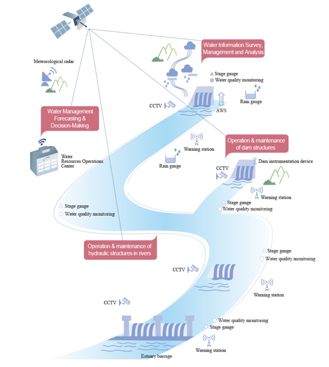
Source: K-water
K-water is the only organization in Korea that is equipped with professional capabilities to perform various surveys & investigations on all areas of water resources, including hydrological survey, basin survey, groundwater survey, etc. All water-related information and data acquired on a real-time basis are accessible to all people via the ICT-based RHDAPS (Real-time Hydrological Data Acquisition & Processing System) or the national water-related portal systems. These data are also used to develop new policies on water resources or new water-related project opportunities.
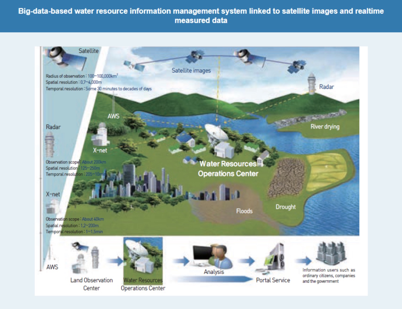
Water Management Forecasting & Decision-Making Technologies
Source: K-water
K-water has been continuously developing its own precipitation forecasting & decision-making technologies to ensure the efficient management of water resources even under unfavorable water management environment unique to Korea where regional & seasonal variations in precipitation are very substantial with the frequent occurrence of extreme weather events (e.g., flood accompanying a typhoon, abnormal drought). Also, K-water can provide packaged, customized water management solutions from those technologies for different kinds of end users.
K-water Hydro Intelligent Toolkit (K-HIT) is a decision support package converged with advanced ICTs and linked with individual water management technologies, which will ensure flood control & reliable water supply and monitoring based on real-time data. It consists of:
-
RHDAPS (Real-time Hydrological Data Acquisition and Processing System)
-
PFS (Precipitation Forecasting System): K-PPM (for short-term predictions), CAM (for long-term predictions)
-
FAS (Flood Analysis System): COSFIM (Coordinated dams' analysis)
-
K-DRUM (Distributed Rainfall Runoff Model)
-
RWSS (Reservoir Water Supply System)
-
GIOS (Generation Integrated Operational System)
Hydraulic Infrastructure Maintenance & Safety Management Technologies
As part of efforts to ensure the stability & safety of water resource management infrastructure against various risk factors (e.g., extreme storm events, earthquake, aged structures, etc.), K-water has been making efforts to improve its own flood control capacity, as through building new emergency spillways and connecting dams for their integrated operation. Also, K-water has applied prevention-oriented safety management practices by developing & building the ICT-based integrated safety management system which allows real-time measurements with various kinds of embedded instruments and real-time monitoring of seismic events and adopting quality dam risk analysis & assessment methods.
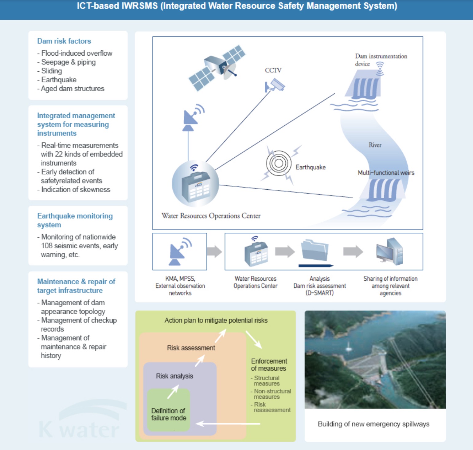
Source: K-water
Water-Quality Management of Basins, Rivers and Reservoirs
K-water has developed and applied SURIAN (Supercomputer-based River Analysis Network), a real-time water quality forecasting & monitoring system, which allows linkage among weather, basin, dam and river models to maintain a sound water ecosystem where human beings and nature can coexist harmoniously. With SURIAN, K-water has made lots of efforts to minimize the impacts of water-quality changes on the ecosystem and ensure the sustainable development of water resources & hydraulic infrastructure using various water ecosystem restoration technologies.
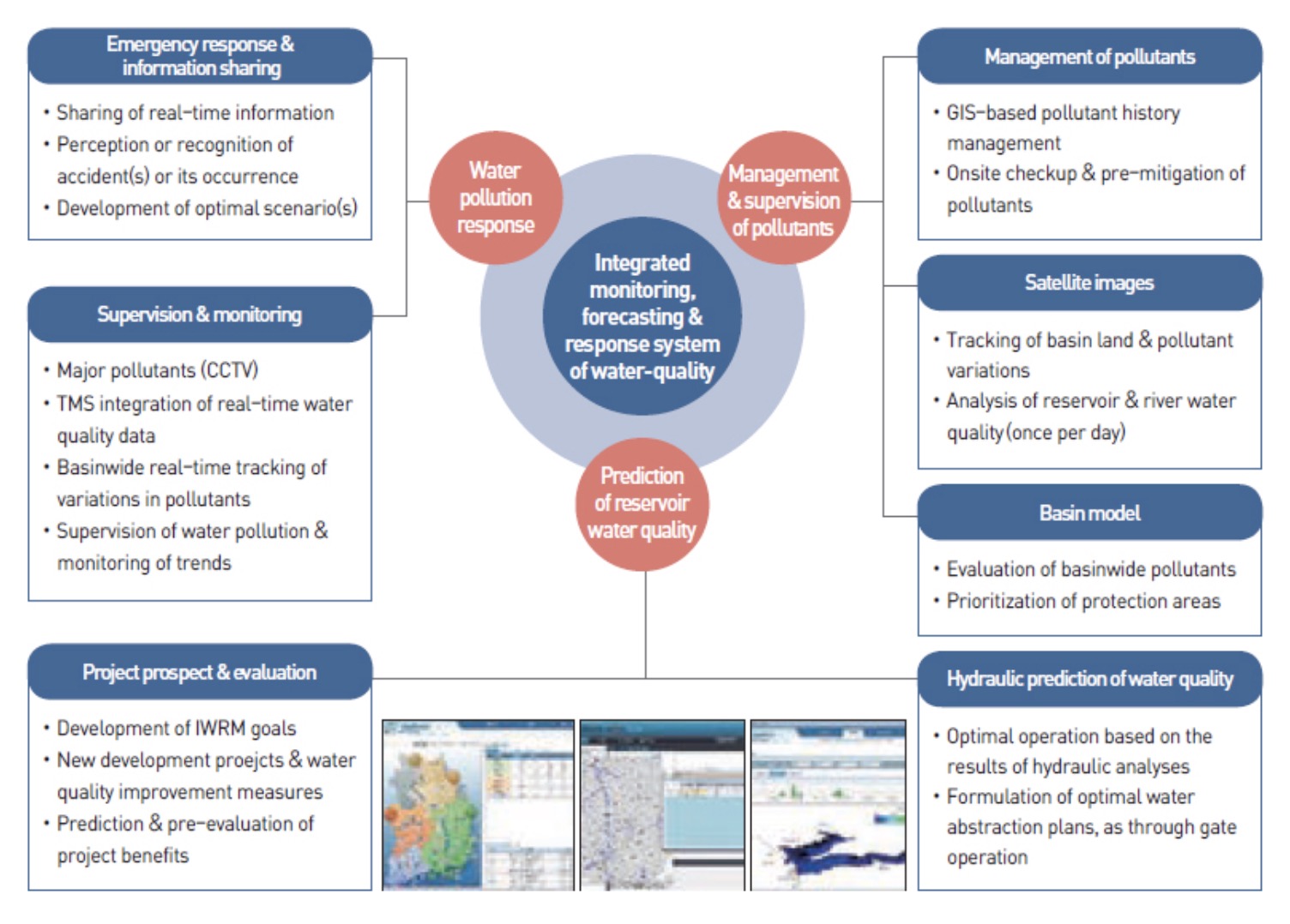
Source:K-water
Greening Development
As we look ahead, there could be a significant impact of using a new generation of rapidly-evolving technologies in the management of green assets.
Biodiversity could be better managed with better data (especially free, public online data services) and analytics that are integrated into investment planning, including for environmental assessments (including analysis of alternatives). Innovative tools to manage protected areas (e.g. using sensors, drones, and earth observation) could help bring down costs and improve coverage of these areas to protect the flora and fauna while reducing poaching.
The world’s threatened forests could be better managed both through improved data/analytics and innovations to help governments and local communities monitor and protect these precious habitats that provide many ecosystem services.
Addressing the green environment effectively requires the consideration of landscapes as spatial contexts that require more multi-sectoral approaches. This requires more widespread use of technologically-driven innovations related to information, institutions, and investments. This will also be discussed in the “Integrated Approaches” chapter at the end of the GreenTech e-book.