Integrated Spatial Approaches – At a Glance
-
There are 17 Sustainable Development Goals with 169 targets .
-
About 17% of the world’s land drains into internal (endorheic) basins. The largest river basin globally is the Amazon at 6.1 m km2 ).
-
Half the world’s habitable lands are used for agriculture. About 83% of cultivated land is rainfed (95% in Sahelian countries ).
-
Urban areas could expand from 0.6 million km2 in 2000 to 1.1-3.6 million km2 in 2100 .
-
The population living in urban areas could expand from 55% in 2018 to 68% by 2050 . Currently, North America has 82% of its population in urban areas, compared to 43% in Africa.
When we explore a spatial context of a location, we need to explore a watershed, river basin, aquifer dependent area, coastal zone, or other type of landscape or airshed. Each of these is a spatial context that helps explore the inter-relationships between different bio-physical and institutional elements.
For example, in a typical watershed as shown below, there could be a myriad number of intertwined issues managed (usually without appropriate coordination or shared vision) by a range of institutions organized according to governance levels and sectoral responsibilities. These could be central, provincial, or more decentralized governments, land and water users, private sector, academia, civil society organizations, and the general public. In many cases, the scale of the watershed could involve transboundary institutions within and across countries for additional complexity. The real challenge is that most of the biophysical elements are inextricably intertwined across space and time – for example, deforestation in the upper catchments could lead to more soil erosion which could reduce the live storage of dams downstream and the services they can provide for irrigation, water supply, flood management, etc. Or pollution or additional water withdrawal/storage upstream could result in adverse implications for downstream communities.
This is why a more integrated spatial approach is required to be considered to address these issues in a more holistic manner. This usually requires work along the 3Is (Information, Institutions and Policy and Investments), and technology has started to dramatically change what is possible within these 3Is to help provide a shared vision of the spatial approach. Some glimpses into this evolving world are described below.
Information
Developing an integrated spatial approach foremost requires a comprehensive relevant multi-sectoral knowledge base. Accelerating technological advances in the field of informatics has completely “disrupted” this space, with an increasing number of high-quality free and subscription global services and ways of collecting data from the field evolving almost every day to help monitor all key aspects of a landscape. Some of these are illustrated below.
Open Data Services
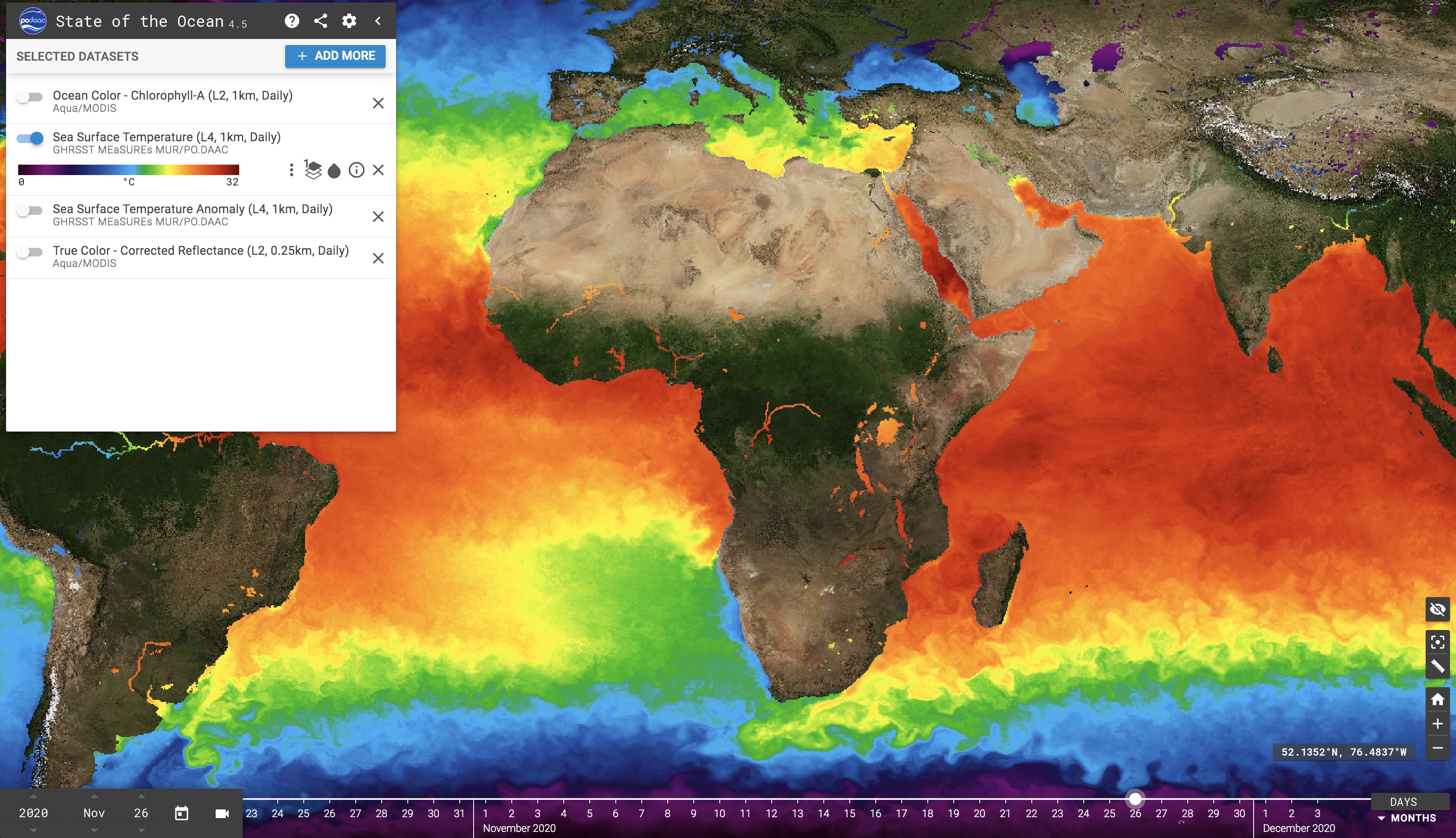
There has been an explosion of free open data services on various aspects of the environment, most of them based on earth observation and global models and providing synoptic global coverage.
Click on the image below to explore global coverage for sea surface temperatures or chlorophyll levels on a daily basis – modern platforms also provide ways to share/embed a particular view or to help access these data through online Open Geospatial Consortium (OGC) service standards or Open APIs which are becoming central to data interoperability and provision of dashboards for visualization and interaction.
Online Analytics
Google Earth Engine (GEE) is a cloud-based platform from Google provides access to multiple repositories of satellite imagery and geospatial datasets allowing quick and accurate analysis and visualization of large datasets available in the cloud, the datasets include free geospatial data, optical and radar satellite imagery, climate information, digital elevation models, land cover maps and a variety of socio-economic variables.
GBDX, by Maxar Technologies, performs geospatial data analytics at scale in the cloud by processing petabytes of information using your custom or their python script. Users work with all off GBDX imagery in the cloud to obtain insight but do not own the raw data.
ESA Thematic Exploitation Platform (TEP) is a collaborative platform that allows users to extract insights from satellite data without downloading any datasets. TEP has seven main interconnected themes: coastal, forestry, hydrology, geohazards, polar, urban, and food security.
Online Visualization
There are many tools that we can use to create interactive online dashboards using a range of free and commercial tools (note that even commercial tools usually have free versions for smaller datasets). These allow us to create and publish interactive maps and charts for use in dashboards or interactive e-documentation.
E-Packaging
Interactive E-books/Storymaps: It is possible today to create more interactive e-packaging of materials to dramatically change the user experience from reading a hardcopy or static digital documents. This GreenTech e-book is an example of e-packaging into an interactive document where the user can access a world of knowledge generated from multiple institutions using the evolving interoperability of systems that allows us to embed accessible videos and other multi-media as well as interactive charts, maps, and other datasets into a narrative. It would be useful for most documents and reports (e.g. State of Environment Reports, Stakeholder Assessments, Basin/Watershed Profiles) to become more interactive in the future to allow users to interact and go deeper into any topic as well as benefit from central updating and being able to quickly access the e-packaged resource from any device (e.g. smartphone, tablet, computer).
Data & Analytics Dashboards: A special form of e-packaging is to be able to access, analyze, an visualize complex data in a highly interactive manner through customized dashboards. For example, as a companion to this GreenTech e-book, we have created a GreenTech Dashboard to help visualize some examples of a growing world of free, public-domain data and analytic services mostly covering the whole world.
Many private sector organizations have developed customized or subscription products and services to address critical needs for empowering users with relevant data and analytics. As an illustration, Upstream Tech service called Lens performs remote supervision at a landscape level. Lens uses remote sensing and machine learning to identify and quantify changes in the environment.
Improved Connectivity
In order to improve the connectivity to read data from sensors and for potential users to access the data, analytics, visualization, and e-packaging services described, there is a need for improved connectivity.
In 2018, only 51 percent of the world used the internet . Companies are solving the lack of connectivity to the under-connected half living in unconnected areas by launching satellites in space to create a constellation that will provide global broadband internet access.
Loon , formerly known as Project Loon , provides internet to rural and remote areas via high altitude balloons that operate within the stratosphere. Loon transmission rate is equivalent to 4G , and the users do not require any special equipment since they receive an internet connection from their local mobile telephone provider.
Microsoft is exploring using TV white space (unused spectrum) technology in order to improve connectivity, especially in rural areas to connect people and sensors.
X, the moonshot factory of Alphabet , is developing a wireless optical communication system called Taara. Data is being transmitted by using a beam of light between two stations instead of cable. A Taara link can cover a distance of 20 KM , and the bandwidth transmission is 20 Gbps.
Digital Twins
A “digital twin” is a digital replica of a physical entity. It is essentially a computer program that uses real world data (e.g., from earth observation, in-situ sensors, crowdsourcing apps, surveys, etc.) and analytics (including AI-enabled) to create a simulated environment (accessible in an interactive graphic representation or a full-blown virtual reality environment) where users can access and interact to get insights to support decisions. This technology is growing rapidly and Deloitte expects it to grow from US$ 3.8 billion in 2019 to US$ 35.8 billion by 2025.
The European Union , has started a digital twin project for earth Destination Earth ( DestinE), this initiative will develop a very high precision digital model of the Earth to monitor and simulate natural and human activity, develop and test scenarios that would facilitate more sustainable development and support European environmental policies. The initiative will contribute to the European Union’s green deal and digital strategy . DestinE’s digital twins will make accessible to users’ high-quality information, services, models, scenarios, forecasts, and visualizations. The digital twins are based on the integration of continuous observation, modelling and high-performance simulation, resulting in highly accurate predictions of future developments.
According to the European Union, DestinE will be developed gradually through the following key milestones:
-
In 2023: Launch of an operational cloud-based enabling platform and the first two digital twins.
-
By 2025: Platform integrates 4-5 operational digital twins and offers services to public sector users for developing, monitoring, and assessing the impact of proposed policy and legislative measures concerning the environment and climate.
-
By 2025-30: Development towards a full digital twin of the Earth through a convergence of the digital twins already offered through the platform. ( EU )
Singapore is heating twice as fast as the world average and previously relied on trees to keep the temperature down. The urban heat island effect is the leading cause of temperature increase where there is a temperature difference of 7 degrees centigrade between the metropolitan area and the surrounding area. To decrease thermal pollution, Singapore developed a computer model called Digital Urban Climate Twin (Duct). Duct is a digital representation of Singapore that includes buildings, traffic, vegetation, land surfaces, people's movement, and climate that allows researchers to design and test scenarios before they are implemented in the real world.
Institutions and Policy
Integrated spatial approaches will require many institutions with overlapping sectoral and spatial jurisdictions to work together. A shared knowledge base with online data and analytic services could be one of the “connective tissues” that knit together the work of several institutions that are responsible for sectoral aspects (e.g. forests, irrigation, water resources, agriculture, urban development, etc.) as well as more integrated institutional constructs (e.g. local government, basin agencies, urban watershed authorities, etc.) for improved management of the land, water, air, and other resources of a region.
There are also a range of policy options that can be technologically enhanced to help assist their formulation, implementation, or monitoring.
Environmental Economics and Policy
China today is looking forward to investing in new ideas to improve water quality and supply. Its “eco-compensation" schemes are helping compensate suppliers of ecosystem services for lost income or land use rights through various policy instruments such as fiscal transfer payments, payments for Watershed Services, and improvement of environmental taxes and fees. One of its trans-provincial eco-compensation systems carried out in East China is helping protect environment while also promoting the green development of local economy.
Payment for Environmental Services
Payments for Environmental Services ( PES) where farmers and landowners are paid for environmental services, this approach was pioneered by Costa Rica and has become particularly common in Latin America. Mexico has the largest such program in the region, with over 2 million hectares of forest receiving conservation payments. The program, which is administered by the National Forest Commission (CONAFOR), pays forest communities $10-$40 per hectare per year to conserve forests, depending on the type of forest and the risk of deforestation.
New York City would have to develop a water filtration plant that would have cost 8-10 billion USD and 250 million USD to maintain. Instead, they purchased thousands of upstream acres to shield a reservoir from pollution and improve economic development in the upstream area.
Increasingly, evolving technology is and will be used to help monitor results for payment of such environmental services both to ensure accuracy and transparency.
Innovative Finance
There are many approaches to pursue innovative finance to address various environmental and climate challenges.
The following video by Global Innovation Lab for Climate Finance shows how well-designed financial instruments can unlock billions for energy efficiency, renewable energy, sustainable transport, and climate-smart agriculture, while also improving private investors’ risks financial returns.
The World Bank Group, OECD and UN Environment “Financing Climate Futures: Rethinking Infrastructure” initiative seeks to transform six key areas which will be critical to aligning financial flows with low-emission and resilient societies (planning, innovation, budgeting, private finance, development finance, and cities).
Investments
Nature-based solutions
Nature-based solutions , of which green infrastructure is a subset, are gaining increasing attention as a method of mitigating disaster risk in a cost-effective manner with multiple co-benefits to people, livelihoods, the environment, and the climate. A key area of current research is understanding how smaller-scale NBS can be brought to scale; a key aspect of NBS is the resilience these solutions build into natural systems and infrastructure at a landscape scale. Key components of NBS are often forests and vegetation, which increase soil stability, sequester carbon, and moderate water flows. These services can reduce erosion and sedimentation on land and carbon dioxide in the atmosphere and can reduce flood risk and stormwater overflows across the landscape.
Nature-based solutions seek to preserve the ecosystem services nature provides by protecting and restoring natural systems. Well-functioning ecosystems provide a host of critical ecosystem services that support the natural world and human society. These services include provisioning, regulating, supporting, and cultural services. Climate regulation has been recognized as a critical ecosystem service that nature can provide. A recent study estimates that natural climate solutions can provide 37% of cost-effective CO2 mitigation needed through 2030 to have a reasonable probability of holding warming to 2 degrees Celsius. NBS focuses on using nature – and particularly vegetation and trees through avoided deforestation, afforestation and green infrastructure – to preserve and increase ecosystem services, thereby reducing natural disaster risks through mitigating flooding, erosion and sedimentation processes, and coastal erosion and sea level rise.
NBS can be implemented at the landscape level, where whole watersheds or ecosystems are managed, protected, and/or restored to positively impact ecosystem services that deliver benefits to agricultural areas, hydropower facilities, waterways, cities, and coastal areas. At the other end of the spectrum, NBS can be implemented at the local level, either as green infrastructure for stormwater mitigation in an urban area, or green infrastructure installed above a road in hilly terrain to prevent landslides originating from higher elevations. Appropriate NBS mitigation measures may be scale dependent.
An innovative approach to monitoring and assessing green infrastructure is provided by Arbor Dron e. This company utilizes drone technology to identify, monitor and assess green infrastructure solutions in urban areas (e.g. urban forest canopy; urban tree pest detection) and increases management capacity from the individual property to urban tree canopy scales. Arbor Drone also utilizes Tree-D technology: machine learning combined with vegetation indices to analyze spectral or photo images to gauge urban tree cover and health.
Really Smart Cities
China is rapidly moving ahead to create a range of smart cities leveraging a range of disruptive technologies. China reportedly has about 800 smart city pilot programs underway or in planning, which would be more than half the total smart cities being pursued currently around the world. Tencent’s smart Net City is expected to be a new paradigm for a post-pandemic world.
MASDAR city in UAE offers to build most sustainable community in the world. Buildings in the city are intelligently designed and powered by green energy, allowing energy and water use to reduce by 40%. The city has clean and smart transportation systems, a real-time urban sustainability lab and narrow walkaways making the city 10 degree Celsius cooler than elsewhere in Abu Dhabi.
Saudi Arabia is also building NEOM as a new concept for urban sustainability. India is pursuing a slow program of smart cities and smart villages.
The hyperloop, currently under development by a number of companies including SpaceX and Virgin Hyperloop , the new form of ground transport aims to reach travel speed over 700 miles per hour in a floating pod racing along in giant low-pressure tubes, with above or underground. The Virgin Hyperloop One recently carried out a passenger test where it travelled the length of a 500m test track in 15 seconds, reaching 107mph (172km/h), the first passenger test ever in a hyperloop.
Virgin Hyperloop One has launched a project in India for a hyperloop to connect Mumbai to Pune, a distance of 117.5km in 25 mins
The American Society of Civil Engineers are exploring new options for cities of the future