There has been an acceleration in the development and deployment of technologies that are “disrupting” traditional ways of perceiving challenges and management. These also show great potential in reimagining how planning and management can help countries and regions effectively and sustainably use groundwater. These will require a coordinated development of information, institutional and investment aspects. Some of the emerging technologies in each of these areas are outlined below.
Information
Digital development has transformed the data value chain to make more informed decisions. This includes new approaches to collect, analyze, visualize, access, and use data to support decisions.
Collecting Data
In-Situ Sensors: There has been a revolution in the use of lower-cost and reliable sensors related to in-situ monitoring of a range of relevant information including weather, surface and ground water levels, surface and ground water quality, soil moisture, etc. Some of these (e.g. 3D-PAWS) also use innovative low-cost 3D printed housing to reduce costs in some cases. Gamma rays naturally emitted from soil are attenuated by soil moisture and new stationary and mobile systems are being explored to monitor soil moisture and other properties in an operational setting. Data transfer is moving from legacy manual systems to dataloggers to now near real-time telemetry (ranging from using broadband to GSM to satellite depending on the situation).
It is expected that billions of sensors will be integrated into many devices leading to an Internet of Things (IoT) – going from an estimated 8.74 billion devices in 2020 to over 25 billion IoT devices a decade later. Countries around the world are scaling-up the use of such sensors in the public and private sector. For example, using IoT sensors, San Francisco piloted a project to measure conductivity, turbidity, pH Level, and oxidation-reduction potential, which is a measurement of how much of the contaminants have been broken down by the water. Data is transmitted via an ultra-narrow band signal that can pass through material and dirt before going into the cloud via cellular or satellite connection.
Data Rescue: Despite the rapid change in technology, many water agencies around the world still have many records in paper form or on many distributed databases such as spreadsheets on individual desktops. These could include information on well logs, fence diagrams, borehole records, streamflow records, water use, climate, metadata, computations, maps, etc. Wherever possible, there is a need to undertake “data rescue” – with the immediate assessment, categorization and digitization of relevant information, integration of these information into digital data in appropriate formats and ideally integrated into online services and a new online system to collect such information in the future.
Apps: There are a range of more digital methods that are starting to replace traditional log registers leveraging increasingly ubiquitous smartphone access (or sms-based systems for legacy access). This facilitates better data entry and also provides a platform for structured and unstructured crowdsourcing of data from targeted users and community monitoring and citizen report cards . These will become more prevalent as connectivity and mobile data access improves and in a few years, 5G could also revolutionize edge computing and access speeds further.
The GGMN - Groundwater Monitoring app enables users to geo-reference and register groundwater monitoring stations and groundwater level monitoring data, with the option of submitting the collected data to the Global Groundwater Monitoring Network. This was inspired by the MyWell App by MARVI in India which is used for collecting and analyzing data related to depths to well water level, rainfall amounts, checkdam water levels and water quality parameters. The crowd sourcing app engages farmers, schools and local communities, displays the current status of the groundwater level in addition to the above parameters, with historical values for comparison and analysis. Systems for crowdsourcing such as IMoMo are also demonstrating approaches to empower communities through the information they collect using technology.
IBM, SweetSense, and the Freshwater Trust piloted a technology that can precisely monitor and manage groundwater consumption in a transparent real-time way using IoT sensors and blockchains as part of California's Sustainable Groundwater Management Act to reduce over-drafting in groundwater basins in the San Joaquin River Basin. Groundwater pumping data is sent to the cloud via a satellite, where the pumping data will be incorporated into a blockchain platform, an immutable ledger.
Earth Observation: A whole new generation of new “eyes in the sky” has resulted in a range of new free (e.g. from NASA , ESA ) and subscription global services for earth observation that are not just using the visible spectrum but other wavelengths that can be used to see through clouds, determine vegetation health, estimate rainfall, evapotranspiration, and many other parameters of utility for groundwater management.
NASA’s GRACE (Gravity Recovery and Climate Experiment) mission and its succeeding GRACE-FO (Follow-On) mission have provided a novel way to explore changes in water storage (e.g. from groundwater and glaciers) for large areas using the implications of changes in gravity from such changes impacting the relative position of a pair of satellites orbiting the earth.
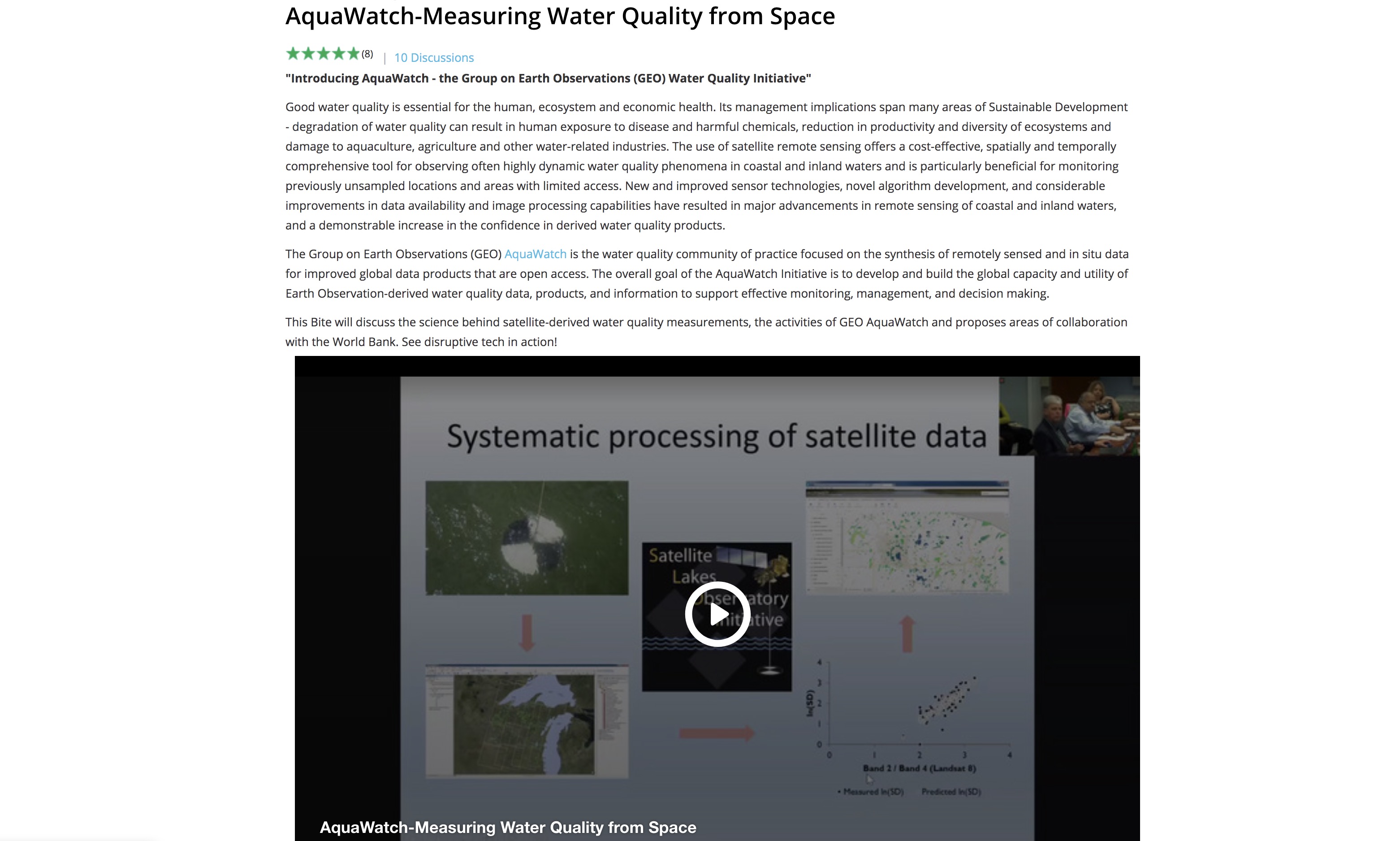
Group on Earth Observation (GEO) AquaWatch is a community of water quality practices that focus on improving and providing global access to water quality products by combining remote sensing data and in situ data. Their goal is to build global capacity and provide relevant and cost-effective water quality products derived from Earth Observations that can support effective monitoring, management, and decision making.
Radar altimetry satellites first launched in 1973 with the GEOS 3 and continues coverage beginning 1991, work on the basic principles of measuring the round-trip time of the radar pulse from the satellite to the sea surface (target). Currently, seven satellites are in orbit that could be applied to measuring sea ice, reservoir water elevations, climate application, and weather forecasting by having information on wind and wave height by having information on signal amplitude and waveform, etc.
Pairing of satellite data with high-resolution monitoring to estimate groundwater depletion across California’s Central Valley
A computational approach developed by Berkeley Lab scientist for groundwater monitoring, pairs high-resolution images derived by satellite with advanced computer modeling to estimate aquifer volume change from observed ground deformation. The approach can be used to estimate the spatial variation of groundwater usage for small and larger regions.
Monitoring well processes can take significant time and resources, particularly in confined aquifers. A novel method is to use InSAR (Interferometric Synthetic Aperture Radar) , which utilizes electromagnetic waves to track changes in the elevation of the Earth's surface to within a millimeter. Scientists accurately measured water-level readings at confined aquifers at three locations but not between sites based on observed changes in the Earth's surface at three of the sampling locations.
Subscription Services: There is an increasing trend for private sector firms to offer data from private sources (e.g. high-resolution satellite images) or analytics from proprietary algorithms on free data (e.g. using machine learning) as paid subscription services for users. This Data as a Service approach will become more and more popular to leverage cloud service and interoperability to allow users to mix a combination of free and such subscription services for their use in visualization or further analytics to obtain insights for decision support. These currently exist for a range of earth observation (e.g. Maxar,Airbus, Earth-i), climate, weather (e.g. Tomorrow, aWhere), and water related services and will probably include more offerings on groundwater as well.
Surveys: There are a number of ways to use survey techniques on the ground and from the air to be able to gather data that is relevant for groundwater management.
Helicopter-borne geophysical surveys are becoming increasingly powerful ways of seeing the unseen at scale by helping map geophysical aspects even 600 m below the surface. These Heliborne Transient Electromagnetic Method (HTEM) products used to be popular for oil exploration but are now being used for aquifer mapping in countries like India.
FRESHEM Zeeland (FREsh Salt groundwater distribution by Helicopter ElectroMagnetic survey in the Province of Zeeland) is a project to determine freshwater saltwater interface and at what depth. Helicopter fitted with an electromagnetic system that measures conductivity levels in the subsurface and the groundwater. Groundwater conductivity is an indicator of the amount of salt level. The information will allow farmers to determine the most promising location for crop water infiltration.
Unmanned Aerial Vehicles (UAVs) or Drones are also becoming extremely popular to do quick surveys of smaller areas including related to groundwater , although there are issues with very restrictive local regulations in some parts of the world. They can be fitted with not only the normal optical camera sensors (which can also yield high-resolution digital elevation models) but also carry specialized sensors (e.g. infra-red, LiDAR, and even microwave) to help generate additional information of relevance to groundwater (e.g. on soil moisture, crop health, water quality in contaminated sites , etc.).
360o cameras provide spherical imagery that is useful to have interactive videos of field areas (try dragging the video above) and also include other visual and interactive elements.
LiDAR (Light Detection and Ranging) is now also available in mobile devices (e.g. some recent smartphones and tablets) and provide an excellent way to do surveys with spatial scanning by basically taking videos that can also have spatial information so that this draped information can be used to create augmented and virtual reality models for collaborative work and measurement on simple or complex digital devices.
Traditional sampling of water (e.g. to determine water quality parameters) has also benefitted from advances in field test kits, laboratory equipment, and emerging analytics. The International Atomic Energy Agency (IAEA) has pioneered the development of nuclear techniques that can be used for various aspects of water management.
As part of collecting data, it is useful to develop a Data Catalog with basic metadata about the data (e.g. source, age, status, format, accessibility, contact information, etc.) to allow for a systematic discussion on what data could be public domain and also to establish the vintage of the data and initiate or scale-up the process of converting the data into public or private online services and establishing a Data Services Catalog.
Analyzing Data
GIS Systems: There are a number of popular software that have been developed for undertaking GIS, remote sensing or other spatial analysis. Spatial tools for forestry management are included in commercial or open source Geographic Information System (GIS). Commercial GIS software has license restrictions, does not publish the underlying code and charges a licensing fee, but is often better streamlined. Open source GIS software publishes the underlying code, has less restriction on licensing and is free to use for commercial purposes, but is often less streamlined. An illustrative (but non-exhaustive) list of some popular open source and commercial software that can support forest management (e.g. spatial analysis, visualization, integration of GPS and other field data, etc.) include:
- Google Earth is a very popular way to get free 3-D high-resolution spatial perspectives on any watershed around the earth. It can now be accessed directly in a Chrome browser at http://earth.google.com or downloaded as a desktop version Google Earth Pro at the same site. It allows easy visualization of high-resolution satellite imagery timeseries draped over a 3-D model of the earth and also allows integration of GIS, animations, photos, videos, 3-D models, or other objects into the visual experience, along with fly-throughs of watersheds that can be shared as links or video files.
- Quantum (QGIS) GIS is a free open source program licensed under GNU Public license, QGIS is user friendly and provides a lot of documentation for beginners, it is also one if not the most widely used open source GIS software. QGIS is regularly updated and the code is maintained by a large group of developers. Furthermore, other programs on the list can be added to the QGIS toolset. QGIS can read most vector and raster file formats as well as all the common geodatabase and web map services. QGIS composer can produce maps from various layers.
- System for Automated Geoscientific Analyses (SAGA) GIS is a free open source program licensed under GNU Public license. SAGA GIS is a spatial modeling GIS program for intermediate to advanced users in spatial modeling. Users should note that SAGA GIS could be used as part of QGIS or R. SAGA GIS’s strength is in spatial statistics analysis, namely spatial sampling, interpolation and modeling. All SAGA tools can be used to predict forest fire as well as forest health risk indicators.
- Geographic Resources Analysis Support System (GRASS) GIS is a free open source program licensed under GNU Public license. GRASS GIS is for advanced users, preferably with experience in GIS and image processing. GRASS GIS is best used for raster analysis. GRASS computes various raster analyses such as Leaf Area Index (LAI), Normalized Difference Vegetation Index (NDVI) or forest fragmentation analysis.
- R + spatial packages (sp, rgrass7, raster, rgdal, spdep, rgeos) is a free open source program licensed under GNU Public license. R is a statistical scripting environment and includes many geo statistical analysis packages. R has a steep learning curve and is for advanced users with experience in GIS, spatial data analysis and python or another language. Albeit extremely versatile, R strength lies in script automation and statistical analysis. Shiny provides web-based support for R.
- IDRISI is a popular image processing software with a suite of associated tools primarily for raster data analysis.
- Environmental Systems Research Institute (ESRI) is the industry leader for commercial GIS systems (e.g. ArcGIS), used in over 350,000 organizations around the world. They have cutting-edge applications including cloud-based systems and also have some free online GIS viewers and open-source software .
- Hexagon have a range of commercial geospatial software (e.g. ERDAS IMAGINE, GEOMEDIA) that are popular for remote sensing and GIS use.
- Harris has a number of products such as ENVI that are very popular for remote sensing analysis.
- Explore here to get more of a flavor for the large number of firms and open-sources and commercial spatial analytical products that could be useful in watershed management.
There are a number of tools that are revolutionizing work on groundwater data:
- Open Source Tools are increasingly becoming important for scaling-up groundwater analytics globally. An example is the Groundwater Level Mapping Tool built on the Tethys platform.
- Machine Learning is a rapidly-evolving artificial intelligence discipline that helps systems to learn without being explicitly programmed – i.e., which can adapt the programs when exposed to new data. To improve Transboundary water management , there are a range of tools based on Artificial Intelligence techniques, such as machine learning and deep learning that that are becoming available for the efficient management of these watersheds and aquifers. Current and accurate information systems that provide water availability and demand can help to increase the accuracy of models to determine the impacts of potential changes in the management and use of shared watersheds and aquifers. Currently being piloted at the Ramotswa Aquifer in Southern Africa , it is expected that AI will enable improved databases to reveal patterns for water sustainability, facilitating improved management and contribute to harmonized policies.
- Virtual Reality or Augmented Reality may look like science-fiction now, but at the rate at which these technologies are being deployed, it will be relatively soon when one can visualize and interact with watershed development and climate scenarios in a completely different way than we currently do.
- Cloud Computing such as Google Earth Engine is a radically new approach to spatial analysis, combining a growing catalog of free, public-domain satellite imagery and geospatial datasets with extremely powerful cloud computing and collaborative platforms. Some Google Earth Engine applications that are particularly interesting from a watershed perspective include:
Modeling:
There are a range of modeling software relevant for groundwater systems. Some of the more popular ones for illustration include:
- MODFLOW from the USGS is a free and very popular groundwater modeling software.
- SUTRA , also free from USGS, is a more complex model for 2D or 3D Saturated Unsaturated, Variable-Density Goundwater flow with solute or energy transport.
- Visual MODFLOW is a commercial software for simulating groundwater flow and contaminant transport.
- SWAT and its online version HAWQS are very popular watershed models that also include groundwater-surfacewater interactions.
- GWWebFlow is a browser-based groundwater model viewer designed to allow users to easily explore model inputs and outputs for published and approved USGS models such as MODFLOW family of models, including MODFLOW2005, MODFLOW-NWT, MT3DMS and SEAWAT.
Visualizing and Decision Support
Online web services (including spatial data using OGC standards) and open data APIs are ushering a revolution of interactive dashboards to visualize data and analytics related to groundwater.
The UN (including UNESCWA) has been working with IGRAC and others to develop a UNESCO-IHP Groundwater Portal. The GGIS is an interactive portal for sharing data and information on groundwater resources around the world. It gives access to map layers, documents, and well and monitoring data. It also contains several thematic map viewers. There are also a number of sites that provide information globally on water points and their status but the information is often patchy.
The World Bank has also been helping improving awareness about relevant free, public-domain water related data through its initiatives such as the Water Data Portal, HydroInformatics Data Platform , and Water In Agriculture Data Platform . For the Mashreq Region, a Mashreq Water Data Platform has been developed.
The groundwater component of the Transboundary Waters Assessment Programme (TWAP) provides aggregated information for the main transboundary aquifers and Small Island Developing States (SIDS). The data that has been made available in the TWAP Groundwater Information System(link is external) includes core indicators, encompassing the hydrogeological, environmental, socio-economic and governance dimensions of the systems.
A partnership of the UNEP, Google, and European Commission’s Joint Research Centre (JRC), together with NASA, and the Group on Earth Observations (GEO). Fresh Water Ecosystems, provides accurate, up-to-date, high-resolution geospatial data depicting the extent freshwater ecosystems change over time. Google will periodically produce geospatial maps and data on water related ecosystems, using massive parallel cloud computing, the open access format of the Fresh water Ecosystems a will drive more action in into protecting and restoring freshwater ecosystems and for countries to track their progress towards, achieving the Sustainable Development Goal Target, 6.6. water data is available on national, subnational and basin levels.
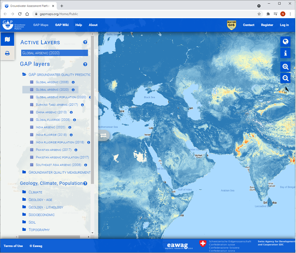
Global Platforms such as from the interactive Groundwater Assessment Platform are useful ways to use statistical approaches to develop global insights on groundwater.
The Sustainable Groundwater Management Act (SGMA) in California has helped spawn a range of groundwater information platforms such as the SGMA Data Viewer . Australia has a detailed National Groundwater Information System . India’s evolving Water Resources Information System also provides visualization of groundwater data for the country.
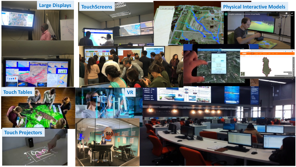
There are a number of new ways of visualizing groundwater data. These can include interactive web portals, customized desktop or mobile Apps, Augmented Reality/Virtual Reality, or hybrid methods such as Tangible Landscape.
The iRain Mobile App is designed to facilitate citizens’ involvement in collecting local data for global precipitation monitoring. It allows users to visualize real-time global satellite precipitation observations, track extreme precipitation events worldwide, and report local rainfall information using crowd-sourcing functionality of the App to supplement the data. A useful feature of iRain is that real-time rainfall observation data can be easily shared through social networks such as Facebook and Twitter.
The SENSEI visualization tools from CSIRO is an advanced in-situ sensor system that gives mining operators and water managers reliable real-time data to monitor and manage groundwater impacts efficiently and faster than ever before. The SENSEI system can measure multiple chemical and physical characteristics simultaneously, can operate off-grid at remote sites and survive long-term in extreme environments.
MWater Is an open access customizable application, for monitoring WASH. The involvement of investors allows features and dashboards to be offered for free to the public.
The AHA app is designed with safety in mind and helps employers identify expected hazards in each activity involved in the process such as exposure to biological and chemical hazards while opening well heads and taking water level measurements with sampling devices. For each potential hazard listed, there are recommended controls for minimizing the risks by increasing safety in ground surface activity and pumping and sampling methods. With this app, operators can identify barriers to taking field measurements that exist at the site location and expand hazard communications in order to foster a safe environment that emphasizes the health and safety of workers.
E-packaging of the data into interactive data and analytics dashboards can be customized for different users. Data can also be integrated into interactive documentation such as this e-book or interactive storymaps that allow complex information to be organized in a manner that allows those interested to do “deeper dives” into the data, analytics, or case studies. They are usually accessible on any digital device with internet connectivity such as desktops, laptops, tablets, smartphones, touchscreens, etc. and allow responsive design sites that leverage this new world of global data services. They also allow for updating the information centrally and reduce the costs of development and maintenance.
Decision Support Systems are often developed to provide an integrated interface into the data, analytical, and visualization systems to support scenario analysis or other planning and operation related decisions.
Institutions
Institutional Infrastructure
Groundwater-related institutions would require appropriate institutional infrastructure to be able to integrate technology effectively into their business processes. This will include the need for appropriate equipment (e.g. computers, smartphones, displays and other tools, videoconferencing), furniture, and connectivity to enable people to work effectively to access, visualize, share, and discuss relevant groundwater data.
Capacity-Building
There is a need to build capacity at all levels to improve groundwater management. This can range from government agencies tasked with water management and related sectors to communities on the ground (e.g. the barefoot hydrologists in India and their next generation coping with the complex institutional challenges of groundwater management ).
There are many examples of the use of modern technology and techniques to get regional perspectives (e.g. global work by USGS , IGRAC, or FAO, work in Africa and South Asia from the British Geological Survey , or work by BGR ).
The Mashreq region can build on global good practices that have evolved in community involvement in groundwater management. One of the earliest attempts was in the form of development of COTAS in Mexico for aquifer management with their own governance structure .
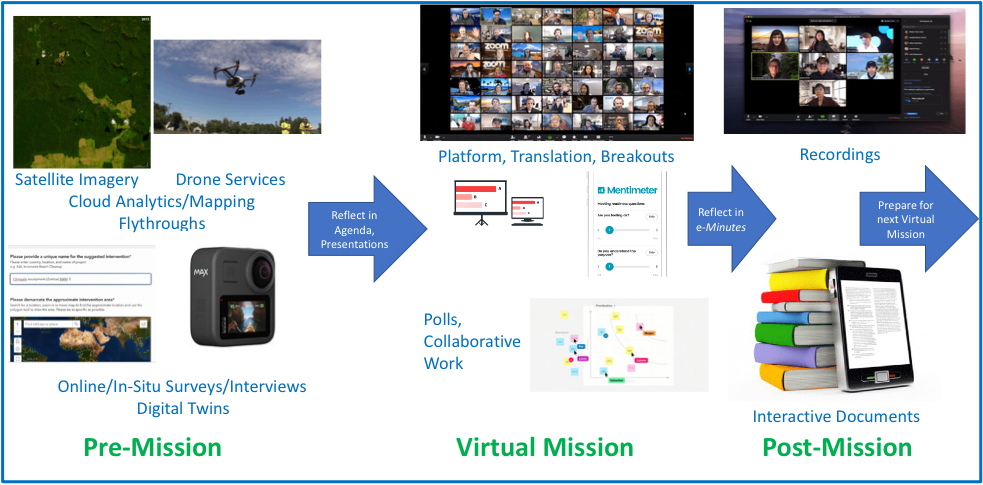
Technology can also be used to support Virtual Missions for institutions – this is not only for the current travel constraints during the global COVID-19 pandemic but also for improving efficiency in leveraging technology in the future. In particular having “ digital twins ” of key aquifers could leverage systems for continuous monitoring and collaborative decision-making.
Policies & Instruments
There are a range of policies and associated instruments that can leverage (and better enable) technology to support groundwater management.
A critical need is to establish an enabling policy framework for public domain access of relevant groundwater data (especially collected in-situ by government agencies) to facilitate its use to improve awareness, support collaborative open research, and improve transparency. California has probably been at the forefront of these approaches through the far-reaching Sustainable Groundwater Management Act that also requires and facilitates data collection, sharing and use.
Standards for data are important to ensure interoperability. For example, the Open Geospatial Consortium (OGC) has a range of standards for services including one specifically being developed for groundwater . Open APIs are publicly available application programming interfaces which provide developers with programmatic access to a proprietary software application or web service. They allow developers, to access backend data that can then be used to enhance their own applications. APIs such as the Floodizer flood detection API , a cross browsers REST API which get a JSON input with a still photo (as base64 encoded string), containing flooded areas and returns a JSON string which contains predictions of the input photo regarding the probability of a flood.
The public, private, and CSO organizations are working together to improve urban groundwater management in large cities such as Bangalore and Chennai (the first city in India that mandated rainwater harvesting). Western US states such as California and Arizona have long histories of trying to improve groundwater management working with a number of stakeholders.
The Regional Knowledge Hub provides an interactive, open access, online platform for accessing regional datasets, information and analysis related to climate change and water resources in the Arab region. It provides access datasets and maps from the RICCAR regional climate modelling, hydrological modelling and vulnerability assessment outputs for specific climate change projections, scenarios, time periods and scales of analysis. It has tools for generating customized maps, downloading geospatial datasets, and exporting outputs in different formats.
Payments for Environmental Services ( PES) where farmers and landowners are paid for environmental services, this approach was pioneered by Costa Rica and has become particularly common in Latin America.
Mexico has the largest such program in the region, with over 2 million hectares of forest receiving conservation payments. The program, which is administered by the National Forest Commission (CONAFOR), pays forest communities $10-$40 per hectare per year to conserve forests, depending on the type of forest and the risk of deforestation.
New York City would have to develop a water filtration plant that would have cost, 8-10 billion USD and 250 million USD to maintain. Instead, they purchased thousands of upstream acres to shield a reservoir from pollution and improve economic development in the upstream area.
China today is looking forward to investing in new ideas to improve water quality and supply. Its “eco-compensation" schemes (a type of Payment for Ecosystem Services) are helping compensate suppliers of ecosystem services for lost income or land use rights through various policy instruments such as fiscal transfer payments, payments for Watershed Services, and improvement of environmental taxes and fees. One of its trans-provincial eco-compensation systems carried out in East China is helping protect environment while also promoting the green development of local economy.
These PES schemes could also be adapted to reward activities to promote sustainable groundwater management
Waterchain is using blockchain to create a decentralized water fund to help improve the water quality worldwide. Harnessing the power of crypto capital, the company is creating smart contracts enabling investors to easily select water projects and share in the profits. By deploying token capital ground-breaking technologies and service companies are funded to radically transform the pace of water treatment.
Leveraging the wisdom of the crowd, especially the youth, is a promising institutional approach globally. Across the world, various competitions including hackathons, data jams, blogathon, X-prize, design and other innovation challenges are being organized to develop solutions to the most pressing water sector problems of our times.
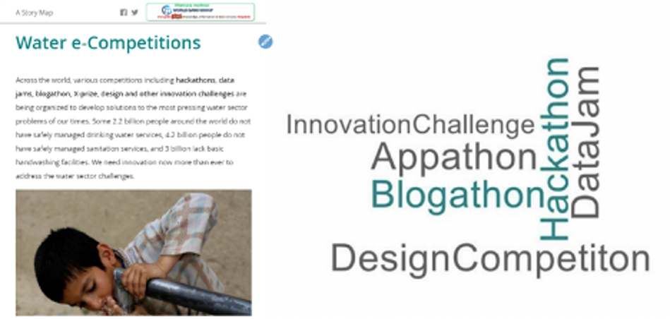
Hackathons are design sprint-like events, that often involves computer programmers and other software development techies, including graphic designers, interface designers, project managers, and others to collaborate intensively on developing software projects and applications. The goal of a hackathon is usually to create functioning software that focus on a specific challenge related to any topic. A group of experts, programmers, college students, or whoever wants to share their knowledge are invited to a workshop to harness their expertise and curiosity to design solutions for identified problems.
Hackathons are flourishing all around the world and have also been used on issues relating to Water (see World Bank Lessons from Water Hackathons ). They are a quick way of bringing innovation to an old-time problem. Solutions come from putting together individuals that bring-up a diverse set of quality ideas that maybe could get years to reach without the proper forum to develop them. It is also very cost efficient since the traditional innovation models often require big investment and longer span of time to reach the solution, while hackathons can lay the first stone of an idea in a few days.
Hackathons are also a great tool to raise concern about the importance of open data. International Data Corporation (IDC) estimates that by 2025 175 Zettabytes of data will be generated annually. But as of now, very little of this data is being analyzed or even used and one of the reasons is the many barriers that researchers encounter when looking for data. Hackathons help stakeholders realize how useful can be data when used to create new solutions.
Investments
Improving Performance
There are a growing range of mobile Apps designed to improve water use for farmers to optimize their existing investments – these are often commercial Apps that provide a service and it is likely that the costs will drop as more data and analytics move to the free/public-domain sphere. Mobile Apps are being used by farmers to operate the pumps (e.g. in the night to reduce water loss and possibly benefit from lower electricity tariffs). New Analytics as a Service Apps such as IrriWatch are being developed to optimize water consumption in on-demand irrigation systems especially those dependent on groundwater pumping.
In addition, technology is advancing on the improved management of watersheds that can include small community-level efforts and green infrastructure (or Nature Based Solutions) as well as traditional grey infrastructure. These could include the use of technology in all aspects (e.g. for earthwork or prioritizing hotspots or planting mangroves with drones, creating floating wetlands for water quality improvement , ultrasonic algal control , moving agriculture offshore , etc.) that can reduce water demand and improve overall surface and groundwater sustainability.
Managed Aquifer Recharge
There are a range of managed aquifer recharge (MAR) investment options that will be a part of serious attempts to manage groundwater depletion by diverting natural water or treated wastewater to infiltrate depleting aquifers. Some of these are being cataloged by IGRAC in theirglobal MAR portal. California in particular has been investing heavily in MAR to improve groundwater sustainability.
Ground water resources around the world are also facing increasing threats of pollution from wastewater from domestic sources and industrial effluents as well as solid waste that changes the chemical and biological properties of water to make them problematic from a human and ecosystem health perspective. This is due to effluents from domestic and industrial point sources as well as non-point sources such as agricultural runoff (e.g., nitrates in groundwater from fertilizers) that results in impacts to people and ecosystems. There are many new options for monitoring water quality using in-situ systems as well as remote sensing. Wastewater treatment is leveraging new technologies using Algae, nanotechnology, and bioreactors.
Innovative technologies are being used to treat water as part of a more circular economy framework that seems to reduce and reuse wastes. Managed aquifer recharge is also leveraging investments in treated wastewater to recharge depleting aquifers. For example, in Orange County, California, the local water district operates the world's largest water purification system, the Groundwater Replenishment system (GWRS) for indirect potable reuse. The system takes highly treated wastewater that would have previously been discharged into the Pacific Ocean and produces high quality water, using an advanced three step purification system consisting of microfiltration, reverse osmosis, and ultraviolet light with hydrogen peroxide. 100 million gallons (379,000 cubic meters) of high-quality water is produced every day, which meets or exceeds state and federal standards for drinking water, and uses it to recharge groundwater aquifers.
Solar Pumping
Solar Pumping is becoming increasingly popular in arid areas with high solar potential and given the rapidly dropping costs of solar energy. This is both useful to support poor communities with energy access challenges and a challenge as it may further exacerbate water scarcity due to overpumping.
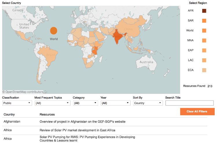
Even though solar water pumping is ready for mainstreaming and has started to take off in some parts of the world, its benefits are mixed to communities, governments, and development institutions. This online repository aims to raise awareness about the technology and provide resources that help incorporate it into operations. Currently, the repository contains more than 260 resources from all regions where the World Bank works and covers a broad range of issues from technological change to institutional setup.
Significant investments in water conservation are required to reduce water consumption especially in agriculture to improve aquifer sustainability. These often take significant information and institutional activities in addition to water conservation investments over a long time (e.g. Ogallala aquifer ). There are innovative technology-backed schemes developing to incentivize farmers to use water and electricity more efficiency – such as the Pani Bachao Paise Kamao (Save Water, Save Money) Scheme in Punjab.
Technology can also be traditional systems that have been used in one area and may find use in other areas. For example, a subsurface dam or a sand dam are two types of underground dams. A subsurface dam features impervious walls and a trench that penetrates down to bedrock or an impervious layer. A sand dam has a weir has been built along the stream. During a flow event, sand is carried by the river and is deposited into the reservoir, which eventually fills up. This creates an aquifer that is renewed each year temporary aquifer. Every year, during a rain event, the aquifer is recharged. Springshed development can also be supported by improved decentralized managed aquifer recharge.