Case Studies
Case Study: Decision Support System for Watershed Management (Agriculture) in SAR
The Karnataka Watershed Management was to improve the effectiveness of watershed management interventions in rainfed areas in the State of Karnataka by developing innovative and science-based approaches for planning watershed management interventions, increasing stakeholders’ capacities to plan, including by using newly developed tools, and implement plans, and ensuring greater integration between national programs when implementing these plans. The PDO was to demonstrate more effective watershed management through greater integration of programs related to rainfed agriculture, innovative and science-based approaches, and strengthened institutions and capacities. “Watershed management” was defined in the PAD as the integrated use/management of land, vegetation and water in a geographically discrete drainage area for the benefit of its residents, with the objectives of protecting or conserving the hydrologic services which the watershed provides, and of reducing or avoiding negative downstream or groundwater impacts.
The Problem Statement
The project was designed to utilize innovations and pilot new approaches for watershed management, and improved effectiveness and leveraging of public financing of watershed operations. Some of the needs include: i) strengthen ongoing government interventions mainly through technical support and facilitates convergence to address and contribute to deeper and more sustainable improvements in productivity and livelihoods of small farmers in rainfed areas; and ii) improve the effectiveness of public expenditures. Three key needs include: i) better integrate watershed development, agriculture programs, and related research (to help small farmers take up innovations and key schemes, have better access to a range of information tools and support mechanisms, improve value addition, and diversify crop, horticulture and livestock productivity, within their particular farming systems); ii) better understood hydrological dynamics based on good science, and integrated into watershed plans (to help watershed management responses account for downstream effects, and lead to better targeted interventions); and iii) demonstrate more effective convergence of the science-based approach based management, and link them into better planning tools, which would provide a more strategic approach to using government resources).
The Approach
The approach was through i) Greater integration of programs related to rainfed agriculture; ii) Innovative and science-based approaches; and iii) Strengthening Institutions and Capacities.
• Greater integration of programs related to rainfed agriculture. The outcome was achieved through better integration of agriculture, ground water, forestry, horticulture, and livestock activities in microwatershed master plans and the adoption of project-supported science-based data for planning by relevant institution; and
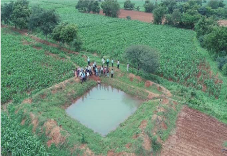
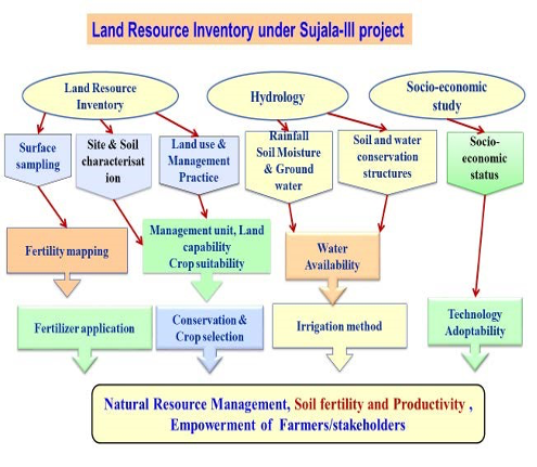
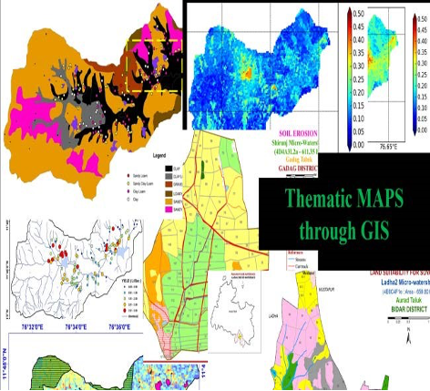
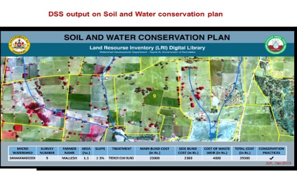
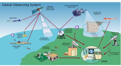
• Innovative and science-based approaches. This outcome was achieved based on-site collection and analysis of micro-watershed-level data, such as variations in soils, landforms, water and land uses. The Land Resources Inventory (LRI) data, together with hydrological data from intensive hydrology assessments at the sub-watershed and micro-watershed levels, cadastral data based on satellite imagery and maps, high resolution images for dozens of thematic layers, dynamic weather data, socioeconomic data, crop information, information on soils and nutrient status, and information on crop prices, were fed into a digitized library, offering nine decision support modules.
• Strengthening Institutions and Capacities. Regular knowledge exchange was undertaken on watershed management, agriculture, and horticulture between the 14 technical partners at the benefit of the project, and support was provided to State departments upon request. This new “lab to land” setting generated farmers’ direct access to, and confidence in, the data on the one hand, and a direct access of scientists to field level information, on the other hand.
Use of Technology
The project deployed the use of Satellite Imagery/Remote Sensing including other integrated technology to achieve the desired results. Satellite-based remote sensing technologies offer high-resolution mapping and visualization. The Decision Support System (DSS) was developed by integrating various LRI data outputs and information from other sources to enable decision making by departments, farmers and other stakeholders.
Results
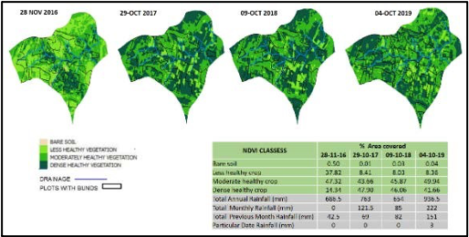
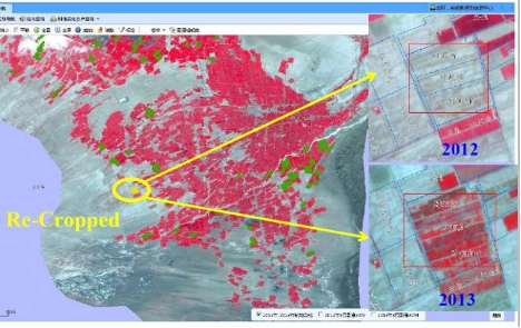
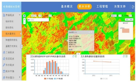
A geospatial analysis revealed that project area shows an increase in vegetation cover (a measure of site productivity) and water availability for cropping based on soil moisture measurements and (Normalized Difference Vegetation Index (NDVI). In addition, the digitized library was available in English and local for registered users, including State departments’ staff and farmers, providing customized real-time information. A public portal was also featured as an interface between the digitized Library, Decision Support System (DSS) tools, and users. The library includes nine DSS modules: (i) soil and water conservation planning; (ii) crop planning; (iii) land capability grouping; (iv) nutrient management; (v) runoff; (vi) farm pond and check dam planning; (vii) crop water requirements; (viii) soil moisture and water balance; and (ix) water budgeting, with 24 datasets available for each plot of land within the micro-watersheds. The datasets include LRI data from the surveyed micro-watersheds, cadastral data for the entire State, high resolution images for dozens of thematic layers, dynamic weather data, socio-economic data and national census at village level, crop information, soils and nutrient status, hydrology, and crop prices. Geoportal functionalities are customized with COTS software, spatial and non-spatial databases are integrated, precise thematic maps and report generation functions are available for users, and measurement tools are in place. The library is linked to real-time updates on weather forecast, market prices (from the GoK Agriculture Produce Market Committee), official land records and census information sources through a built-in migration tool. For an animated description of the LRI and digitized library Sujala III Project
Case Study: Decision Support System for Watershed Management (Water) Turpan- Xinjiang China
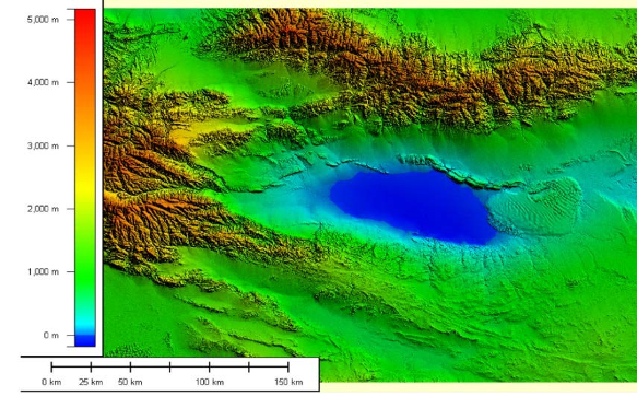
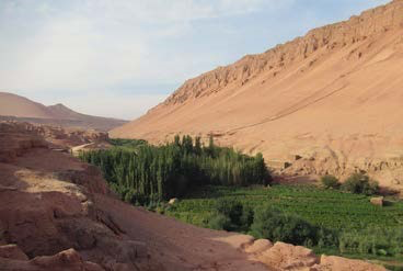
The Xinjiang Turpan water conservation project demonstrated the application of the remote sensing (RS) technology to combat water scarcity with a sustainable approach through ET management. The project was designed to reduce water scarcity in Turpan-Xinjiang area of China. The Turpan Prefecture is located in the eastern part of Xinjiang Region, the area is one of the poorest, most remote and most arid provinces in China. The Turpan Basin covers about 95 percent of the Prefecture. Surrounded by mountain ranges with snow-covered peaks that reach over 5,000 meters in the north, the Turpan Basin also contains in its southern part the second lowest point on earth, 155 meters below sea level - a salt swamp called Lake Aiding. Traditionally, agriculture has been irrigated either from rivers that originate in the mountainous areas in the north and west, or from Karez water supply systems.
The Problem Statement
As a result of widening gap between increasing water demand and limited supplies, the issue of water scarcity is on the rise especially in semi-arid and arid areas of China. With irrigated agriculture accounting for about 65 percent of water use, the project took into account reducing water use in the agricultural sector to accommodate growing demands from other sectors, while at the same time ensuring food security for a growing population. The project development objective (PDO) is to mitigate the risk of flooding, reduce groundwater overdraft, increase industrial and domestic water supply, and raise farmers’ income from irrigated agriculture in the arid Turpan Basin of Xinjiang Uygur Autonomous Region. The PDO is to is to mitigate the risk of flooding, reduce groundwater overdraft, increase industrial and domestic water supply, and raise farmers’ income from irrigated agriculture in the arid Turpan Basin of Xinjiang Uygur Autonomous Region.

The Approach
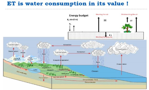
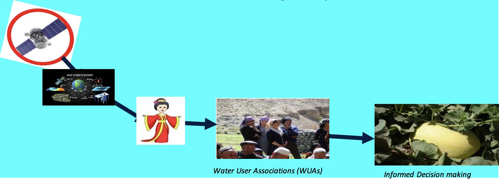
The project utilizes both top-down and bottomup approach. Important top-down activities include establishment of laws, policies, regulations, standards and water allocations, while bottom-up activities include working with counties and townships, villages and individual water users, to achieve sustainable utilization of water resources and increase water productivity. The specific approach elements include: i) ETbased Integrated Water Management in the Turpan Basin; ii) Increase of Upstream Storage Capacity; Water Savings in Irrigated Agriculture; iii) Preservation of a Karez System; iv) Strengthening Institutions and Capacities. The approached combined both model technology such as earth observation (satellite Remote Sensing) and traditional practices such as installation of Water-Saving Irrigation Technologies through drip irrigation, canal lining, low-pressure systems, etc.; and shift in cropping pattern I.e., shift from high-water using, low-value crops to high-value, water-saving crops. In addition, the ET-based Integrated Water Management took into consideration: i) Water Accounting at the river basin level; ii) Remote sensing (RS) ET-based Dynamic Irrigation Planning Tools; iii) ET Application and Monitoring System which links the RS ET Data Production System to WUAs and farmer households to monitor and control water use; and iv) the establishment of ET Management Information System, which is now being used by staff from Turpan Municipal Water Bureau for their daily work for integrated water resources management.
Use of Technology
ET management is an effective and cost-efficient instrument for sustainable water resource management and development. Through the project traditional water measuring facilities were replaced with the RS-based ET measurement to control water consumption. The project establishes and develops a robust, integrated water consumption management approach, consisting of (i) Water Accounting at the River Basin Level; (ii) ET-based Dynamic Irrigation Planning Tools; (iii) RS ET Data Production System; (iv) RS ET Application and Monitoring System; and (v) Office Application and Information System; for achieving balanced environmental and economic sustainable development in arid regions that have a history of unsustainable water management conditions.
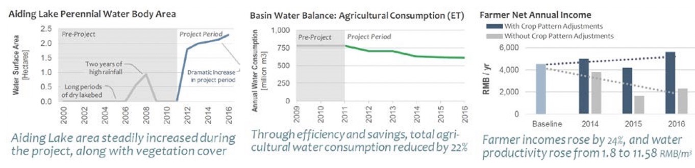
Results
The project contributed to (a) fundamentally changing the economic growth pattern of the Turpan Prefecture from its current reliance on the severe overexploitation of groundwater resources of the Turpan Basin, with devastating effects on the fragile oasis ecosystems, to a more sustainable basis of sound integrated water resources planning and management; and (b) showcased an innovative approach to basin water management that allows for the conservation of water resources while contributing to an increase in agricultural water productivity, measured in terms of ET. The use of innovative technology such as combining RS and ET management provided for the increase in water productivity (or water use efficiency) from 0.80 yuan/m3 to 11.58 yuan / m3, which increased farmer agricultural net incomes from RMB 4,742 Yuan in 2012 to RMB 11,266 yuan in 2016 and contributed to the ecological restoration of Aiding Lake of the Turpan Basin. Farmers in Turpan now grow more economically valuable crops and meet their water needs. Furthermore, the project demonstrated the need to integrate groundwater management with irrigation water use, and physical infrastructure. Through the project, the Karez System is Preserved as clean/clear water now flow from the Karez system to the surrounding. For project sustainability, 43 Water Users Associations (WUAs) were established with members receiving relevant trainings; six staff including two RS ET management professionals were deployed into the municipal water bureaus; and watershed management Information System, developed and used by staff from Turpan Municipal Water Bureau for their daily work for integrated water resources management.
The Land Resource Inventory seems to be a valuable tool for developing and maintaining a knowledge base to manage watersheds effectively and promote convergence of activities for agencies. It can also help local users, including water user associations and farmers.
Institutions & Policy
There are invariably many institutions with fragmented and overlapping mandates in different parts of the watershed. These include institutions at different levels (e.g. regional basin organizations in the case of transboundary watersheds, national/state/local government levels, utilities, community groups) as well as across sectors (e.g. environment and forests, agriculture, irrigation, dams, hydropower, soil conservation, fisheries, tourism, water supply), and types (e.g. government, private sector, academia, Civil Society Organizations, community user groups/farmer organizations, etc.). Most of these are organized by administrative or other boundaries that have little to do with hydrologic boundaries that determine watersheds, sub-watersheds, or micro-watersheds, although in some cases, there are organizations (e.g. basin boards) or at least institutions (e.g. catchment committees) that are set up to consider the watersheds in a more holistic perspective and coordinate with the other key stakeholder groups in the watersheds at different scales.
The institutions in watershed are faced with pressing governance challenges, so there is strong need for various capacity building initiatives. Capacity building at different institutional levels mentioned above can be achieved through both traditional routes (e.g., customized graduate programs, specialized courses, workshops/training) as well as more innovative paradigms (e.g., internship programs, distance learning, interactive online knowledge, virtual helpdesks, enhanced use of automated systems, collaborative workspaces, and frequent virtual interactions). This could help improve links to global good practices and collaborative research within the region and with partners around the world. Various public reforms could also be undertaken including increasing public data accessibility and transparency, improving regional collaboration, and providing a facilitating foundation for protecting and managing ecosystem services. Institutions must have shared vision, technical capacity, meaningful stakeholder engagement and collaborations/partnerships for better watershed management.
Global: Various global organizations such as WOCAT, NASA, UNCCD can help the region in ensuring sustainable land management, land degradation monitoring and combatting desertification, respectively. Global partnerships such as CGIAR can help in sustainably manage natural resources and in increasing food security through its research-based policy solutions. Its research institute IWMI helps provide water solutions for sustainable, climate-resilient development whereas IFPRI provides solutions to sustainably reduce poverty and end hunger and malnutrition in developing countries.
Other global efforts such as Convention on Biological Diversity also aims to help address various challenges associated with watershed management. Chapter 13 of its Agenda 21 “Managing Fragile Ecosystems-Sustainable Mountains” is a significant step for realizing the resource potential of mountains. The agenda indicates the necessity to promote and integrate watershed development approach giving due regard to local opportunities and their livelihoods.
Regional: Regional organizations such as SAARC (South Asian Association for Regional Cooperation) can play a vital role in strengthening collective self-reliance, promote active collaboration and mutual assistance among the constituent countries for better watershed management in South Asia. ICIMOD, an intergovernmental knowledge and learning center can provide hands-on research and piloting of solutions, to policy implementation with governments, to mountain advocacy on the global stage. Regional initiatives and programs (e.g., the World Bank Financed Climate Adaptation and Resilience CARE project for South Asia ) can provide a regional perspective and professional networks on some of the relevant issues.
National: The national and sub-national institutions reflect the level of federalism in the countries of the South Asia region with institutions across sectors that need to work with each other at Central, State/Province and lower levels. Several initiatives have also been taken at the national level such as India’s Water Resources Information System (WRIS), which acts as a central information repository of water resources and related data for better planning and water resources management strategy. Nepal’s Water User Associations (WUAs) aims at better utilization of water resources for collective benefits through its operation and maintenance of water resources development projects.
Local: At local stakeholder level – e.g., at village or district levels, capacity building is a significant constraint. This can be solved through improved automation, innovative technologies and better local coordination, consensus-building, and decentralized management of water using the principle of subsidiarity where possible. Some countries or states/provinces have also encouraged the development of institutions such as water user associations or catchment committees to support more integrated watershed management.
Also, as discussed in the cross-cutting challenges, exchange of available data on the watersheds is quite crucial between the countries in the region which usually is kept hidden due to archaic policies and mindsets. Accelerating technological progress has provided better, faster, and cheaper data and analytic services, paving the way for whole new world of opportunities for stakeholder countries to benefit from open data access.
There are many opportunities to leverage new technologies and processes to build the capacity of institutions to better plan and manage activities in an integrated watershed context.
Policies and Instruments: There are also a number of policies and instruments that can be used to improve watershed management.
- Payment for Ecosystem Services/EcoCompensation
- Open Data Policies
- Water and land rights (including tradable water rights)
Payment for Ecosystem Services
Payment for Ecosystem Services
Consider a landholder deciding whether to clear a plot of land that is currently under forest for use as pasture. If he should decide to retain the forest, he would be able to collect fuelwood and timber, and perhaps some other non-timber forest products. This would generate a steady, but often not very high flow of income for his family. If he should decide to clear the forest, he would incur the costs of clearing it, but also perhaps generate some income from selling the resulting timber. He would then receive a flow of income from using the land as pasture, in the form of income from increased sales of milk and animals, or own consumption of these products. For the landholder, the critical question is whether the benefits he receives from forest are higher or lower than those he would receive from converting it to pasture.
Clearing the forest, however, also has a number of other effects. It affects hydrological flows, often leading to greater runoff, reduced infiltration, and higher erosion, which in turn often increase the risk of downstream flooding, make water flows more irregular, reduce water quality, and fill up reservoirs with silt. It also reduces biodiversity, and releases carbon into the atmosphere, contributing to global climate change. Regulating hydrological flows, conserving biodiversity, and sequestering carbon are all examples of environmental services provided by forests. Cutting down the forest results in the level of these services being reduced.
Individual landholders, however, generally do not benefit from these environmental services. Hydrological services benefit people further downstream, sometimes a considerable distance away (spatially, but often also economically and socially). Carbon sequestration and biodiversity conservation benefit the entire global community. From the landholder’s perspective, these ecosystem services are externalities, which he receives no benefits for providing, and is not penalized for not providing. Because these environmental services benefit others, the landholder will not take them into account when making his land use decision. The value of retaining the forest will thus appear much lower than it really is, making it all the more likely that the value of pasture will appear to be higher, and the forest will be cleared. Note that the problem is not that the landholder is unaware of these other benefits—it’s that even if he is aware of them, he does not take them into account because they are not benefits for him and his family.
In many cases, the potential income for landholders from pasture is higher than that from forest, and so the choice is made to clear the forest.
Over the years, there have been many efforts to address this problem. Many have relied on compulsion. Many countries have laws banning deforestation, either everywhere or in particular areas such as riparian areas. These laws have proven largely ineffective, which is not surprising, given that landholders have strong economic incentives to disregard them. [other types of efforts, ICPDs etc].
Payments for Environmental Services (PES) are a new approach to the problem of externalities. Rather than attempting to solve it indirectly, it addresses it head-on by giving direct payments for land use practices that generate positive externalities.
PES definition
PES is sometimes defined very widely, to encompass virtually any tool that uses economic incentives for conservation. We use here a narrower definition of PES: Payments that are conditional on managing natural resources in ways that generate benefits for others.
The two critical aspects of this definition are:
§ Conditionality: This is the critical aspect of PES. Payments are not made ex ante, but ex post. They are not a subsidy for reforestation, for example: they are a payment for having reforested. In this, PES attempts to mimic a market mechanism: when farmers produce crops, they are paid only when they deliver those crops to buyers.
§ Generate benefits for others: The primary purpose of PES is to address externalities: to undertake activities on their land that benefit others, such as conserving or restoring forest cover. These activities may also benefit the landholders, but usually do not—or, at least, not enough to justify their adopting them spontaneously. If that were not the case, there would be no need for PES.
History of PES
Types of PES programs
There are two important classifications of PES programs: according to their purpose, and according to their financing source.
Conservation-oriented or restoration-oriented
The most common use of PES has been to conserve forest. The basic rationale here is that landholders receive only a fraction of total forest benefits, making it likely that alternative land uses are more attractive. PES provides a payment that makes forests more attractive to landholders, as shown in Figure 1.
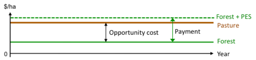
Figure 1: Using PES to conserve a forest
This application requires verifying that forests have indeed been conserved to an agreed standard (for example, by specifying a minimum level of forest cover). Verification may be done by field visits or by using remote sensing imagery, depending on the scale of the plots to be monitored.
Payments in this case must usually be made indefinitely: as soon as payments cease, the alternative land uses will once again be more attractive to landholders than forests. This has important implications for how such programs are financed and for their institutional arrangements. In particular, such payments cannot be financed by donors (except temporarily). Note that indefinite payments do not necessarily imply that PES contracts are of very long duration. The typical arrangement is for a renewable 5-year contract. This keeps down transaction costs by not requiring annual contracts while allowing periodic re-negotiation to take into account changing economic conditions and understanding of environmental services.
Most of Costa Rica’s PPSA program and Mexico’s entire PSAB program focus on conservation.
There have been few rigorous impact evaluations of such programs. The only such evaluation to have included a randomly-assigned control group, of the Budonga-Budoma PES program in Uganda, found that PES reduced deforestation substantially. Evaluations of other programs have relied on matching approaches. An evaluation of Mexico’s PSAB program found that it reduced deforestation among participants by about half, but that the highest deforesters did not participate. Evaluations of the Costa Rica’s PPSA program have found a range of results, with additionality being as low as 1 percent in some studies to as much as 17 percent in others.
In recent years, PES has also been increasingly used as a tool to restore degraded habitats, for example by reforesting them, or by inducing adoption of environmentally-friendly productive practices such as agroforestry or silvopastoral practices.
The most common such use has been to encourage adoption of sustainable, environmentally friendly productive practices. These are assumed to be more profitable for landholders than current, environmentally harmful practices once they are established. However, high initial costs and the time it takes for the new practices to become more profitable than current practices discourage landholders from adopting them. In some cases, additional obstacles may exist, such as lack of knowledge of the new practices and of how to implement them, or non-availability of required inputs. In this context, a short-term PES program is usually offered, aimed at reducing (but not necessarily entirely eliminating) some of the initial costs to landholders of adopting the new practices, and bringing forward the time at which they break even, as shown in Figure 2. Payments in this kind of PES program are usually finite in time, and often coupled with technical assistance (TA) and other forms of support. Because of their short-term nature, such programs can be funded by donors.
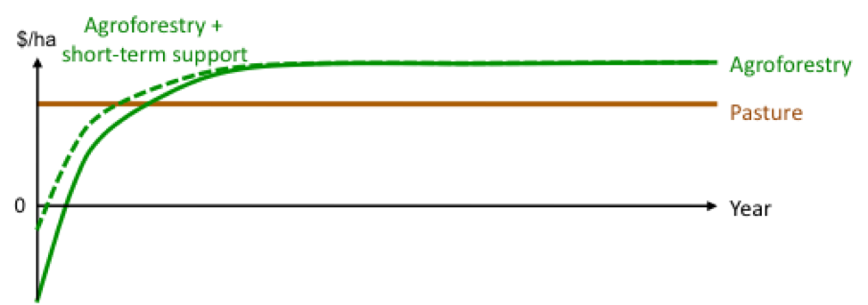
Figure 2: Using short-term PES to induce adoption of an environmentally-friendly practice that is profitable to landholders
The current Colombia Mainstreaming Sustainable Cattle Ranching Project (P104687, effective since 2010, known as GCS from its Spanish acronym) and the previous Regional Integrated Silvopastoral Approaches to Ecosystem Management Project (implemented from 2003 to 2008) both used this approach to restore degraded pastures. Other examples include China’s China’s Sloping Land Conversion Program (SLCP, also known as ‘Grain for Green’), Espírito Santo’s Reflorestar program (supported by the Espírito Santo Integrated Sustainable Water Management Project), São Paulo’s proposed Crédito Ambiental Paulista—Mata Ciliares (CAP-MC, supported by the São Paulo Sustainable Rural Development and Access to Markets Project ), the ‘reforestation’ contract in Costa Rica’s PSA program, the Equitable Payments for Watershed Project (EPWS) in Lake Naivasha, Kenya, and many programs that sell carbon emission reduction credits from forestry activities, particularly those that sought to sell to the Clean Development Mechanism (CDM).
There has been only one rigorous impact evaluation of such a program, of the Regional Integrated Silvopastoral Approaches to Ecosystem Management Project (implemented from 2003 to 2008), which used a short-term PES mechanism to induce adoption of silvopastoral practices. This was the first World Bank NRM project ever to have a control group. The evaluation found that: PES had a significant effect on adoption of silvopastoral practices (PES recipients converted almost half their farm areas to silvopastoral practices); it had high levels of participation by poor households (by some measures, poor households participated to a greater extent than better-off households); and that it’s results persisted four years after payments ceased.
Restoration-oriented PES can also seek to restore areas that are not necessarily productive. They may seek to restore forests or other natural ecosystems, for example, that are either not very profitable to landholders or that cannot be harvested because of legal restrictions (for example, because they are located within protected areas). Figure 3 illustrates this case. As in the case of restoration with productive practices, there is a significant initial cost. Unlike the case of productive practices, however, even once established returns to landholders remain below those of alternative, productive uses. In this case, a short-term payment will be insufficient to induce adoption—or, worse, may induce temporary adoption as long as the payments last, followed by abandonment once the payments cease. Inducing participation in this case requires both fully covering the initial costs and covering the long-term opportunity costs. While donors could finance the initial costs, they could not cover the long-term opportunity costs.
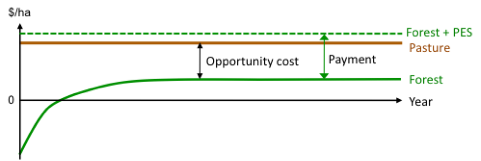
Figure 3: Using PES to induce adoption of an conservation practice that is not profitable to landholders
21. One program that seeks to do this Espírito Santo’s new Reflorestar program, which couples a one-time short-term payment for reforestation, to cover the investment costs, and a renewable longer-term payment to cover the opportunity costs.
As this application of PES is relatively new, there have been no impact evaluations, so its effectiveness is not known at this point.
User-financed vs Government-financed
An important difference within PES program concerns its source of financing.
Ideally, PES would be financed by those who benefit from the services being provided (the service users).
| | |
| A. User-financed | B. Government-financed |


Figure 4. User-financed vs government-financed PES programs
User-financed programs attempt to mimic as closely as possible a normal market transaction. […]
Government-financed programs […]
Examples of PES programs
There are a large number of PES programs in developing countries, particularly in Latin America.
Costa Rica PSA (Costa Rica)
National program, mostly conservation-oriented, mostly government-financed
[figure showing current contracts at any given time, broken down by type of contract]
Espirito Santo Reflorestar (Brazil)
State-level program, mix of conservation and restoration, government-financed
[figure showing difference in payment flows for conservation and restoration]
Silvopastoral Project/Ganaderia Sostenible Colombiana (Colombia)
Restoration-oriented
[figure showing impact of project on land use, env services]
Extrema Conservador das Aguas (MG, Brazil)
Watershed-scale, user-financed, conservation and restoration
San Francisco del Norte (Nicaragua)
Very small watershed-scale, user-financed, restoration, then conservation
China has also made impressive achievements in terms of largely government-financed PES programs called Eco-Compensation schemes at various levels (including across large provinces). This includes a move towards more national regulatory frameworks to support eco-compensation.
China has also made impressive achievements in terms of largely government-financed PES programs called Eco-Compensation schemes at various levels (including across large provinces). This includes a move towards more national regulatory frameworks to support eco-compensation.
Investment Preparation & Operations
There is a need for multi-faceted, multi-sectoral, and multi-level investments to address existing and evolving challenges and benefit from the opportunities available in a watershed.
These investments can include:
- Institutional Infrastructure (for monitoring, institutional strengthening)
- Watershed Investments (nature-based and structural) related to soil and water management, sustainable productivity improvement and climate resilience
- Community Livelihood Improvement (e.g. climate-smart and eco-friendly agriculture)
- Services (e.g. for data, capacity-building, harvest/storage/transport/marketing of sustainable produce)
The need for investments in watershed management are multiple and respond to a variety of objectives. However, there are two main types of investments in watershed management: investments in monitoring systems, for generating information about the status of the watershed natural resources (physiographic, meteorological, hydrologic, land use and land cover, ecosystems, etc.) or intensifying their use (livelihood improvement through rainfed agriculture, livestock production, and forestry). For those investments to be efficient, sustainable and appropriate to the real conditions of the watershed, watershed managers may overcome many challenges, such as the lack of long-term vision and the lack of sound technical support to adequately plan and implement those investments; the absence of adequate, reliable information to effectively diagnose and prioritize the problems and solutions of the watershed; the inadequate maintenance of the investments, etc.
Preparation of a robust investment pipeline includes adequate attention to technical, environmental, social, economic, and institutional aspects whereas to facilitate implementation, adequate technical assistance and M&E would play a key role.
Some of the good practices of linking upstream and downstream impacts and designing investments accordingly are found in the World Bank Nigeria erosion and Watershed Management Project, which provides a good example in linking major interventions at gully erosion sites with broader interventions upstream around soil and water conservation, and land-use practices. Further, the Bank’s Shire River Basin Management Program in Malawi links upstream watershed management interventions with reductions in sedimentation into the Shire River and impacts on downstream hydroelectric generation.
Through its South Asia Water Initiative (SAWI), the World Bank is supporting the region by brokering broader dialogue on inland waterways and informing investment decisions on clean energy, agriculture (food security), and research on other water-related challenges, such as climate change, groundwater management and disaster risk management to deliver sustainable, fair, and inclusive development and climate resilience. The approach is vital for transboundary water governance and to bring economic benefits for the region’s population of 1.8 billion people (SAWI Annual Report 2018-19) .
Intervention at the landscape level to solve reservoir sedimentation at dams in the South Asia Region is gaining traction. Erosion in the watersheds due to deforestation, agricultural practices, and human activity such as road and home construction on steep slopes yields enormous quantities of sediment in the waterways of major basins. This sediment collects in dam reservoirs, effectively lowering dam capacity and necessitating costly operations to remediate or rendering the reservoir useless. A sediment management hub has been developed by SAWI, the World Bank, and the International Hydropower Association to facilitate knowledge dissemination on strategies for effective sediment management.
South Asia Drought Monitoring System (SADMS) is providing weekly maps on draught conditions in the region. Various drought indices have been developed including the Integrated Drought Severity Index, Standardized Precipitation Index, and Soil Moisture Index to provide advanced drought monitoring and assessment information for various purposes. The drought severity maps that are produced on the SADMS deliver continuous geographic coverage from regional to district scale information about drought's effect on agriculture.
Global Environmental Facility (GEF) support forest and landscape restoration globally. GEF supports forest landscape restoration, which is an important part of the RIO Convention. Their project incorporates multiple stakeholder and flexible financing to create jobs, secure livelihoods, and restore degraded lands, ecosystems, and forests holistically.
Nature-Based Solutions
Nature-based solutions are gaining acceptance globally as an investment paradigm that combines traditional grey infrastructure with more green options. Nature-based solutions seek to preserve the ecosystem services nature provides by protecting and restoring natural systems. Well-functioning ecosystems provide a host of critical ecosystem services that support the natural world and human society. These services include provisioning, regulating, supporting, and cultural services. According to the IUCN, nature-based solutions are “actions to protect, sustainably manage, and restore natural or modified ecosystems that address societal challenges effectively and adaptively, simultaneously providing human well-being and biodiversity benefits.” Vegetation and soils, including forests, provide critical provisioning and regulating ecosystem services. Vegetation, including forests and trees, hold soil together, reducing erosion and retaining soil fertility (regulating service) while also purifying water (provisioning service). Vegetation and soils also absorb and hold water, moderating streamflow and reducing inland flooding, coastal erosion and sea-level rise (regulating service).
NBS can be implemented at various scales and for multiple sectors. NBS can be implemented at the landscape level, where whole watersheds or ecosystems are managed, protected, and/or restored to positively impact ecosystem services that deliver benefits to agricultural areas, hydropower facilities, waterways, cities, and coastal areas. At the other end of the spectrum, NBS can be implemented at the local level, either as green infrastructure for stormwater mitigation in an urban area, or green infrastructure installed above a road in hilly terrain to prevent landslides originating from higher elevations. Appropriate NBS mitigation measures may be scale dependent. To understand priority areas for NBS investment, development teams should conduct landscape-level assessment to identify areas external to the immediate project site that may significantly impact the project through landscape-scale natural processes (e.g. erosion and sedimentation). For example, on a single hillslope, NBS may not be effective in isolation, but could be implemented at the hillslope with other risk reduction measures, as well as in the surrounding areas that impact the hillslope.
The Bank has explored the use of NBS in a variety of sectors, including for flood and coastal erosion risk mitigation. The Bank’s Nature-Based Solutions Program , started in 2017, seeks to collate information on NBS used in Bank projects, provide guidance on integrating NBS into future projects, and to mainstream the use of NBS in future projects in DRM and water management. The program has thus far focused on coastal flooding and erosion, river flooding, and urban stormwater flooding. A growing number of Bank projects incorporate nature-based solutions for disaster risk reduction, such as forest-based landslide risk management in Sri Lanka , coastal flooding and erosion in Vietnam , and
urban and river flooding in Senegal . The program estimates that since 2012, 76 DRM projects containing NBS have been approved to target many natural disaster risks, including coastal erosion; flooding (urban, rural and coastal); drought; and landslides. These projects have been implemented through a number of Bank Global Practice areas, including environment; social, urban, rural & resilience; agriculture; water; social protection & labor; and transport & ICT. A synopsis of the Bank’s NBS program is available here.The Bank’s NBS Program has developed a searchable map encompassing projects with NBS components globally.
Bank resources on NBS. Key resources on NBS available through the World Bank’s activity are:
-
Integrating Green and Gray: Creating Next Generation Infrastructure . Washington, DC: World Bank and World Resources Institute, 2019.
-
Nature-Based Solutions for Disaster Risk Management . Washington, DC: World Bank, 2018.
Implementing Nature-Based Flood Protection: Principles and Implementation Guidance . Washington, DC: World Bank, 2017.
Managing Coasts with Natural Solutions: Guidelines for Measuring and Valuing the Coastal Protection Services of Mangroves and Coral Reefs . Washington, DC: World Bank Wealth Accounting and the Valuation of Ecosystem Services Partnership (WAVES), 2016.
The Role of Green Infrastructure Solutions in Urban Flood Risk Management . Washington, DC: World Bank, 2016.
Grow in Concert with Nature: Sustaining East Asia's Water Resources through Green Water Defense . A World Bank Study. Washington, DC: World Bank, 2012.
- Build Institutional capacity for catchment planning and monitoring : Project support development of a catchment planning framework from large scale (around 26,000-41,000 ha) down to village level (less than 500 ha). Broad catchment and sub-catchment management plans covered 133,000 ha across the four priority catchments. The capacity activity provided support to the development of community-based natural resource planning and management system that included social mobilization.
- Rehabilitate targeted catchments: Through the project support, communities engaged a range of soil and water conservation activities to improve land and water management at village level for sustainable land management, including rehabilitation of degraded community forests, targeting an area to be treated of 33,000 has. Activities include support to improved water management through smaller-scale structures built by community members that include stream and water control structures, including check dams and small earthen dams.
- Support Alternative Rural Livelihoods: The project provided support to demand and market driven income-generating activities to gradually decrease dependency on low performance agriculture and unsustainable harvesting of forest products as sources of income. This include: (i) area-specific market demand and value chain transaction support studies; agricultural fairs aimed at identification of and linkages with markets; (ii) development and start-up of commercially oriented alternative livelihoods initiatives of common interest groups (CIG), (iv) finance district level infrastructure including markets places, feeder roads, bridges to access to markets; and (v) provision of livelihood grants.
- Improve Ecological Management . The activity strengthened the management of large natural habitat within the Shire Basin, including: (i) selected infrastructure and capacity building investments and management plans in Lengwe and Liwonde National Parks to increase their long-term revenue flows; (ii) implement of community forest co-management in the Neno Eastern Escarpment and Tsamba Forest Reserves in Neno district; and (iii) support zoning, patrolling and monitoring of the Mangochi Forest Reserve adjacent to the Liwonde National Park.
Many of these projects have pioneered the use of approaches that integrate modern analytics (e.g. using satellite data and decision support systems) with meaningful stakeholder participation.
Payments for ecosystem services is a growing field that provides income streams to support environmental protection and restoration for multiple direct and indirect co-benefits. Public-private partnerships (PPP) in this realm offer opportunities to align interests of communities, government, and private companies around environmental restoration. A recent World Bank project supported a PPP in Ethiopia to improve livelihoods and environmental health through an engagement on watershed development.
Integrated Approaches
A fourth “i” that is often ignored is to find ways to combine the perspectives and tools of the 3Is in a more Integrated manner to support multi-sectoral approaches in a spatial, hydrologic context.
For example, generation of integrated watershed/basin plans at different levels are an excellent opportunity to generate consensus on a longer-term vision for the watershed, and outline a series of actions in a rolling plan (2-5 years) that will need to continue forever as such a plan is never “finished” – just morphed into new decisions that need to be made given new challenges and opportunities.
The generation of these plans will require meaningful stakeholder inputs that can be organized into structured stakeholder consultations that can help guide the analytics as well as benefit from it if appropriate effort is taken to help communicate the complexity of watershed scenario analysis to stakeholder groups and sincerely solicit inputs. These may require comparing various future scenarios (e.g. based on climate, development paradigms such as more nature-based solutions) according to a range of objectives, criteria and indicators as indicated below:
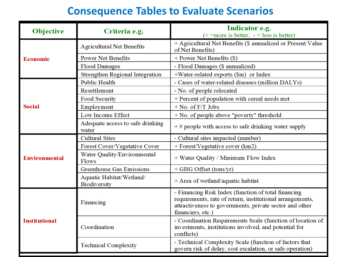
Source: Nile Work & add context – investment prioritization
Sometimes, these are reduced to indices constructed by weighting these indicators, but these are often difficult to communicate (although some like air quality indices have now become well-accepted). Another option is to leave these “consequence tables” of scenarios with actual numbers/rankings and see if the complexity can be reduced by showcasing to decision-makers the big picture implications of various scenarios on key indicators that are more sensitive (e.g. cost, benefits, environmental/social implications, implementation complexity).
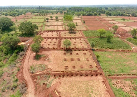
Case Study: India Karnataka Watershed Development (Sujala)
One of the examples of an Integrated approach includes a decentralized interagency organization: In the Karnataka Watershed Development Project I (P067216), the establishment of inter-agency, district level technical teams (under the leadership of the Watershed Department) to provide coordinated support to communities during micro-watershed planning and implementation proved quite successful. This model was replicated in subsequent watershed management programs in the state, financed by the Indian Government. The state also pioneers a holistic approach to Watershed Development through its project Sujala to increase availability of water in seven drought-prone districts of northern Karnataka.
Case Study: Loess Plateau Watershed Rehabilitation
Case Study: Loess Plateau Watershed Rehabilitation
The Loess Plateau is a 640,000 square KM watershed located in northwest China with a population of fifty million people. Soil called loess is highly prone to wind and water erosion. Windstorms have transported material as far as Beijing, which is approximately 500 KM away. Severe rainfall regularly washes away topsoil, causing deep gullies to form. Historically, for thousands of years, farmers have removed trees to grow crops and allowed sheep and goats to graze the area until the area is bare of any vegetation. Through these actions, four billion tons of sediments were conveyed into the Yellow River annually.
Chinese government has been involved with terracing, building dams, reforestation, and providing goats and sheep to improve livelihood with detrimental effects on the environment. For example, the government shipped to the farmers goats and sheep which ate the seedling trees used for reforestation. Since the farmers did not perceive a direct benefit to them, such as edible fruits, they did not take care of them. The lack of vegetation also caused farmers to seek higher elevations with steeper slopes for their livestock to graze on and leave the ground bare.
Site visits by the Government of China and World Bank indicated that farmers on community land were reluctant to make changes because they would not own the harvest. In 1994, the World Bank came across a learning opportunity in Shageduo village when they saw several hectares of walnut trees. Downstream of the walnut trees was a vegetated gorge where the village chief stated that we had to ban and get rid of the goats and sheep for plants to grow, since the livestock was eating the plant seedlings. Due to the complexity of the challenges, it was important that the development approach would need to integrate policies, legal, institutions, and technical know-how to ensure that both incentives and technology were right and cost-effective and could be effectively implemented on a large area of land. The first step is to ensure food security for the farmers on board by ensuring food security otherwise there was no point discussing other aspect of the project.
The wider terraces that allowed farm equipment happened by complete accident since there was not enough labor to build terraces by hand. Larger terraces doubled the crop yield and withstood the effects of erosion after a storm event. Annual grain yields increased by 60 percent from 365 to 591 kg per capita. Machines could complete the harvest in 3-4 days instead of 20 day using an ox. Long term success required distribution of productive lands by consolidation scattered productive plots and each family member would receive 2 mu of arable land per person that was publicly measured to ensure transparency. Farmers received long term leases that ensured they would take care of the land without worrying their land would be taken away. Economic trees were provided by the project with the farmer providing the associated labor. A signed use and maintenance agreement was enforced once the trees were established. Livestock grazing was replaced with penned livestock. New breeds were introduced that produced higher quality milk and wool without the concern of disease. Income tripled over that time. By 2005, grazing was banned in the Loess Plateau region.
At the end of the project in 2005, three million people had benefitted from the project. Soil erosion was reduced on 920,000 hectares of land, and soil losses reduced by 60 million tons per year. By 2008, 240,000 square km of land had been restored. The successful approach introduced in Loess Plateau has since been applied to Yangtze and Pearl River Basin.
Case Study: Malawi Shire River Basin Management Program
Case Study: Malawi Shire River Basin Management Program
This World Bank and GEF financed program sought to improve the framework for land and water management for ecosystem and livelihood benefits in targeted areas of the Shire basin.
The project successfully developed scalable systems and methods to rehabilitate catchments and protect existing natural forests, wetlands and biodiversity in the Shire River Basin. National catchment management guidelines were developed and adopted at the national level and currently used by various stakeholders. Various plans at catchment were developed to guide implementation of community-based land and water management interventions in four priority catchments of upper Lisungwi, upper Wamkulumadzi, Kapichira and Chingale, covering a total area of 129,000 ha (about 5 percent of the basin land area).
Consistent with global best practice on watershed management, the project adopted a livelihoods approach to catchment management by integrating livelihood-enhancing activities - i.e. establishment 80 farmer field schools, provision of enterprise micro-loans for alternative (non-farm) livelihoods, community environmental conservation grants, rural infrastructure for market access (80km of feeder roads, 11 bridges and 13 market centers). The total value of enterprise development grants managed by targeted Group Villages (GVs) reached 620.5 million Malawian Kwacha at project closure. A total of 366 Common Interest Groups (CIGs) were formed, trained and provided with low-interest micro loans (up to US$2,500 each) as start-up capital for various non-farm enterprises. The most common enterprises included goat rearing, piggery, fish mongering, grocery shops etc. In some of the communities, the small initial grants provided have doubled in size as borrowers paid back small loans with interest. Beneficiary data obtained from project M&E database suggest that 446,650 people (compared to a project target of 400,000) directly benefited from the project’s improved land and ecological management, as well as various livelihood enhancing activities linked to these interventions. About 50 percent of the beneficiaries were women. Overall, there is evidence that the livelihoods approach helped to increase farmer adoption of sustainable land and water management practices. At project close, about 77 percent of households within the targeted catchments were reported to be engaged in sustainable land and water management practices, compared to a baseline of 15 percent.
The first project in this program adopted an integrated approach involving the following activities:
Case Study: Ethiopia Watershed Management
Case Study: Ethiopia Watershed Management
The World Bank has been financing a range of programs in Ethiopia to improve watershed projects, including a long series of Sustainable Land Management projects. The Tana and Beles Integrated Water Resources Development Project sought to take a more integrated perspective by supporting the creation of a Tana Sub-Basin Organization and a Beles Sub-Basin Organization as part of the Abbay Basin Authority in order to support multi-sectoral planning and management of the Lake Tana and associated sub-basins. Modern real-time monitoring, including Ethiopia’s first weather radar, was financed along with capacity-building on data and analytics. Investments were supported on catchment planning, soil and water management, deep gully rehabilitation, and flood management. The work on M&E> was significant as it allowed for integration of data from earth observation (e.g. NDVI), in-situ monitoring (e.g. flows, turbidity), and project activity to explore the biophysical impacts of project interventions. The new generation Resilient Landscapes and Livelihood Project and a more recent P4R (Program for Results) operation are expected to further mover the envelope on watershed management in Ethiopia.
Many of these projects have benefitted from cross-learning. For example, the Ethiopia projects benefitted from study tours to the China Loess Plateau and India Karnataka Watershed Projects. The Malawi Shire Basin project team benefitted from some of this and also study tours to Ethiopia. It is useful to improve virtual documentation of the growing lessons from implementation experiences from such programs around the world to continue countries to build on both their own and others’ experiences in watershed management.