Spatial Platforms
There have been many advances in recent decades in Geographic Information Systems and Remote Sensing since the early days of GIS in the 1980s. You can find a quick overview of GIS and remote sensing at this link.
Fresh Water Ecosystems
A partnership of the UNEP, Google, and European Commission’s Joint Research Centre (JRC), together with NASA, and the Group on Earth Observations (GEO). Fresh Water Ecosystems, provides accurate, up-to-date, high-resolution geospatial data depicting the extent freshwater ecosystems change over time. Google will periodically produce geospatial maps and data on water related ecosystems, using massive parallel cloud computing, the open access format of the Fresh water Ecosystems will drive more action in into protecting and restoring freshwater ecosystems and for countries to track their progress towards, achieving the Sustainable Development Goal Target, 6.6. water data is available on national, subnational and basin levels.
Desktop Modeling
Modeling is a way to simplify the processes of reality to better represent the state of current knowledge in terms of inter-relationships across various variables. In the context of a watershed, modeling can be of many types, including:
- Water Balance/Hydrologic Modeling: Accounting for what happens to the hydrologic cycle elements of a watershed in terms of rainfall, evaporation, transpiration, surface flow, infiltration, outflow, etc. in both a pristine watershed and as influenced by anthropogenic factors such as storage, pumping, use, discharge, etc.
The Hydrologic Modeling Method (HEC-HMS), by the United States Army Corp of Engineer Hydrologic Engineering Center, is a computer program that simulates the entire hydrologic cycle in dendritic watershed systems. The program can run in either an event-based or continuous mode. The software integrates several hydrological elements in event mode, including event infiltration, unit hydrographs, and hydrologic routing. Continuous simulations incorporate evapotranspiration, snowmelt, and soil moisture accounting. The program has been used to determine flood frequency, forecast floods, design reservoir spillways, and study erosion and sediment transport.
The SWAT (Soil Water Assessment Tool) model is a basin-scale, water-balanced continuous-time model. The model is designed to determine the impacts of management of water, sediments, and agricultural chemicals in large complex watersheds with varying soil, land use, and management conditions over a long period of time. It has been extensively used worldwide for hydrologic studies, land use change, water quality, and climate change studies.
- Hydraulic/Hydrodynamic Modeling: These tools explore flow in channels and flooding using tools of varying complexity.
HEC-RAS models one-dimensional flow, one and two-dimensional unsteady flow, sediment transport, water temperature, and water quality modeling for a complete network of natural and constructed channels. The program has been used to design hydraulic structures for bridge scour analysis, floodplain analysis, dam break, and levee breach analysis, sediment transportation, evaluation of deposition in reservoirs, and water quality.
- Water Quality Models: These models help explore pollution sources for various pollutants and explore the fate and transport of these pollutants and their implications on the water quality of the streams and further downstream receiving bodies of water.
DELWAQ is the engine for the D-Water Quality and D-Ecology programmes, which is part of the DELFT3D suite. The model can solve a wide range of physical, biological, and biochemical processes such as salinity, chloride, suspended sediments, temperature, dissolved oxygen, phytoplankton, algae growth, etc. The main requirement is a hydrodynamic model, which can be coupled with DELFT3D or TELEMAC, both of which are open-source software.
- Limnology Models: These explore the way lakes behave in more detail.
- Erosion Modeling: These generally use some version of a Universal Soil Loss Equation that models potential erosion based on information such as topography, soils, precipitation, landcover, and land management.
model was developed by the USDA Agricultural Research Service and the USDA Natural Resource Conservation Service created the AnnAGNPS (Annualized Agriculture Non-Point Source) model. ANNAGNPS identifies, measures, optimizes and provides risk analysis for contamination sources located in the watershed. Hydrologic simulations are based on the water balance, and the runoff component is based on the SCS runoff curve number approach. Sediment yield for the surface and stream is calculated using the Revised Universal Soil Loss Equation (RUSLE) and the Hydro Geomorphic Universal Soil Loss Equation (HUSLE), respectively. AnnAGNPS has been used to manage watersheds by simulating soil erosion and the movement of nutrients and pesticides from the land surface to the watershed outlet via the channel.
- Other Specialized Modeling: Watershed modeling can also include very specialized models related to groundwaters/aquifers, energy systems, specialized economic modeling (e.g., game theory), etc.
Modular Flow (MODFLOW) , developed by the United States Geological Survey, is a three-dimensional finite differences groundwater model that is extensively used worldwide. MODFLOW was initially intended solely for groundwater, but the modular nature has allowed for additional capabilities. MODFLOW can simulate coupled surface and groundwater systems, solute transport, aquifer system compaction, and land subsidence, groundwater management, variable-density flow (saltwater), etc.
iMOD is the Deltares version of MODFLOW with a graphical user interface. The program allows grid resolution toggling, editing of subsurface, and scalable which allows for high-resolution groundwater models. iMOD has been applied to density dependent groundwater flow (SEAWAT), water quality (MT3D), and groundwater flow.
- Water Systems Modeling: These usually use either simulation or optimization to look beyond single “projects” such as dams, irrigation command areas, hydropower plants, water supply, etc. and explore these in a larger inter-related systems context (e.g., as a watershed, sub-basin, basin, etc.). Some of these model only bio-physical aspects, but other extend this to include economic, environmental, and social aspects.
RiverWare , developed by the University of Colorado's Center for Advanced Decision Support for Water and Environmental Systems (CADSWES), is a reservoir and river basin modeling tool that enables users to simulate and evaluate various basin operations in both simulation and forecast modes to aid in decision-making. The model employs goal programming and linear programming to optimize each user's set of prioritized policy goals. The program can manage daily and midterm forecasting and long-term planning. RiverWare has been applied to system optimization, water accounting, administration of water rights.
The landscape for modeling is still not very satisfactory with often high costs of development or customization of tools to model various aspects of watersheds. Recent trends to developing more easy-to-use free online tools (some global) give some insight into what is possible in the near future.
There are several modeling tools that are commonly utilized to analyze various aspects of water resources. The more common ones are briefly described below.
Online Analytics
GEE
Google Earth Engine (GEE) is a cloud-based platform from Google provides access to multiple repositories of satellite imagery and geospatial datasets allowing quick and accurate analysis and visualization of large datasets available in the cloud, the datasets include free geospatial data, optical and radar satellite imagery, climate information, digital elevation models, land cover maps and a variety of socio-economic variables.
GBDX, by Maxar Technologies, performs geospatial data analytics at scale in the cloud by processing petabytes of information using your custom or their python script. Users work with all off GBDX imagery in the cloud to obtain insight but do not own the raw data.
ESA Thematic Exploitation Platform (TEP) is a collaborative platform that allows users to extract insights from satellite data without downloading any datasets. TEP has seven main interconnected themes: coastal, forestry, hydrology, geohazards, polar, urban, and food security.
HAWQS
The Hydrologic and Water Quality System (HAWQS) is a web-based Soil Water Assessment Tool model that can assist states, local governments, and others with water quality protection decision-making. It provides users with interactive web interfaces and maps; a user’s guide; pre-loaded input data; outputs such as charts, and graphs; and online development, execution, and storage of a user’s modeling projects.
HAWQS Beta Release Introduction, Demonstration, and Q&A
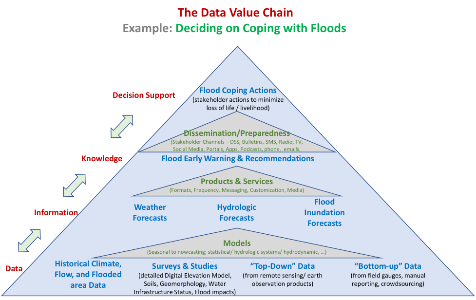
Decision Support
Decision Support Systems (DSS) are more integrated approaches to support water resources planning (e.g., watershed investment planning) or real-time systems operations (e.g., cascade of dams, flood management). It is critical to note that these are not decision-making systems but provide information to support decision making where the appropriate stakeholders bring in the value judgements of the synergies and trade-offs involved with various alternative decision paths.
It is useful to explore these from the viewpoint of a data value chain, to go from data to information to knowledge to decision support. It is best to start in reverse order, first outlining the decisions to be supported and then determining the ecosystem of data, analytics, and institutional arrangements required to support that decision.
Integrated Interoperable Frameworks
There is a need to ensure integration of the various parts of data and analytics for users to access, visualize, and interact with the information to support decisions. This requires a great degree of inter-operability amongst these systems. This has implications not only on the kinds of monitoring systems procured (to avoid vendor capture on hardware that is not interoperable with other information), but also to ensure that all the relevant data can be visualized and analyzed using interoperable dashboards or other platforms. The emerging world of online services, especially cloud storage and services are critical in this regard to tie it all together.