This section describes landscapes, the landscape approach, and global good practice in implementing the landscape approach. The next section of this e-book then delves into how this approach has been and could be applied in the Sahel region.
What is the Landscape Approach?
First, let us define what a landscape is. The World Bank defines a landscape as a socioecological system with spatial and geographic boundaries and functions and includes topography, natural resources, biodiversity, and various land uses. It is influenced by climate and culture as well as human activity. The boundaries of a landscape can be defined by a watershed, an administrative unit of government, an ecological area, a land feature, or any combination of these.
As such, landscapes are useful spatial units through which to manage multiple social, economic, and environmental challenges. The World Bank defines a landscape approach as “managing multiple land uses in an integrated manner, considering both the natural environment and the human systems that depend on it.” In this context, integrated landscape management means the development, prioritization and implementation of balanced solutions that consider social, economic, and environmental challenges and goals. This is a collaborative rather than a sectoral approach that aligns interventions, where for example agricultural production would be considered together with addressing social, economic and environmental processes that degrade soil. The benefits of using a landscape approach s are significant and meaningful. A useful resource to understanding the landscape approach is the World Bank Open Learning Center’s course on Landscape Approach 101 self-paced course.
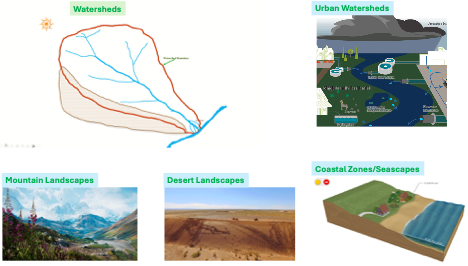
Illustrative Types of Landscapes
Current challenges with landscapes are related primarily to aspects of working across traditional silos (e.g. regions, sectors, institutions, disciplines) and to move to impact at greater scale, evolving new advancements and evolving good practices in technology, financing, partnerships.
Landscape management challenges can be addressed with a combination of the 3Is– Information, Institutions and Investments and an effort to integrate these approaches.
- Information:One of the major approaches in better managing landscapes is to improve the data, information, and knowledge base to better inform decisions related to planning and operations. Landscapes can be better managed through use of Monitoring Systems (in-situ, earth observation, crowdsourcing), Analytics (basin, precipitation-sheds, land use planning) and making associated data and knowledge publicly accessible.
- Institutions:The multi-sectoral nature of landscape management requires effective institutional frameworks to be in place among public agencies and local communities, with clear arrangements for integration across often fragmented local and higher level agency mandates, and for interagency collaboration (not only across administration levels but also across government, academia, private sector, CSOs, and communities). Therefore, the institutional framework for landscape management can be complex and very often faces several challenges to success, depending on the institutional conditions of every landscape.
- Investments: The needs for investments in landscape management are multiple and respond to a variety of objectives. There are two main types of investments: those in monitoring systems, for generating informationabout the status of various variables on the landscape; and on infrastructurefor sustainably managing the landscape. For investments to be efficient, sustainable and appropriate there are a number of commonly occurring challenges that require overcoming.
Information
One of the major approaches in better managing landscapes is to improve the data, information, and knowledge base to better inform decisions related to planning and operations. Decisions can only be as good as the data and analytic systems decisions are made with. Data that is comprehensive and accessible, coupled with analytic systems that can make effective use of the data to aid decision-making, is critical to effective landscape planning, especially in sensitive areas such as the Sahel. Data to aid in landscape planning includes data on land use and land cover, climate, hydrology, physiography, and a plethora of other social, economic, and environmental datasets. Fortunately, new data sets and tools are available, leveraging advances in satellites, cloud computing systems, artificial intelligence, and other cutting-edge technologies
Satellite Data
Numerous satellites circle the globe, gathering high resolution climate and other environmental data (e.g., land use/forest cover) that can be leveraged for more efficient and accurate landscape planning. These satellites include the NASA Global Precipitation Mission for rainfall, MODIS, Sentinel-3 and others. Satellite data can be used in conjunction with and ground-truthed by in-situ sensors and processed through models (e.g., the IPCC suite of climate modeling outputs) to generate information useful for decision-making. This knowledge is increasingly being made available through online services that analyze data and serve them through online portals (e.g., the World Bank Climate Change Knowledge Portal ) or generated dynamically in real-time with online/cloud services (e.g. Google Earth Engine, see below).
Other examples of satellite operations and data useful for landscape planning include new systems like GEDI, a LiDAR system on the International Space Station that provides data on forest canopy height.
Cloud Analytics
Cloud analytics apply algorithms to large datasets to generate knowledge about a particular topic. Cloud analytics allow for large storage spaces to house the massive datasets generated by satellite and sensor technologies used to gather data on variables relevant to landscape-scale management of environmental and other resources. The technology increases data integration and accessibility, and provides a platform for collaborative landscape management initiatives.
Google Earth Engine (GEE)is a cloud-based online analytics platform that provides access to multiple repositories of satellite imagery and geospatial datasets and allows for quick and accurate analysis and visualization of large datasets available in the cloud. The datasets include free geospatial data, optical and radar satellite imagery, climate information, digital elevation models, land cover maps and a variety of socio-economic variables that are relevant to landscape management approaches.
Artificial Intelligence (AI)
Advanced analytical tools such as AI and machine learning allow for the compilation and analysis of the massive datasets that are generated by satellites and other rapidly advancing data gathering technologies. Another example of AI useful for landscape management, in the form of predictive machine learning, comes from iSDAsoil, a collaborative effort to leverage data from different organizations that produced the first field-level soil map of Africa including over 20 soil properties. Importantly, the product offers a free API for developers, making the data more accessible and transparent for use in decision-making.
Access: Making data and analytics more accessible in the public domain could help in better understanding existing landscape conditions. These data are crucial for identifying, prioritizing, and restoring degraded areas, as well as for protecting healthy landscapes from emerging problems. There is also a strong need to support the development of online data using agreed protocols and formats and creation of free, online public-data services that can be accessed through open services and APIs to support further analytics and visualization. The availability of data in the public domain is challenging - especially in transboundary landscapes and watersheds - but a range of “disruptive” technologies are helping provide new avenues in this regard.
Institutions & Policy
Management of environmental and other resources at a landscape scale requires multi-sectoral coordination and communication in decision-making across different public agencies, communities, and potentially various entities in the nonprofit and private sectors. Institutional work can happen at the global, regional, national, and local levels. Multi-sectoral decision-making across institutions needs to be supported by viable institutional frameworks that help specify roles and responsibilities in landscape management activities, how information might be coordinated across agencies at different administrative levels and with different mandates, and how capacity building might be increased.
Global:Various global organizations such as WOCAT, GEO, NASA, UNCCD can help the region in improving the knowledge base for sustainable land management, land degradation monitoring and combatting desertification, respectively. Global partnerships such as CGIAR can help in sustainably manage natural resources and in increasing food security through its research-based policy solutions. Its water research institute IWMI helps provide water solutions for sustainable, climate-resilient development whereas IFPRI provides solutions to sustainably reduce poverty and end hunger and malnutrition in developing countries.
Local: At local stakeholder level, capacity building is a significant constraint. This can be solved through improved automation, innovative technologies and better local coordination, and consensus-building. Exchange of available data on landscapes is important between the countries in the region which usually is kept hidden due to archaic policies and mindsets. Accelerating technological progress has provided better, faster, and cheaper data and analytic services, paving the way for whole new world of opportunities for stakeholder countries to benefit from open data access.
Leverging Technology. Technology is also an important aspect of capacity building: technology internships and webinars, and e-learning opportunities can be leveraged to reach a broader audience of academics, government officials, and practitioners involved in sector work that contributes to the landscape approach across the region. For example, the MakerSpace Foundation is working with UNDP in South Africa to recruit and train individuals in digital skills and entrepreneurship.
Investments
Preparation of a robust investment pipeline across a landscape requires attention to technical, environmental, social, economic, and institutional aspects in order to facilitate implementation. In this space, adequate technical assistance and M&E play key roles.
Overall, there is a need for multi-faceted, multi-sectoral, and multi-level investments to address existing and evolving challenges and benefit from the opportunities available through landscape-scale management.
These investments can include:
- Institutional Infrastructure (for monitoring, institutional strengthening)
- Landscape Investments (nature-based and structural) related to soil and water management, sustainable productivity improvement and climate resilience
- Community Livelihood Improvement (e.g. climate-smart and eco-friendly agriculture)
- Services (e.g. for data, capacity-building, harvest/storage/transport/marketing of sustainable produce)
Good practices of linking upstream and downstream impacts and designing investments accordingly are found in the World Bank...include from Sahel portfolio
Nature-Based Solutionsare gaining acceptance globally as an investment paradigm that combines traditional grey infrastructure with more green options. A recent World Bank report underscores that nature-based solutions are gaining traction in sub-Saharan Africa specifically, where between 2012 and 2023 there were 300 new nature-based resilience projects representing $21 billion in funding.
Nature-Based Solutionsare gaining acceptance globally as an investment paradigm that combines traditional grey infrastructure with more green options.A recent World Bank report underscores that nature-based solutions are gaining traction in sub-Saharan Africa specifically, where between 2012 and 2023 there were 300 new nature-based resilience projects representing $21 billion in funding.
Nature-based solutions seek to preserve the ecosystem services nature provides by protecting and restoring natural systems. Well-functioning ecosystems provide a host of critical ecosystem services that support the natural world and human society. These services include provisioning, regulating, supporting, and cultural services. According to the IUCN , nature-based solutions are “actions to protect, sustainably manage, and restore natural or modified ecosystems that address societal challenges effectively and adaptively, simultaneously providing human well-being and biodiversity benefits.”Vegetation and soils, including forests, provide critical provisioning and regulating ecosystem services. Vegetation, including forests and trees, hold soil together, reducing erosion and retaining soil fertility (regulating service) while also purifying water (provisioning service). Vegetation and soils also absorb and hold water, moderating streamflow and reducing inland flooding, coastal erosion, and sea-level rise (regulating service).
NBS can be implemented at various scales and for multiple sectors. NBS can be implemented at the landscape level, where whole watersheds or ecosystems are managed, protected, and/or restored to positively impact ecosystem services that deliver benefits to agricultural areas, hydropower facilities, waterways, cities, and coastal areas. At the other end of the spectrum, NBS can be implemented at the local level, either as green infrastructure for stormwater mitigation in an urban area, or green infrastructure installed above a road in hilly terrain to prevent landslides originating from higher elevations. Appropriate NBS mitigation measures may be scale dependent. To understand priority areas for NBS investment, development teams should conduct landscape-level assessment to identify areas external to the immediate project site that may significantly impact the project through landscape-scale natural processes (e.g., erosion and sedimentation). For example, on a single hillslope, NBS may not be effective in isolation, but could be implemented at the hillslope with other risk reduction measures, as well as in the surrounding areas that impact the hillslope.
The Bank has explored the use of NBS in a variety of sectors, including for flood and coastal erosion risk mitigation. The Bank’s Nature-Based Solutions Program , started in 2017, seeks to collate information on NBS used in Bank projects, provide guidance on integrating NBS into future projects, and to mainstream the use of NBS in future projects in DRM and water management. The program has thus far focused on coastal flooding and erosion, river flooding, and urban stormwater flooding. A growing number of Bank projects incorporate nature-based solutions for disaster risk reduction, such as forest-based landslide risk management in Sri Lanka, coastal flooding and erosion in Vietnam , and urban and river flooding in Senegal . A synopsis of the Bank’s NBS program is available here .
As described above, Payments for ecosystem services is a growing field that provides income streams to support environmental protection and restoration for multiple direct and indirect co-benefits. Public-private partnerships (PPP) in this realm offer opportunities to align interests of communities, government, and private companies around environmental restoration. A recent World Bank project supported a PPP in Ethiopia to improve livelihoods and environmental health through an engagement on watershed development.
An example of the components of an integrated – or sustainable – landscape approach is provided below, from the World Bank’s Sustainable Landscape Management Program (SLMP) activities in Indonesia. As shown, multiple pillars comprise the SLMP that address aspects of land administration and governance, improved forest management, social and economic equity and growth, funding, and stakeholder engagement.
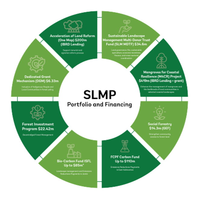
Components - SLMP
The video below provides information on the Bank’s Integrated Landscape Management Portfolio in Mozambique, a portfolio of projects that address a range of sectoral challenges and opportunities, such as blue carbon, forest and land degradation, agriculture, and biodiversity under a landscape management umbrella.
Case Studies of Integrated Landscape Management
Examples of the types of investments into innovative technologies that are effectively supporting landscape management in different regions globally are provided below. These are examples of global good practice in how integrated landscape management can be conducted.
The Loess Plateau is a 640,000 square km watershed located in northwest China with a population of fifty million people. Soil called loess is highly prone to wind and water erosion. Windstorms have transported material as far as Beijing, which is approximately 500 km away. Severe rainfall regularly washes away topsoil, causing deep gullies to form. Historically, for thousands of years, farmers have removed trees to grow crops and allowed sheep and goats to graze the area until the area is bare of any vegetation. Through these actions, four billion tons of sediments were conveyed into the Yellow River annually. The Chinese government had also been involved with terracing, building dams, reforestation, and providing goats and sheep to improve livelihood with detrimental effects on the environment. A lack of vegetation also caused farmers to seek higher elevations with steeper slopes for their livestock to graze on and leave the ground bare.
Through a World Bank project, larger terraces were constructed that doubled the crop yield and withstood the effects of erosion after a storm event. Annual grain yields increased by 60 percent. Farmers received long-term leases that ensured they would take care of the land without worrying their land would be taken away. Economic trees were provided by the project with the farmer providing the associated labor. A signed use and maintenance agreement was enforced once the trees were established. Livestock grazing was replaced with penned livestock. New breeds were introduced that produced higher quality milk and wool without the concern of disease. Income tripled over that time. By 2005, grazing was banned in the Loess Plateau region.
At the end of the project in 2005, three million people had benefitted from the project. Soil erosion was reduced on 920,000 hectares of land, and soil losses reduced by 60 million tons per year. By 2008, 240,000 square km of land had been restored. The successful approach introduced in Loess Plateau has since been applied to the Yangtze and Pearl River Basins.
This World Bank and GEF financed program sought to improve the framework for land and water management for ecosystem and livelihood benefits in targeted areas of the Shire basin. The project successfully developed scalable systems and methods to rehabilitate catchments and protect existing natural forests, wetlands and biodiversity in the Shire River Basin. National catchment management guidelines were developed and adopted at the national level and are currently used by various stakeholders. Various plans at the catchment level were developed to guide implementation of community-based land and water management interventions in four priority catchments of upper Lisungwi, upper Wamkulumadzi, Kapichira and Chingale, covering a total area of 129,000 ha (about 5 percent of the basin land area).
Consistent with global best practice on watershed management, the project adopted a livelihoods approach to catchment management by integrating livelihood-enhancing activities - i.e. establishment of 80 farmer field schools, provision of enterprise micro-loans for alternative (non-farm) livelihoods, community environmental conservation grants, and rural infrastructure for market access (80km of feeder roads, 11 bridges and 13 market centers). Beneficiary data obtained from the project M&E database suggest that 446,650 people (compared to a project target of 400,000) directly benefited from the project’s improved land and ecological management, as well as various livelihood enhancing activities linked to these interventions. About 50 percent of the beneficiaries were women. Overall, there is evidence that the livelihoods approach helped to increase farmers' adoption of sustainable land and water management practices. At project close, about 77 percent of households within the targeted catchments were reported to be engaged in sustainable land and water management practices, compared to a baseline of 15 percent.
An example of an integrated landscape approach in India is the Karnataka Watershed Development Project I through which inter-agency, district-level technical teams (under the leadership of the Watershed Department) were successfully engaged to provide coordinated support to communities during micro-watershed planning. This model was replicated in subsequent watershed management programs in the state, financed by the Indian Government. The state of Karnataka also pioneers a holistic approach to Watershed Development through its project Sujalato increase availability of water in seven drought-prone districts of northern Karnataka.
Land degradation is a severe problem in Ethiopia, especially in the northern highlands. Erosion occurs from overgrazing, steep topography, unsustainable agricultural practices, deforestation, and overpopulation. Through two projects focused on sustainable land management, the World Bank sought to address and reduce land degradation and increase land productivity in selected watersheds. Similar to other projects focused on a landscape approach, these projects supported interventions in multiple areas, such as improved land and water management practices, community engagement, property rights, and economic opportunities. The projects resulted in increased land tenure security, jobs, improved agricultural yields, and climate mitigation.