Technology
One of the major changes in traditional approaches to managing landscapes is to leverage a growing range of “disruptive” technologies. These include improved digital technologies that generate data, information, and knowledge to better inform decisions related to planning and operations, and physical technologies that improve upon status quo methods for things like crops and cultivation processes. This section covers both digitial and physical technologies for improved integrated landscape management. The statistics below underscore the power of technology in supporting integrated landscape management.
-
Sentinel-2 satellites can revisit the same location every five days, enabling frequent monitoring of forests, agriculture and land-use change.
Source: ESA -
FAO's Hand-in-Hand Geospatial Platform provides access to more than 2 million data layers for agriculture, natural resources and development planning.
Source: FAO -
Early-warning systems can provide more than a tenfold return on investment, while 24 hours' notice can reduce disaster damage by 30%.
Source: WMO -
Half-moon water-harvesting structures in Mali have increased soil moisture by up to 30% and crop yields by 60–100%.
Source: AGRA -
Farmer-managed natural regeneration has restored about 5 million hectares in Niger, showing how low-cost farmer-led techniques can work at landscape scale.
Source: CIFOR-ICRAF
Technology - Digital
Decisions can only be as good as the data and analytic systems decisions are made with. Data that is comprehensive and accessible, coupled with analytic systems that can make effective use of the data to aid decision-making, is critical to effective landscape planning, especially in sensitive areas such as the Sahel. Data to aid in landscape planning includes data on land use and land cover, climate, hydrology, physiography, and a plethora of other social, economic, and environmental datasets. Fortunately, new data sets and tools are available, leveraging advances in satellites, cloud computing systems, artificial intelligence, and other cutting-edge technologies.
Modern technology can not only help re-imagine landscape planning and management (including managing protected areas, reducing erosion, improving sustainable productivity), but also create a range of opportunities for livelihoods and jobs.
Satellite Data
Numerous satellites circle the globe, gathering high resolution climate and other environmental data (e.g., land use/forest cover) that can be leveraged for more efficient and accurate landscape planning. These satellites include the NASA Global Precipitation Mission for rainfall, MODIS, Sentinel-3, and others. Satellite data can be used in conjunction with and ground-truthed by in-situ sensors and processed through models (e.g., the IPCC suite of climate modeling outputs) to generate information useful for decision-making. This knowledge is increasingly being made available through online services that analyze data and serve them through online portals (e.g., the World Bank Climate Change Knowledge Portal ) or generated dynamically in real-time with online/cloud services (e.g. Google Earth Engine, see below).
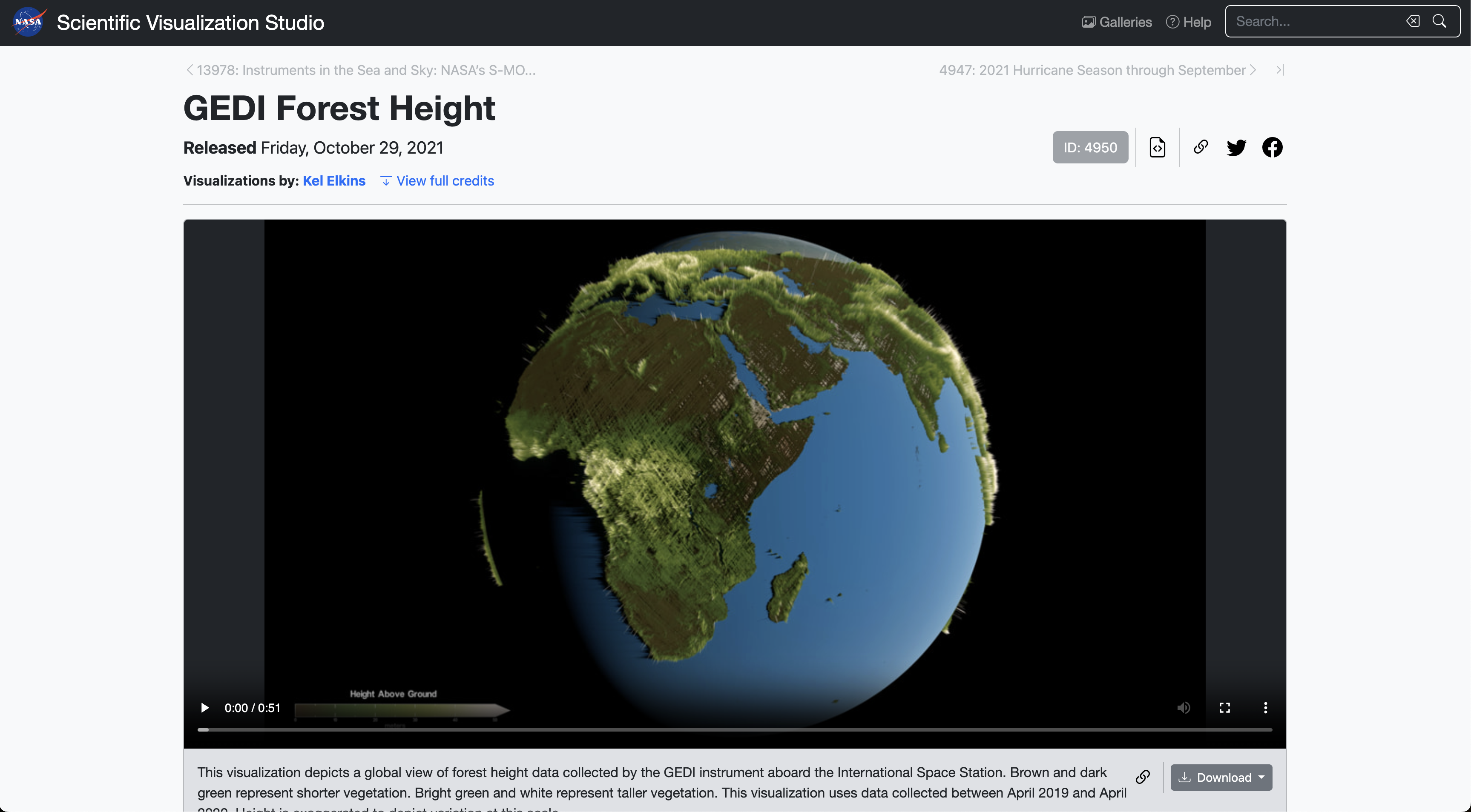
Other examples of satellite operations and data useful for landscape planning include new systems like GEDI, a LiDAR system on the International Space Station that provides data on forest canopy height.
Cloud Analytics
Cloud analytics apply algorithms to large datasets to generate knowledge about a particular topic. Cloud analytics allow for large storage spaces to house the massive datasets generated by satellite and sensor technologies used to gather data on variables relevant to landscape-scale management of environmental and other resources. The technology increases data integration and accessibility and provides a platform for collaborative landscape management initiatives.
Google Earth Engine (GEE)is a cloud-based online analytics platform that provides access to multiple repositories of satellite imagery and geospatial datasets and allows for quick and accurate analysis and visualization of large datasets available in the cloud. The datasets include free geospatial data, optical and radar satellite imagery, climate information, digital elevation models, land cover maps, and a variety of socio-economic variables that are relevant to landscape management approaches.
Artificial Intelligence (AI)
Advanced analytical tools such as AI and machine learning allow for the compilation and analysis of the massive datasets that are generated by satellites and other rapidly advancing data gathering technologies. Machine learning was recently used to develop a global prioritization of restoration sites:
Another example of AI useful for landscape management, in the form of predictive machine learning, comes from iSDAsoil, a collaborative effort to leverage data from different organizations that produced the first field-level soil map of Africa including over 20 soil properties. Importantly, the product offers a free API for developers, making the data more accessible and transparent for use in decision-making.
Access: Making data and analytics more accessible in the public domain could help in better understanding existing landscape conditions. These data are crucial for identifying, prioritizing, and restoring degraded areas, as well as for protecting healthy landscapes from emerging problems. There is also a strong need to support the development of online data using agreed protocols and formats and creation of free, online public-data services that can be accessed through open services and APIs to support further analytics and visualization. The availability of data in the public domain is challenging - especially in transboundary landscapes and watersheds - but a range of “disruptive” technologies are helping provide new avenues in this regard.
Explore an interesting “expert system” approach to zoom in and explore potential investment options in the Sahel.
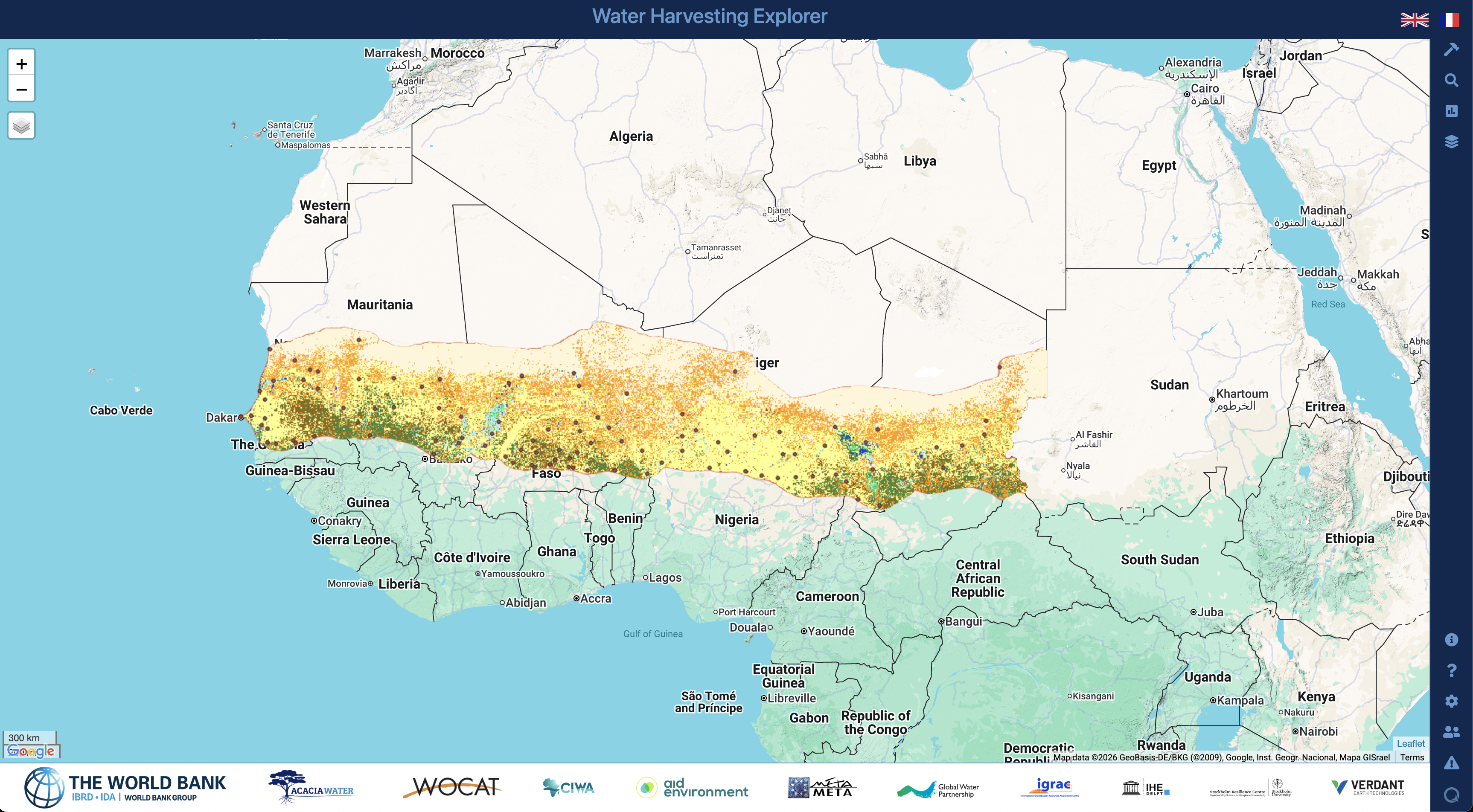
Various global organizations such as WOCAT, GEO, NASA, UNCCD can help the region in improving the knowledge base for sustainable land management, land degradation monitoring and combatting desertification, respectively. Global partnerships such as CGIAR can help sustainably manage natural resources and increase food security through its research-based policy solutions. Its water research institute IWMI helps provide water solutions for sustainable, climate-resilient development whereas IFPRI provides solutions to sustainably reduce poverty and end hunger and malnutrition in developing countries.
At the local stakeholder level, capacity building is a significant constraint. This can be solved through improved automation, innovative technologies and better local coordination, and consensus-building. Exchange of available data on landscapes is important between the countries in the region which usually is kept hidden due to archaic policies and mindsets. Accelerating technological progress has provided better, faster, and cheaper data and analytic services, paving the way for a whole new world of opportunities for stakeholder countries to benefit from open data access.
Technology - Physical
Physical technologies can bring improvements to landscape management to actions on the ground. Physical technologies include solutions such as live-check dams, 3D printed coral reefs, blue-green infrastructure, GPS-guided agricultural machinery, seeds/crops that are modified to be more drought-resistant. Physical solutions are available for different landscape types.
Live-check dams are small dams that store sediment in gullies with steep slopes. These dams are buildable using different materials and can slow down the flow of sediment and debris to downstream areas. The video below provides more information on live check dams.
The half-moon (demi-lune) is a micro-catchment technique where crescent-shaped holes are dug against slopes to form small dikes that retain water. The moisture-filled basins are sown with mixed cropping for root density and soil stabilization. Spacing between half-moons allows surplus water to flow to other half-moons. In Mali, half-moon structures retained 30 percent more soil moisture during dry spells, with yields increasing 60 to 100 percent compared to untreated fields. The Masai community in Kenya, is using the half-moon to restore 3,000 hectares of degraded land as shown in the video below.
The zai pit system increases soil fertility through digging pits 20 to 40 cm wide and 10 to 15 cm deep that are filled with compost or manure to provide plant nutrients. Termites attracted by the organic matter create tunnels that further break down the soil and improve infiltration. Millet and sorghum yields using zai pits can reach 1,500 kg/ha compared to less than 500 kg/ha under normal conditions. Senegalese farmers have been using the zai method since 2017 to improve crop resilience as the rainfall season has shortened, as shown in the video below.
Farmer managed natural regeneration (FMNR) is practiced in at least 24 countries and involves pruning and managing trees that regrow from existing stumps and root systems in farmland. Farmers remove unwanted stems and side branches while keeping sunlight and space for crops. In Niger, the practice helped regenerate over 200 million trees across 5 million hectares over 20 years, at a labor cost of around $14 per hectare compared to $18,000 per hectare for conventional tree planting. Farmers in Ghana are using FMNR to reverse declining crop yield and restore tree cover on degraded farmland as shown in the video below.