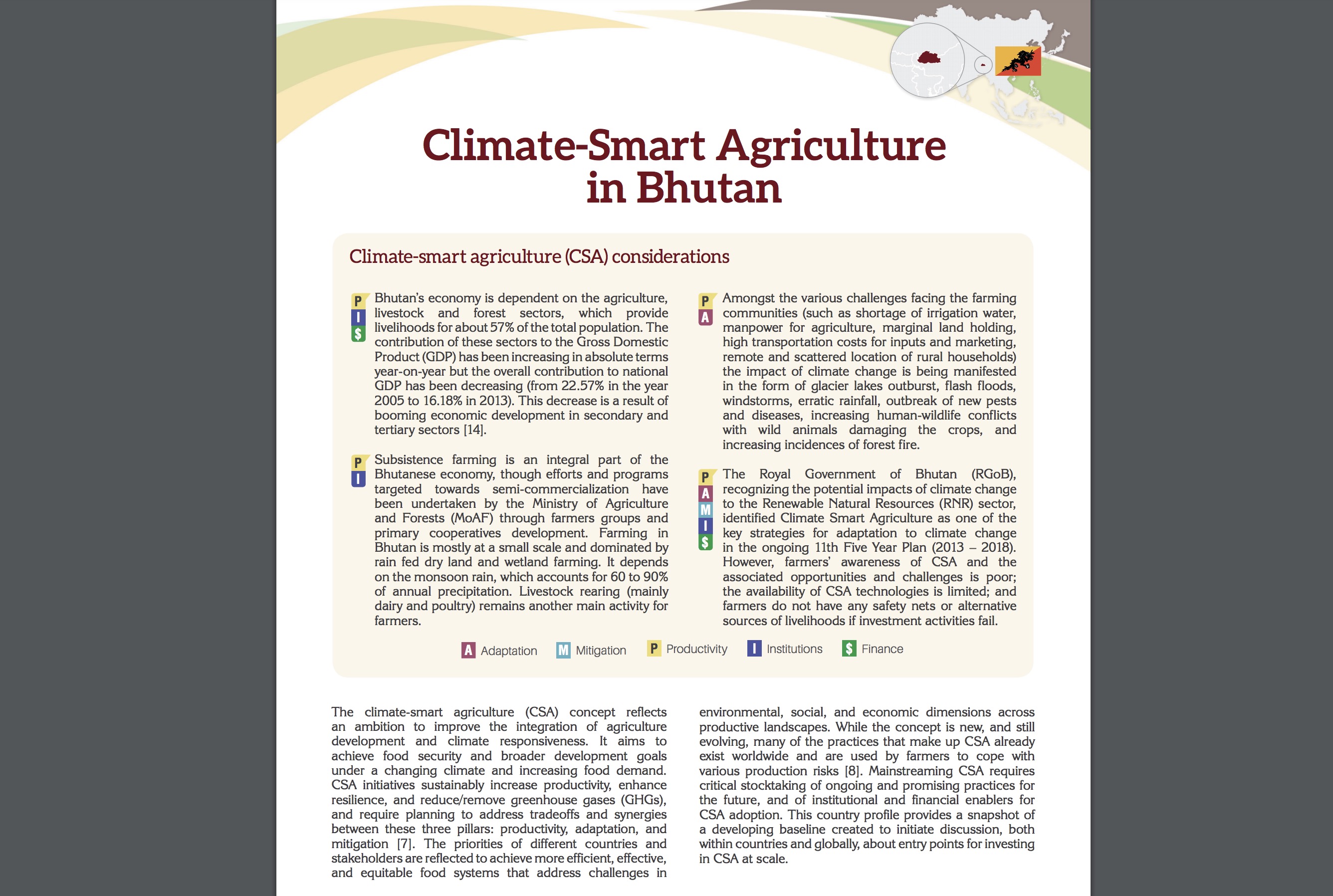
Economic
GDP
Bhutan is a lower middle-income country. Average annual growth of Gross Domestic Product (GDP) has been 7.5 percent since the early 1980s, making Bhutan one of the fastest growing economies in the world. Gross National Income (GNI) per capita, at $3,080 in 2018, is now three times the threshold for lower middle-income countries and only 10 percent below the threshold for upper-middle income countries. Poverty measured using the $3.20 poverty line (in 2011 PPP terms) has declined from 36 percent in 2007 to 12 percent in 2017.
Bhutan’s economy is driven by tourism, hydropower, and agriculture. Agriculture employs 60 percent of the population and accounts for the 17.4 percent of the GDP in 2017. Cash crops such as rice, potatoes, chilies, apples, maize, and oranges are highly susceptible to temperature and precipitation changes. Hydropower produced 1606 MW of electricity in 2018. Lastly, Bhutan is a popular tourist destination due to the pristine quality of its natural and cultural treasures. Tourism accounts for more than 9% of the country's GDP. In 2019, water-related activities contributed over 35 percent of GDP from the National Accounts Report, where major relevant subsectors are shown in this chart.
Trade
Bhutan is ranked as 177th on the list of exporters in the world with its exports increasing from $168M in 2014 to $250M in 2019. Exports include Ferroalloys, Dolomite, Semi-Finished Iron, Cement, and Carbides. The most common destination for the exports of Bhutan are India, Italy, Turkey, Germany, and Singapore.
In 2019 Bhutan imported $819M, making it the number 185 trade destination in the world. Bhutan’s imports increased from $240M in 2014 to $819M in 2019 with major imports including Refined Petroleum, Iron Reductions, Delivery Trucks, Cars, and Wood Charcoal. The most common import partners for Bhutan are India, Thailand, France, United Arab Emirates, and China.
Social
Demograph
Bhutan's population is very heterogeneous, with the highest concentrations located in the capital Thimphu. Approximately 60% of Bhutan's population lives in rural areas, with a population density of 19 people/KM2. As farming on steep slopes is incredibly challenging, educated young people are choosing to migrate to urban areas searching for work, which has caused a decline in the agricultural workforce, as shown in the nearby chart.
The total population is expected to rise by 28% to 44.5 million by 2050. Bhutan's overall population age distribution is relatively young, with the majority of people under 35 years of age. There are slightly more young males than females from the 20-29 age bracket.
Bhutan’s overall population is growing where the annual growth rate is declining.
Poverty
Poverty levels in Bhutan are high are low compared to South Asia. The chart below shows the poverty headcount ratio at $1.90 a day (2011 PPP) (% of population) in Bhutan from 2003 to 2017. Data is based on primary household survey data obtained from government statistical agencies and World Bank country departments.
Access to Basic Services
In recent years, Bhutan has made great strides in reducing poverty and enabling more equitable access to basic services. Bhutan’s Multidimensional Poverty Index shows divergence of access to basic infrastructure between urban and rural areas. Bhutan’s access to electricity (% of population) stands at 100 percent as per the World Bank 2019 data, whereas access to safely managed drinking water remains at 36 percent.
According to a World Bank document on Regional Development and Economic Transformation, for rural and remote regions and regions with low endowments, higher levels of poverty and infrastructure gaps, efforts should focus on equitable access to basic public services, especially health and education services, that will improve human capital outcomes, enhance the quality of the labor force, and provide skills that residents can use to move to larger centers.
Environmental
Forests & Ecosystems
Bhutan is required by law to maintain at least 60 percent forest cover. As of 2010, 65% of Bhutan was natural forest cover with 2.51Mha of natural forest, 31ha of plantations and 1.37Mha of non-forest area. According to Hansen data, Bhutan lost 10.3kha of tree cover, equivalent to a 0.40% decrease in tree cover from 2001 to 2010, and 4.89Mt of CO₂ emissions. In 2020 alone, the country lost 1.29kha of tree cover, equivalent to 540kt of CO₂ of emissions.
Forest loss occurs from a variety of factors that include forest fires, deforestation, and agriculture where the major drivers affecting forest loss from 2001-2019 are shown in the nearby chart.
<
There is a heavy requirement to use firewood for cooking at schools, institutions, armed forces, road construction, and residential housewarming with the lack of power. The volume of firewood has increased by 14 percent from 2018-2019, as shown in the nearby chart.
Bhutan Biodiversity
Bhutan is considered a biodiversity hotspot since it has 5,603 flowering plant species under 220 families and 1,415 genera, almost 200 species of mammals, 800-900 species of butterfly, and 50 freshwater species. According to a herpetological survey from 1999, the country is home to 23 reptile and species of reptiles and amphibian species. Lastly, the country is considered to have avian community with 678 avian species. However, some species are endangered, as 1 mammal is critically endangered, 11 endangered, and 15 vulnerable.
The video explains why Bhutan’s is a biodiversity hotspot.
Water Quality
The main rivers and tributaries of Bhutan are believed to be very good. However, water quality is under threat from population expansion and growing urbanization. Soil erosion is exacerbated by deforestation and land degradation caused by livestock overgrazing. High sediment load is damaging to hydropower turbines. Water quality is currently being monitored, but the observations are neither systematic nor consistent.
To ensure the safety of public health and water quality for the people of Bhutan, the drinking water quality standards were established in 2011. The standards set the parameters and maximum allowable for drinking water in Bhutan.
Erosion
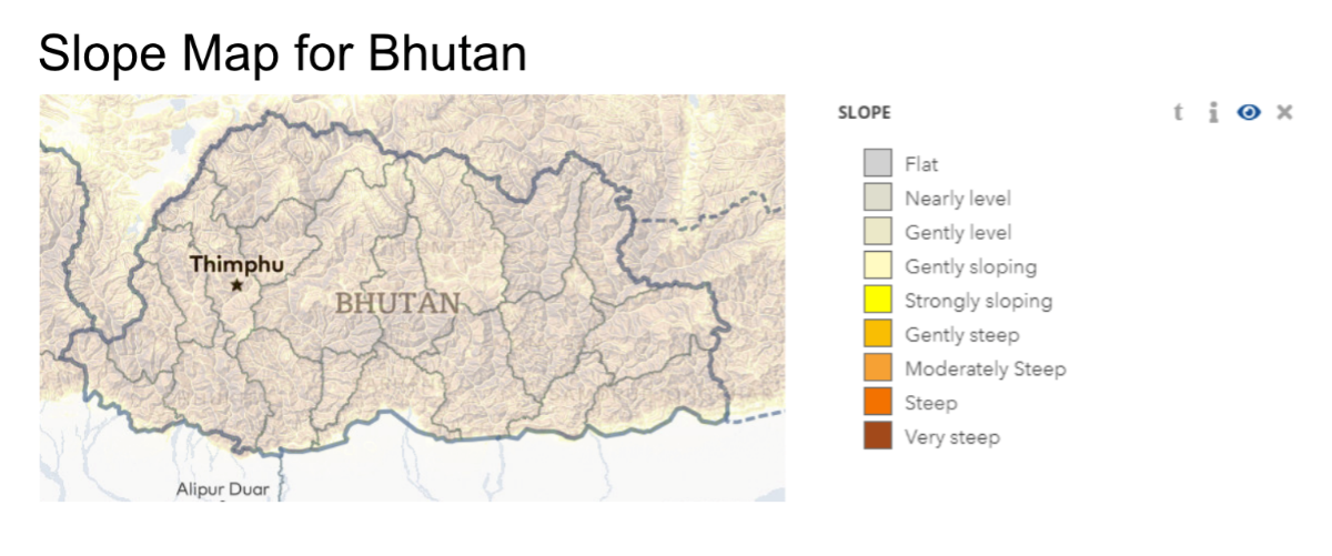
Bhutan’s arable land has limited resources, where three percent of the land is considered arable because of its topography and altitude. The country is naturally prone to elevated levels of erosion since the land is steep or very steep as shown in the nearby figure. This would place resources at particular risk from degradation posing a serious threat in most places.
There are limited pasture rangelands, so cattle graze forested areas. Forest regeneration is hampered by the frequent eating and uprooting of saplings along with trampling of the soils. The same lands are grazed twice a year, once by yaks and once by cattle.
The impact of increased sedimentation is damage to turbines on hydropower plants and frequently clogs intake pipes of water supply systems.
Climate
Bhutan exhibits spatial and temporal heterogeneity in its climate. Bhutan's temperature and precipitation are affected by variations in altitude, geography, location at the edge of the tropical circulation in the north, and the border of the Asian monsoon circulation in the south . The country has three types of climates, which are subtropical, temperate, and alpine. Subtropical climate located in the southern region has an altitude from 200-2000 meters. Temperate, has an altitude of 2000-4000 meters, is in the central area. Lastly, the Alpine region altitude is over 4,000 meters and is located in the northern belt.
Basic Climate
Temperature
Bhutan's mean annual temperature is 11.9 °C with variation based on climatic zones. The subtropical temperature ranges from 15-30°C and can reach 35 °C during the summer in the valley. The temperate climate varies from 15-26 °C during the monsoon season and -4 °C to 15 °C during the winter season. Alpine temperatures are cool during the winter and summer months with some regions of the high Himalayas being below freezing all year.
Trend: There are high variations in the interannual temperature from the nearby figure; the overall trends from station data show a decreasing trend.
Temperature Change in Bhutan (Average Temperature Anomaly, 1901-2020
Precipitation
Long-term average annual precipitation in depth: 2,200 (mm/year) (2017)
The subtropical climate of the southern areas is commonly hot and humid during the monsoon and chilly during winter, with an annual precipitation ranging from 2500mm to more than 5000mm. The temperate zone of the middle mountains and valleys is cold in the winter, balmy in spring, hot in summer and mild in fall, with annual precipitation ranging between 1000mm and 2500mm. Finally, the alpine climate of the northern area is cold throughout the year. Annual precipitations in this area are limited to 500mm to 1000mm.
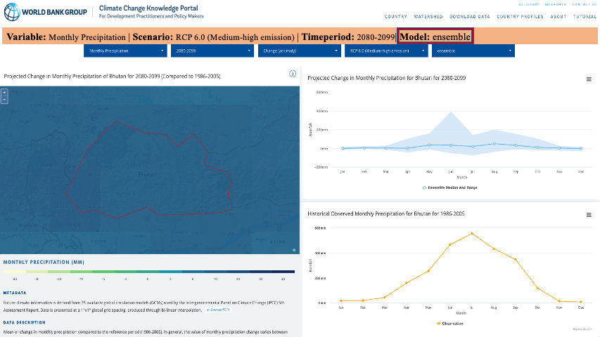
Bhutan’s Precipitation future projections (2080-2099) from Climate Change Knowledge Portal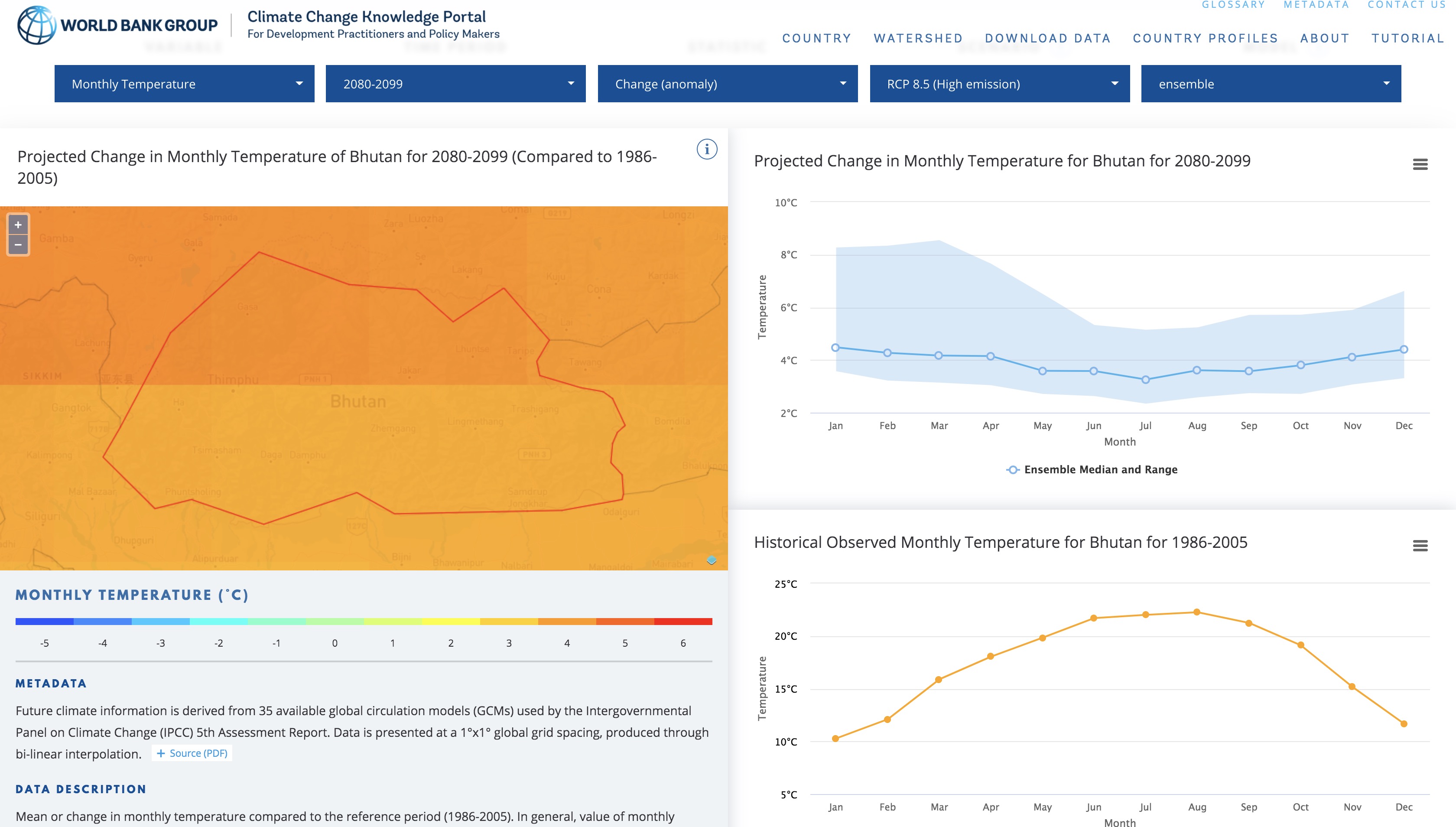
Trend: Precipitation has been declining overall with large variations in the interannual precipitation as shown in the nearby graph.
The hydromet monitoring stations in Bhutan can be interactively explored below:
Hydrometeorological Extremes
Bhutan has been experiencing frequent hydro-meteorological and geological disasters such as glacial lake outburst floods (GLOFs) , earthquakes, landslides, windstorms, forest fires and the like. Currently, climate-related impacts are evident in the melting of the glaciers and attention is being given to the risk of GLOF, which occurs with regularity in the valleys and in low lying river plains.
Monsoon brings torrential rains from June to September. Western Bhutan is particularly affected by monsoons which bring between 60% and 90% of the region's rainfall annually. Flash floods (see example of recent event ) are triggered by monsoon rains particularly in the southern Bhutan along the border with India where the terrains are intensively dissected with deeply eroded, steep and closely spaced gullies, gorges, and river valleys, combined with low permeability or saturated soils. Flash floods produce the most damage in urban areas. Landslides are also of annual occurrences in the southern and eastern foothills during the monsoon season due to steep slopes. Landslides also lead to the unstable formation of natural dams and lakes, which later burst as their structure fails.
Drought
Bhutan’s high water availability per capita masks spatial variation in water availability as Bhutan has one of the highest water per capita in the region at around 109,000 m3 per capita per year in 2017. Localized drought occurs with changing rainfall patterns, reduced snowfalls, and melting glaciers that will dry up the water sources. As Bhutan farmers are subsistence farmers, a failure monsoon storm or a delayed onset of rainfall will result in crop loss and associated livelihood damages. For example, crop production was significantly affected in 2012 when the southern districts experience no rain.
Drought exposures is more pronounced in the western Bhutan where the population is higher, but it also manifests across the country due to lack of seasonal storage for irrigation and other needs (see example ).
Floods
Floods are a serious concern in the Bhutan where the total number of events have increased since the 1990s. Floods have impacted loss of life, structures, agricultural lands and the the total number of people affected. The flood observatory maps shows flood locations from 2013. Flash flood events are now a common occurrence during the monsoon season, when in July 2016, the town called Sarpang, oldest commercial settlement, was wiped out within hours . There was extensive damage from 2000 and 2004 flood event from heavy rainfall since it damaged highways, agricultural lands irrigation channel and water supply. The estimated direct and indirect impact on GDP from floods is 0.36%.
Climate Change
The Intergovernmental Panel on Climate Change estimates that by 2100, South Asian countries, including Bhutan, will experience increase in average temperatures, with increases in daily minimum and maximum temperatures, mostly taking place at higher altitudes. A 5% decrease in precipitation is expected during the dry season, and an 11% increase during the wet season is expected in the long-term. Under a warmer and more variable climate, the onset of monsoons will be more erratic which will cause disruptions in natural and agricultural cycles – Bhutan is already experiencing an increase in the frequency of intense monsoon rains causing flash floods and landslides. The increase in temperatures also affects water quality, as it causes algae growth, which also poses challenges for wastewater treatment.
Explore Bhutan’s climate change scenarios at the World Bank Climate Change Knowledge Portal.
Coming to grips with water: How Bhutan is overcoming challenges magnified by climate change
Climate smart agriculture Bhutan