Looking Ahead
Bhutan water vision 2025
This Bhutan Water Vision 2025 is a multi-sectoral policy document at the national level for the period of 2014-2025. The Water Vision states that water is the most important natural, economic, and life-sustaining resource and it must be ensured that it is available in abundance to meet increasing demands. Present and future generations will have assured access to adequate, safe, and affordable water to maintain and enhance the quality of their lives and the integrity of natural ecosystems. To achieve the Vision water must be used and managed sustainably, efficiently, and equitably while preserving the environmental, social, cultural, and economic value and use of water. To this end, all water users, planners, and decision-makers shall be informed, educated, and encouraged to value and protect water in all its forms and uses.
The Water Vision is based on the principles of environmental conservation, integrated water resources management, sustainable use of water resources, economic efficiency, equity, and good governance.
The Water Vision proposed the goals and targets, including: The conservation of watersheds, monitoring water quality, impact of urbanization, public awareness on water resources issues; Increased agricultural productivity and production through improved water use efficiency; Tap hydropower vast potential for socio-economic development and self-reliance; Identify and license water bodies/courses for fish farming; Allocate adequate quantity of water in industries and comply with pollution standards; etc.
Recognizing urban and rural poverty as one of the drivers of change, the Water Vision seeks to achieve 100% coverage of safe water supply and sanitation in both rural and urban areas and reduction of water-related diseases.
The Water Vision further seeks to forecast and prevent disasters caused by water such as floods and landslides. One of the priorities is: Water for nature conservation, including prevention of natural disaster and emergencies shall always be a guiding element in all water allocation decisions.
Technological Disruption
The water sector faces increasing pressures especially due to the impact of climate change. In the developing world governments will have to increase resilience and sustainability within the sector, within water scarcity and safety, water efficiency, operations of utilities, the treatment and monitoring of water resources and the generation of data and analytics, technology will play a critical role. Globally, there is a growing willingness of to test and adopt some of these new technologies among utilities and operators; technologies such as remote sensing of water which can help with water accounting, non-revenue water remediation, artificial intelligence and big data also offer the capability now to analyze large volumes of water data to aid in decision support and policy making for the sector, in the area of water in agriculture , the internet of things is also enabling smart irrigation for efficient use of water.
These technologies also help utilities to move to serving customers digitally, enable remote and real time management of water resources, utilize distributed technology for the expansion of water and wastewater management services to communities ( World Bank ).
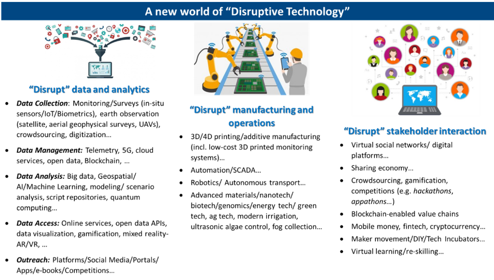
More information on this growing world of modern technologies here. There are many examples of how this new world is changing or expected to change a range of “sectors.” In fact, a key implication of these technologies is that they both require and enable us to think beyond the comfort zone of traditional “sectoral” boundaries.
Recommendations
Water security challenges can be better addressed with a combination of the 3Is – Information, Institutions and Investments.
A description of the Investment, Institutions, and Information is described further by clicking on the I’S icon. Clicking on the hand icon will revert to the homepage.
Interactive Figure: The Three I’s (Information, Institutions, and Investments)
Information
One of the major approaches in better IWRM is to improve the data, information, and knowledge base to better inform decisions related to planning and operations. Water resources can be better managed through use of Monitoring Systems (in-situ, earth observation, crowdsourcing), Analytics (basin, precipitation-sheds, land use planning) and making associated data and knowledge publicly accessible.
Monitoring Systems: It is often said that you cannot manage what you cannot measure. There is need to improve Bhutan’s monitoring of water resources and related investments to improve their longer-term planning as well as short-term management. This includes- In-Situ Observations: These can be done through improved in-situ observations using sensors or smartphone apps.
The Bhutan National Center for Hydrology and Meteorology (NCHM) mission is focused on monitoring and understanding of hydrology, weather, climate and cryosphere, for timely provision of information and services to protect lives and property and support national needs for ecologically balanced sustainable development. This has relevance in water resources management whereby the understanding of Bhutan’s water balance and possible impacts from climate variability will help the planning and use of the Bhutan’s precious water resources.
Technical solutions below focus on sustainability, whereby the cost of maintaining high-quality in-situ measurement is of most importance.
- Precipitation Measurement: Additional precipitation measurements are needed to help NCHM quantify rainfall, especially in measurement sparse areas such as those areas above 2,000 m. The additional precipitation sites can also be used to calibrate the weather radar that is also proposed. A uniform network (well-spaced) will allow a weather radar to improve quantitative precipitation estimates, which in turn is critical component in water supply and water balance. It is recommended that tipping bucket precipitation gauges be used at lower elevations (< 500 m) and fluid precipitation gauges, such as the OTT Pluvio, used at higher elevations, or where snow fall occurs. The precipitation network should be increased by 50 stations. These stations do not need to measure all weather parameters but can be precipitation only. Stations at high elevation where a significant snowpack is expected to accumulate should be equipped with a snow depth measuring device, such as an ultrasonic or laser snow depth sensor.
- Snow and Glacier Measurement : Mass balance of glaciers have shown a consistent decline of glacier mass in Bhutan. Additionally, the accurate measurement of snowfall and snow depth is needed to characterize the amount or runoff expected from runoff. There are several emerging in-situ Snow Water Content (SWE) instruments. The first is a mechanical snow pillow that is a significant improvement over liquid filled snow pillows. Another exciting advancement is the development of a Cosmic Ray Detector (CRD) to measure the number of cosmic rays reaching the detector. These tools are available from Alpine Hydromet and Campbell Scientific.
o Instrumentation to measure snow depth have typically employed ultrasonic sensors. Newer technical solutions to measure snow depth includes the use of laser technology. Lufft provides a laser snow depth solution.
o The use of airborne drones is having an impact in water resources monitoring and especially snow/glacier monitoring. Heavy lift drones are being tested with on-board lidars to measure elevations along its flight path. Though the cost of heavy lift drones can be quite expensive (upwards to $250,000 USD), acquiring a more modest, less expensive, high speed (~75 km hr-1) heavy lift drone with lidar would allow NCHM stay current with emerging technologies and provide a valuable tool for monitoring snow and glaciers at regular intervals quickly and safely.
o Lastly, the use of Ground Penetrating Radar (GPR) is gaining wider use in monitoring glacier thickness, though the use of the GPR requires transporting the unit on a sled across the glacier, which requires significant effort.
o It is suggested that remote frozen precipitation gauges and SWE sensor be equipped with either laser or ultrasonic snow dept sensors. A sufficient number of these should be acquired to equip all meteorological and snow stations.
o It is suggested that three mechanical snow pillows be acquired along with three CRD SWE sensors to better define the SWE and monitor the snow melt process. Otherwise, NCHM could just purchase 5 or 6 CRD devices and forgo the mechanical snow pillows.
o NCHM should consider their need for evaluating the heavy lift drone and GPR and purchase accordingly.
- Surface Water Measurement: Surface water measurement needs to focus on stream gauging instruments, such as the ADV and profiling ADCP. These instruments are vital in measuring the discharge in the rivers. In particular, the use of ADVs in shallow water would be helpful to round out the stream gauging tools available to NCHM. Additionally, a profiling ADCP with portable tagline could be used as at multiple locations where the channel width allows. Accessories, such as floating platforms, bridge cranes and other tools will allow NCHM to use the ADCPs at multiple locations.
- Ground Water Measurement: Ground water measurement requires increased monitoring, especially in the areas where there is ground water extraction. Ground water monitoring should be automated, which consists of the acquisition and placement of a submersible transducer that is coupled with a mobile network transmitter (GSM/GPRS). The use of this technology would be primarily the southern border of Bhutan, where ground water extraction is more prevalent. However, these sensors can be, and should be deployed in other areas to monitor baseline conditions of ground water.
- Water Quality Measurement: Water quality in rivers can be automated with Real-time Water Quality Monitoring, which includes a wide array of sensors to measure water quality, and a data collection system to record and relay the data in real-time to NCHM. Automatic measurements of Turbidity, Dissolved Oxygen, Electro Conductivity, pH, nitrates, COD, COD and others are available in automatic sensors. The need for collecting baseline data in forming a water quality profile should be a high priority for Bhutan.
- Data Collection Platform: NCHM has been involved in a study using low-cost data loggers in coordination with the WMO. The effort of using low-cost data loggers should be scaled up. This would permit NCHM to establish/replace data loggers and sensors as they need at little cost. In fact, the 3D-PAWS has already been developed for precisely this purpose. Therefore, it is recommended that NCHM acquire the 3D-PAWS technology, which includes a 3D printer, production diagrams and programs from the National Center of Atmospheric Research (NCAR-USA), and enough supplies for 100 stations. It is estimated that this would cost less than $30,000 USD, not including training and support from NCAR to get the production established for NCHM.
- Data Transmission: Data relay is of paramount importance in a real-time information system. Collecting data in real-time allows the agency to evaluate data quickly and eliminates the need to digitize data. The problem with many data relay methods is the cost of data relay. Fortunately, data relay is supported by many Global Observation System satellites, such as METEOSAT (Europe), FY (China), MTSAT (Japan), and INSAT (India). Generally, the cost to use these relay systems are free of charge. NCHM is already utilizing METEOSAT for the relay of hydromet data from the GLOF system. The use of these highly sustainable data relay platforms should be expanded. Coordination usually takes place with the respective national agency. For instance, request to use the FY Data Collection System (DCS) is coordinated with the China Meteorological Administration (CMA), and MTSAT with the Japan Meteorological Agency (JMA).
- Calibration Facilities: NCHM has been heavily involved in automating their hydromet network over the past 10 years. However, there is a need to calibrate these sensors, especially calibration of general state parameters, such as temperature, relative humidity, atmospheric pressure, rainfall and others is very important in order to assure that high quality data is being collected. This will require the purchase of test equipment and chambers, and other low-cost tools that will allow the simple, quick and accurate check of common sensors.
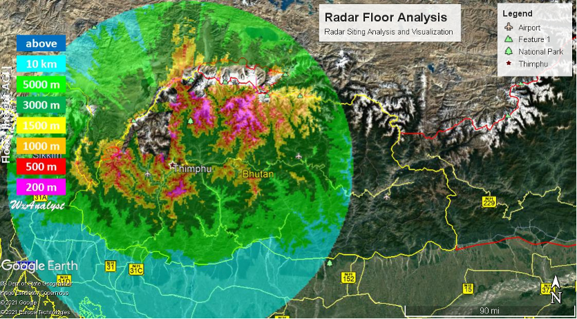
- Weather Radar: A weather radar is an asset which estimates precipitation intensities and wind information aloft over the range of the radar, which nominally reaches 150 km for the radar transmitter. The weather radar is also able to provide quantitative precipitation estimates from virtually any point within the radar coverage area. A weather radar, when operating continuously, and in conjunction with a precipitation network, can yield reliable data on volume of precipitation reaching the ground. NCHM does not currently operate a weather in Bhutan, but it is recommended that a weather radar be located near Thimphu, which will provide precipitation quantity and intensity in the Wang Chu basin and beyond. It is suggested that a C-Band radar be used, which will provide better definition of cloud structure while providing adequate coverage within 150 km of the radar, even in intense convection.
o A potential site for a weather radar has been determined to be at 27.49604 North Latitude and 89.69560 East Longitude. A floor analysis, which depicts the lowest height of the radar beam above the ground. Of course, the closer the beam is to the ground, the more reliable the estimates of precipitation.
- Hydromet Database Management: The WMO Meteorological, Climatological and Hydrological database management system, known as MCH, manages observational data from its three namesake areas – meteorology, climatology and hydrology – under a single platform. By doing so, MCH facilitates data exchange among National Meteorological and Hydrological Services (NMHSs) and the gathering, in a unique system, of all the data needed for cross-cutting analysis of climate, weather and water phenomena. MCH offers a solution for NMHSs that are looking for a simple, customizable and license-free solution to store, analyze and visualize data. The system permits them to manage and generate reports on large amount of observed data. NCHM has been evaluating database management solutions for their ever-increasing data streams. It is recommended that NCHM use the WMO supported MCH database software which meets the requirements of being low cast, in this case free, and well supported with an ever-increasing number of users taking advantage of the MCH database.
- Time Series Processing Software: Time series processing software is a tool for hydrological data that helps the use perform quality control, establish rating tables, and adjust water level and discharge as shifts occur to the rating table. There are several developers of this type of software, including Hydstra, Aquatic Informatics and Seveno. Seveno is the only manufacturer that does not require annual maintenance costs which makes this solution much more amenable to NCHM considering the high expense of the annual maintenance agreements of the other two solutions.
In addition, there are tremendous opportunities to improve the use of Earth Observation and other global data products as well as free or low-cost cloud analytics (e.g. use of APIs, online OGC-compliant services, and tools like Google Earth Engine) to develop a new generation of tools to better assess and manage climate/weather indicators, droughts/floods, and other aspects that can help operationalize information-based IWRM.
Analytics: These can be done with the support of a new generation of cloud computing (including free options) that could also be very useful in areas with limited connectivity. For example, novel approaches to improve streamflow forecasting for the entire basin- GEOGLOWS which provides streamflow forecasts 15 days in advance with uncertainty boundaries based on ECMWF (European Centre for Medium range Weather Forecasting) 51-model forecasts and historical streamflow estimation for the last 35 years.
Bhutan IWRM information system is a step in the right direction. Several types of information are being generated about the country’s water resources, including on hydrological and management basins. The information is available online in the form of an interactive WebGIS and various maps. Additionally, the system allows for public viewing of automated information on water security.
These aspects are further illustrated in the interactive Bhutan Water Resources Data & Analytics E-book that has been developed as a companion document to this e-book.
Institutions & Policy
While many countries are still trying to adapt the IWRM concept to their own country needs, Bhutan began embedding these principles in various sector legislations and mandates early and brought out a comprehensive National Integrated Water Resources Management Plan (NIWRMP) in 2016. The NIWRMP emphasizes coordination as the key management principle both at the central and the river basin level. The Bhutan Water Security Index (BWSI) is the core plank on which the coordination mechanism is designed among the water related agencies in the country. This index captures the status of water resources and their related services in five key dimensions, which are (i) rural drinking water supply, sanitation, and hygiene; (ii) economic water supply for agriculture, industries, and hydropower; (iii) urban water supply, sanitation, and drainage; (iv) environmental water security; and (v) disaster and climate change resilience. These have further 11 sub-dimensions and 57 indicators and together provide the framework for planning, monitoring, and inter-agency coordination (NIWRMP, 2016).
There are many opportunities to leverage modern technologies and processes to build the capacity of institutions to better plan and manage activities in an integrated watershed context.
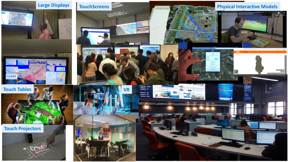
This includes modernizing institutional infrastructure to work effectively in the modern world and be able to better integrate technology into their business processes. This will include the need for appropriate equipment (e.g. computers, smartphones, displays and other tools, videoconferencing), furniture, and connectivity to enable people to work effectively to access, visualize, share, and discuss relevant groundwater data.
While many countries are still trying to adapt the IWRM concept to their own country needs, Bhutan began embedding these principles in various sector legislations and mandates early and brought out a comprehensive National Integrated Water Resources Management Plan (NIWRMP) in 2016. The NIWRMP emphasizes coordination as the key management principle both at the central and the river basin level. The Bhutan Water Security Index (BWSI) is the core plank on which the coordination mechanism is designed among the water related agencies in the country. This index captures the status of water resources and their related services in five key dimensions, which are (i) rural drinking water supply, sanitation, and hygiene; (ii) economic water supply for agriculture, industries, and hydropower; (iii) urban water supply, sanitation, and drainage; (iv) environmental water security; and (v) disaster and climate change resilience. These have further 11 sub-dimensions and 57 indicators and together provide the framework for planning, monitoring, and inter-agency coordination (NIWRMP, 2016).
There are many opportunities to leverage modern technologies and processes to build the capacity of institutions to better plan and manage activities in an integrated watershed context.
This includes modernizing institutional infrastructure to work effectively in the modern world and be able to better integrate technology into their business processes. This will include the need for appropriate equipment (e.g. computers, smartphones, displays and other tools, videoconferencing), furniture, and connectivity to enable people to work effectively to access, visualize, share, and discuss relevant groundwater data.
Leveraging the wisdom of the crowd, especially the youth, is a promising institutional approach globally. Across the world, various competitions including hackathons, data jams, blogathon, X-prize, design and other innovation challenges are being organized to develop solutions to the most pressing water sector problems of our times.
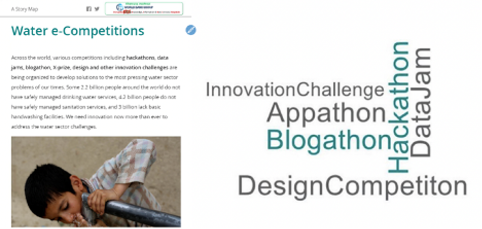
Hackathons are design sprint-like events, that often involves computer programmers and other software development techies, including graphic designers, interface designers, project managers, and others to collaborate intensively on developing software projects and applications. The goal of a hackathon is usually to create functioning software that focus on a specific challenge related to any topic. A group of experts, programmers, college students, or whoever wants to share their knowledge are invited to a workshop to harness their expertise and curiosity to design solutions for identified problems.
Hackathons are flourishing all around the world and have also been used on issues relating to Water (see World Bank Lessons from Water Hackathons ). They are a quick way of bringing innovation to an old-time problem. Solutions come from putting together individuals that bring-up a diverse set of quality ideas that could get years to reach without the proper forum to develop them. It is also very cost efficient since the traditional innovation models often require big investment and longer span of time to reach the solution, while hackathons can lay the first stone of an idea in a few days.
Hackathons are also a great tool to raise concern about the importance of open data. International Data Corporation (IDC) estimates that by 2025 175 Zettabytes of data will be generated annually. But as of now, little of this data is being analyzed or even used and one of the reasons is the many barriers that researchers encounter when looking for data. Hackathons help stakeholders realize how useful can be data when used to create innovative solutions.
There is a need to improve the focus on some emerging areas and improve institutional arrangements, professional expertise, and partnerships in this context:
Watershed Management
This is important as watershed management is critical for water source management to maintain sustainable water recharge and avoid water sources to be dried up. River Basin Committees (RBCs) and WUAs have important roles in watershed management and development. RBCs can provide advisory inputs and offer solutions considering upstream downstream perspectives while carrying out watershed management activities. They can review the watershed management interventions and participate in monitoring and evaluation of such interventions. The role of WUAs is more pronounced in watershed management implementation as they understand the critical issues and concerns of a particular local watershed. Their role in coordination identification, planning and implementation of watershed management activities is of vital importance as they are the entity closest to the watershed management area/ activity in the respective local government jurisdiction. Developing such a holistic approach will need Bhutan to enhance efforts in developing Integrated Watershed Plans and River Basins’ Management Framework drawing on the experiences of Wangchhu river basin.
Environmental Management
This will need a focus on improving the way catchments are managed, wetlands are protected, and emerging threats of pollution are contained. There is a need for a clearer legal framework to clarify the roles and responsibilities of agencies in this context, improve inter-agency shared vision coordination, and build expertise in addressing issues of drying up of springs/water sources. There is a need to implement regular training initiatives for WMD and Field Offices and establish dedicated sections with appropriate capacity and funding to assist with a multi-faceted approach (including engineering, technical services, community outreach) on emerging themes such as wetland and water quality management. It is especially important to develop ways to partner across public and private sectors, academia, and local communities to target and achieve improved sustainability in the way water resources are planned and managed for the long term to benefit future generations.
There could also be innovative use of policy instruments such as payments for ecosystem services. Payments for Environmental Services ( PES) include approaches where farmers and landowners are paid for environmental services, this approach was pioneered by Costa Rica and has become particularly common in Latin America. Mexico has a large program with over 2 million hectares of forest receiving conservation payments. The program, which is administered by the National Forest Commission (CONAFOR), pays forest communities $10-$40 per hectare per year to conserve forests, depending on the type of forest and the risk of deforestation.
New York City would have to develop a water filtration plant that would have cost, 8-10 billion USD and 250 million USD to maintain. Instead, they purchased thousands of upstream acres to shield a reservoir from pollution and improve economic development in the upstream area.
China has massive “eco-compensation" schemes (a type of Payment for Ecosystem Services) are helping compensate suppliers of ecosystem services for lost income or land use rights through various policy instruments such as fiscal transfer payments, payments for Watershed Services, and improvement of environmental taxes and fees. One of its trans-provincial eco-compensation systems carried out in East China is helping protect environment while also promoting the green development of local economy.
Bhutan could also explore the use of these types of approaches to incentivize approaches that can improve the quality and sustainability of the water-related ecosystems.
Investments
There is a need for multi-faceted, multi-sectoral, and multi-level investments to address the existing and evolving challenges.
These investments can include:
- Institutional Infrastructure (for monitoring, institutional strengthening) as described earlier
- Services (e.g., for data, capacity-building, harvest/storage/transport/marketing of sustainable produce)
- Infrastructure (including both green and grey infrastructure)
Bhutan’s traditional approach to investment has always been to respect nature and the environment and proceed cautiously with large infrastructure. Green infrastructure, or nature-based solutions could be an important part of the approach looking ahead to address challenges of watershed management. These could also include approaches that can combine green and grey infrastructure such as underground dams, managed aquifer recharge, or constructed wetlands.
Integrated Approaches
A fourth “I” that is often ignored is to find ways to combine the perspectives and tools of the 3Is in a more Integrated manner to support multi-sectoral approaches in a spatial, hydrologic context. For example, generation of integrated watershed/basin plans at various levels are an excellent opportunity to generate consensus on a longer-term vision for the watershed and outline a series of actions in a rolling plan (2-5 years) that will need to continue in perpetuity as such a plan is never “finished” – just morphed into new decisions that need to be made given new challenges and opportunities.
The generation of these plans will require meaningful stakeholder inputs that can be organized into structured stakeholder consultations that can help guide the analytics as well as benefit from it if appropriate effort is taken to help communicate the complexity of watershed scenario analysis to stakeholder groups and solicit inputs. These may require comparing various future scenarios (e.g., based on climate, development paradigms such as more nature-based solutions) according to a range of objectives, criteria and indicators as indicated below:
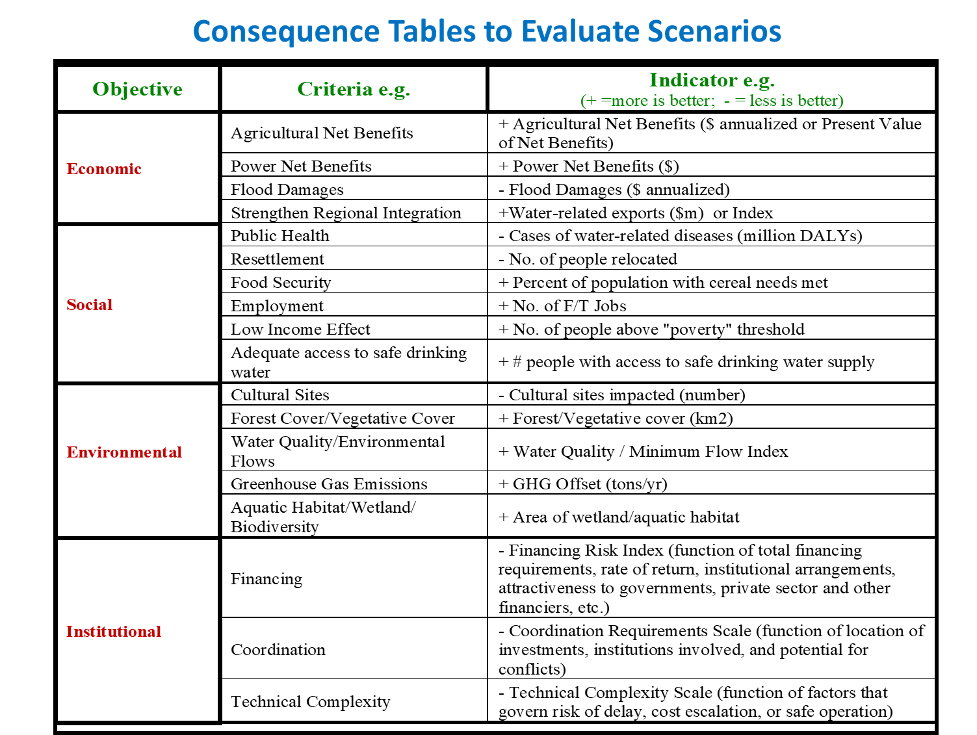
Source: Nile Work & add context – investment prioritization
Sometimes, these are reduced to indices constructed by weighting these indicators, but these are often difficult to communicate (although some like air quality indices have now become well-accepted). Another option is to leave these “consequence tables” of scenarios with actual numbers/rankings and see if the complexity can be reduced by highlighting to decision-makers the big picture implications of various scenarios on key indicators that are more sensitive (e.g., cost, benefits, environmental/social implications, implementation complexity).