Wang Chhu Basin IWRM
Wangchhu basin is the first basin to have the Integrated River Basin Management Plan since 2016.
Under The Wangchhu Basin Development Plan is a detailed climatic, hydrological, socio-economic, and institutional assessment which have been carried out to provide the socio-economic and environmental context of the Wangchhu basin. The plan aims to increase and sustain water security in the basin which will be monitored through Bhutan Water Security Index. The plan focuses on the importance of water security, pursued at the level of river basins, the plan defines five management basins namely i) Amochhu, ii) Wangchhu, iii) Punatsangchhu, iv) Mangdechhu and v) Drangmechhu
Basin Profile
Geospatial Analysis on indicators such as Elevation, Population, Land Cover etc. taken from World Bank Geospatial Platform
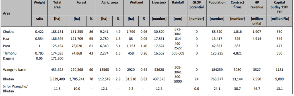
Wangchhu Basin Profile
Source: ADB
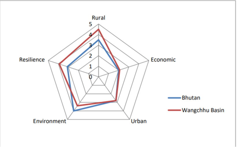
Water security index 2016: Bhutan and Wangchhu
Source: ADB
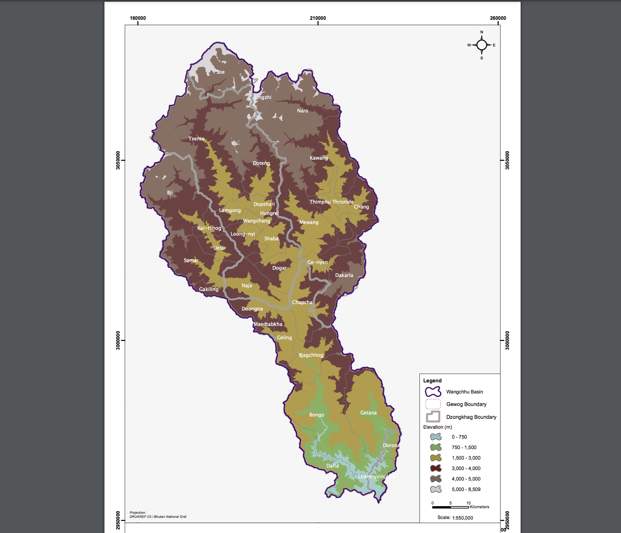
Geography
The basin is bounded to the north by China and India's south, as shown in the nearby figure. The basin drainage area is 4,624 kilometers (km)2. Elevation within the basin range from 750 meters above sea level (masl) to 5,000 masl as shown in the nearby figure.
Land Cover
Wangchhu land cover map shows geographical diversity in land type such as snow and glaciers, water bodies, shrub and grasslands, forest by type, agricultural and urban areas as shown in the map below.
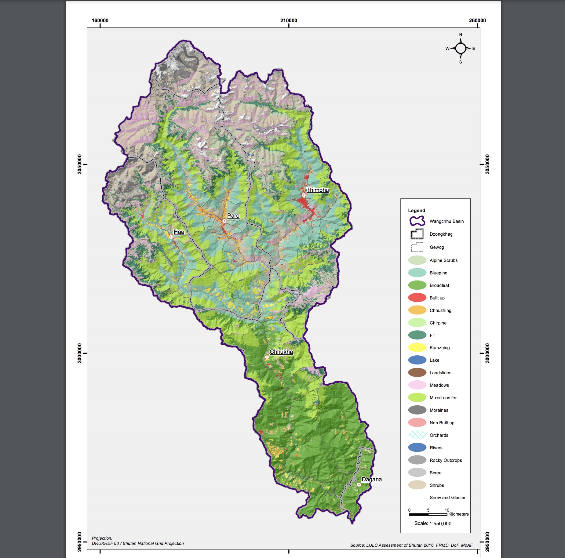
Wangchhu basin occupies 12% of Bhutan’s surface area. Per the IWRM approach, the Wangchhu basin comprises one drainage basin, which is also considered as one management unit. It was subdivided into 19 sub-basins for hydrological assessments covering four Dzongkhags (Chhukha, Haa, Paro, and Thimphu) and 30 Gewogs. The Wangchhu water security index system is an online water security database system that automatically generates water security information system for the five dzongkhags under the Wangchhu basin namely Haa, Paro, Chhukha, Thimphu and parts of Dagana. The Wangchhu basin has 58 glaciers. The Wangchhu basin has a total drainage area of approximately 3,550 sq. Km. The basin is equipped with one stream flow gauge at the outlet Chhukha Dam Hydrological station and five rain gauge stations. The northern periphery of the Wangchhu basin in the Himalayas has elevations over 6,000 m and maintains an annual snowpack. ( Fakhruddin, 2015 ). There are two large existing run-of-the river hydropower stations in Wangchhu basin at Tala (1,020 MW) and at Chhukha (336 MW). Run-off-the-river power stations divert river flow through their turbines and do not have a large reservoir.
Water Resources
Groundwater
A significant source of drinking water and irrigation is groundwater. A comprehensive baseline study has not yet been performed. An integrated multi-disciplinary approach involving geology, hydrogeology, geophysical techniques, groundwater tracing techniques and GIS/Remote Sensing would go a long way in assessing the groundwater potential of Bhutan.
Water Demands
Agriculture
The Wangchhu basin has 19,000 acres of land cultivated where the major food crops are grown: paddy, maize, wheat, barley, millet, and fruits and vegetables such as apple, orange, plum, and pear, cauliflower, etc. Approximately 5,400 acres are irrigated through a canal network, where 1,200 acres rely on water from the reservoir and rainwater harvesting. The remaining area uses season rain. A map of agriculture diversity is shown below.
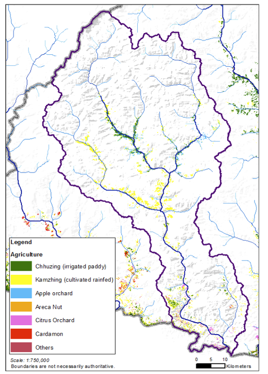
Source: Wangchhu Water Security Index Report (2017)
Water Infrastructure
Dams & Hydropower
There are 8 hydropower dams in the Wangchhu basin with an installed capacity 1357.61 MW. The location of the dams is shown in the nearby map.
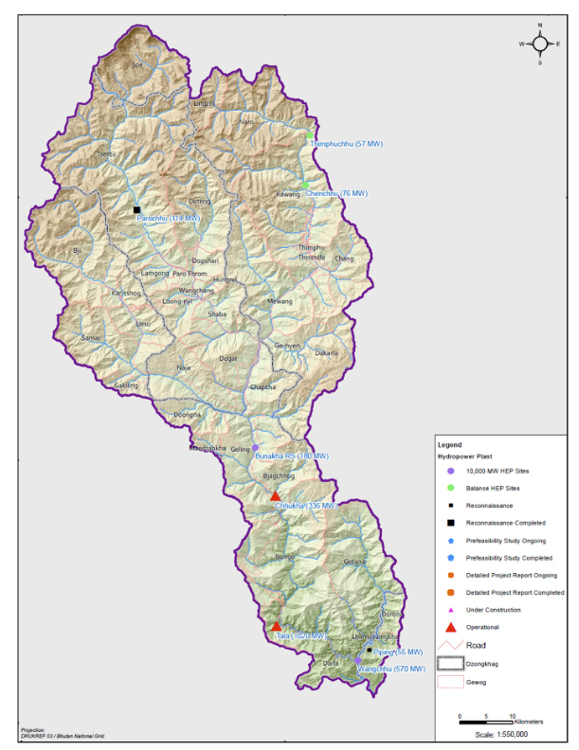
Source: Wangchhu Water Security Index Report (2017)
Key Issues
- Information Challenges
o Lack of adequate monitoring
o Lack of availability of data/ information and exchange, especially in the public-domain
o Lack of platforms to access key data, analytics, and insights
- Institutional Challenges
o Lack of coordination between agencies involved in or affecting water management.
o Lack of capacity of agencies involved in water management.
o Lack of capacity in local government to deal with their workload.
o Subordinate role of Water Users Associations.
- Investment Challenges
o Water quality in the basin is currently generally good but is deteriorating within and downstream of Thimphu and Paro urban centres. The causes of water pollution are car workshops spilling oil and wastewater, insufficient sewage water treatment, and solid waste disposal.
o Need for improved system storage to improve year-round water availability for growing use and buffer against climate shocks
Key Options
- Information
o Develop and implement a monitoring strategy for the entire Wangchhu basin to fill critical data gaps (e.g. on groundwater, water quality) and ensure availability of real-time data services
o Leverage available earth-observation and other tools (incl. from global sources) to support the development of insights
o Develop appropriate interactive dashboards and decision support systems to support planning and operational decisions across sectors
- Institutional
o Improving cross-agency coordination with an effective Wangchhu Basin organization
o Support the development of enabling policies for improved data access and use, including in the public-domain
o Improving capacity of agencies for water management through training, deputation into the Basin organization, student internships, virtual learning, etc.
o Improved interaction (including through use of technology) with local government and water user associations
- Investment
o Develop a comprehensive investment plan for the Basin including short, medium, and long-term options for water infrastructure (new and modernization) related to storage, efficient use, water quality management, and monitoring and institutional infrastructure
o Actively seek ways to finance investment needs with a combination of public and private resources
o Integrate climate considerations (both related to managing risks due to continuing climate variability and climate change scenarios) into the planning and operations of water-related infrastructure
Many of these are really options that could be explored throughout Bhutan in other basins as well.
Emerging Vision
According to the Wangchhu Basin Management Plan 2016, the following tables list the key result areas and key performance indicators along with the main interventions/projects.
Plan for Rural Water Security
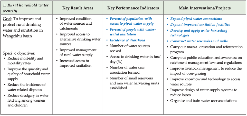
Source: Wangchhu Basin Management Plan 2016
Plan for Economic Water Security
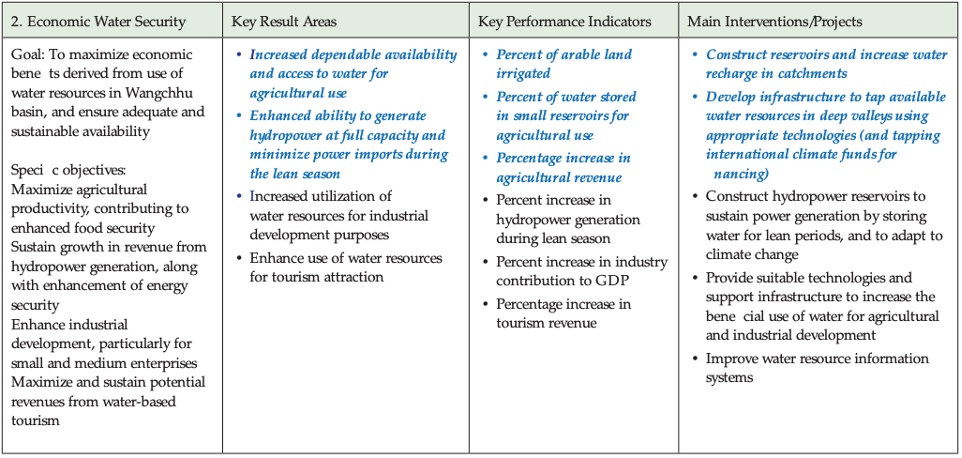
Source: Wangchhu Basin Management Plan 2016
Plan for Urban Water Security and Drainage
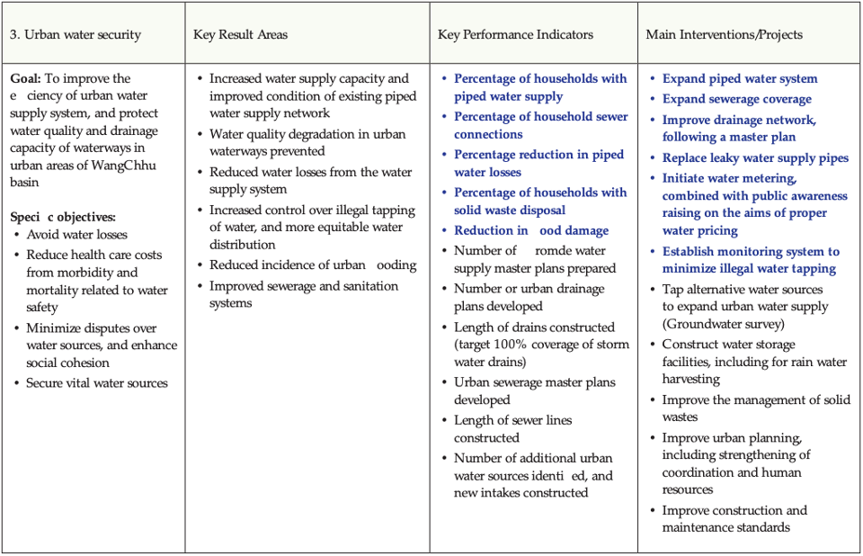
Source: Wangchhu Basin Management Plan 2016
Plan for Environmental Water Security
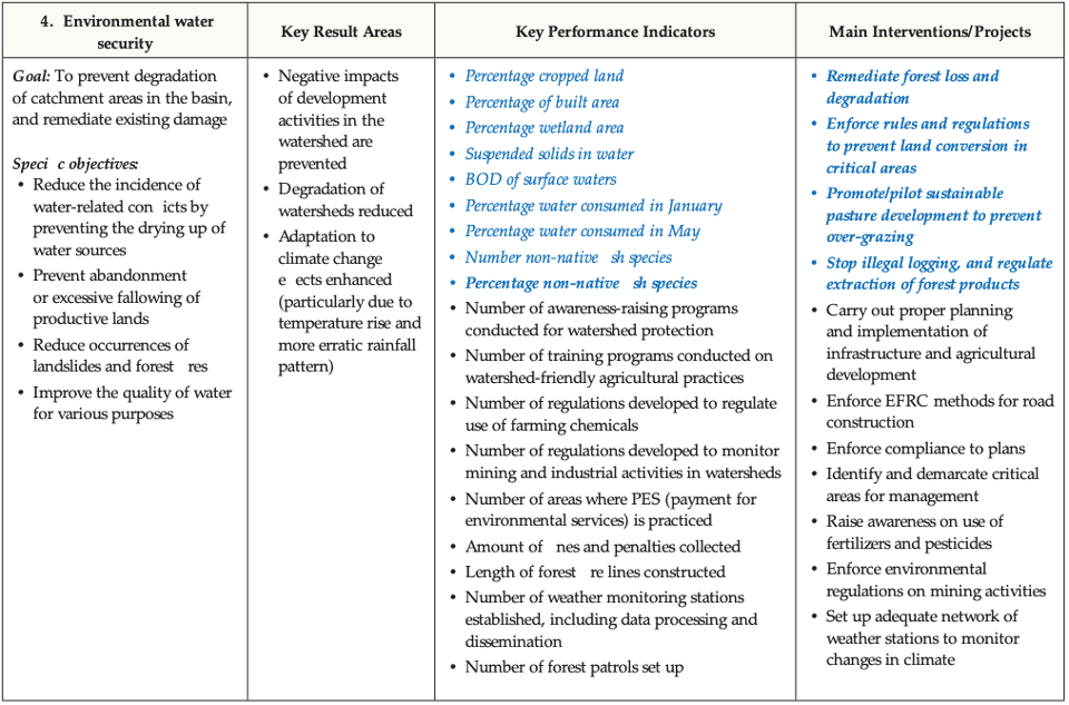
Source: Wangchhu Basin Management Plan 2016
Plan for Resilience to Disaster and Climate Change
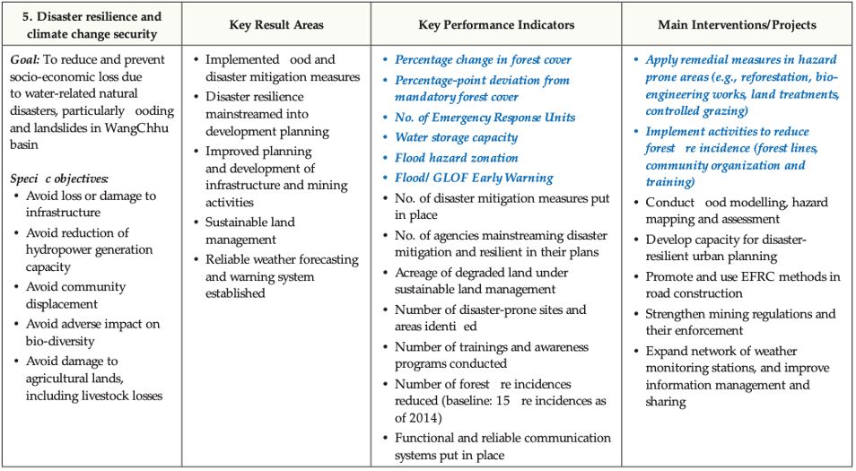
Source: Wangchhu Basin Management Plan 2016
Institutional Arrangements
Wangchhu River Basin Committee
River Basin Committee
The Water Act 2011 requires water resource management interventions to be pursued at the level of river basins. For this, a river basin committee (RBC) comprising of representative of stakeholder and competent authorities is to be established. The RBC with the help of its Secretariat, is responsible for coordination of planning, implementation, monitoring, and reporting progress towards water security in the basin. What the NEC is at the national level, the RBC is at the basin level. Bhutan is divided into five management basins namelyWangchhu, Amochhu, Punatsangchhu, Mangdechhu and Drangmechhu for management of water resources at the river basin level. The implementation of the NIWRMP was to be at the river basin level and for this the Wangchhu basin was prioritized for the pilot exercise.
The Wangchhu River Basin Committee
The Wangchhu basin committee was established on April 14, 2016 and was the first step in the formulation and implementation of the River Basin Management Plan (RBMP), known as the Wangchhu Basin Management Plan (WBMP). The operationalization of the Wangchhu Basin Committee and the implementation of the Wangchhu Basin Management Plan were supported by the Asian Development Bank till November 2019. The RBMP was prepared in accordance with the Water Act of Bhutan 2011, Water Regulation 2014, and the National Integrated Water Resources Management Plan (NIWRMP) 2016. The Wangchhu Basin Committee (WBC) was responsible for collection of local information, integration of water resources management plan of the Gewogs into the plan and ensuring that the WBMP was consistent with the principles and objectives of NIWRMP. The WBC functions as a coordinating body responsible for the preparation and updating the WBMP, integration of the priorities in respective district plans, monitoring the implementation of the plans and reporting on the level of water security in the basin.
Composition
The WBC comprises of chairpersons of the district development council ( Dzongkhag Tshogdu), district governors (Dzongdags), district environment officers (DEO) of the four districts of Chukha, Haa, Paro and Thimphu, the Environmental Officer, the Mayor (Thrompon) of Thimphu city and the Director of Department of Forest and Park Services, MoAF. The Chief Environment Officer (CEO) of the Water Resources Coordination Division, NECS functions as the member secretary of the committee. The committee is chaired by a Governor or Mayor which is rotated amongst the governors of the four Dzongkhags and the Mayor on a yearly basis. A key responsibility of the WBC is to report on the status of water security in Wangchhu basin to the NEC on a yearly basis.
Secretariat
Currently the Water Resources Coordination Division (WRCD) of the NECS functions as the interim secretariat to the WBC. The key responsibilities of the Secretariat in supporting the WBC are to: (i) coordinate with the concerned Dzongkhag administrations and national sectoral agencies to ensure that basin plan items are being implemented, (ii) facilitate conveyance of advisories or directives of the WBC to the district and Gewog administrations as well as collate responses (iii) facilitate networking and partnerships with NGOs, communities, state enterprises and private organizations operating in the basin and (iv) convene a consultative assembly to deliberate on the basin plan and on a need-basis consult stakeholders on specific water management issues that arise and have basin-wide implications.
The Dzongkhag Coordination Committee and the Thromde Coordination Committee
The Dzongkhag Coordination Committee (DCC) and the Thromde Coordination Committee (TCC) have a key role in coordinating and collecting data from the respective Dzongkhags and Thromdes for the Wangchhu Water Security Index (WWSI). The DCC and TCC are comprised of Dzongkhag Environment Officer (DEO), Statistical Officer (SO) and Planning Officer (PO). The DCC and TCC are the focal points for the collection of data at the basin level. The first WWSI report was developed in 2017 and the overall score for Wangchhu basin was 3.9 which meant that the water security status in the basin was in a capable stage. This score helps policy and decision makers to focus on areas that require greater attention and introduce interventions accordingly. Currently, there are no sub-basin units within the Wangchhu basin.
Review and Follow-up to WBMP of 2016
A review was carried out by the ADB to assess the initial experience of the operationalization of the WBMP, following which the Technical Assistance supported the WRCD in further strengthening the operationalization of the WBMP. This was carried out in the following key areas:
- Aid the implementation of the basin plan by reviewing the WBMP 2016 by holding consultation meetings and having a re-look at the water related issues at the district level. The WBMP was revised with minor changes.
- Integration of water security into the national 12th FYP. A series of workshops were held where the process of integrating water priorities into the five-year planning process and linking with national key result area (NKRA), agency key result areas (AKRA) and local government key result areas (LGKRA) were deliberated. The NKRAs, AKRAs and LGKRAs were then presented to the Water Resource Technical Advisory Committee (WRTAC).
- Operationalization of Wangchhu Basin Committee (WBC): the TA also supported the NEC in operationalizing the WBC with the following activities: conducting 8 WBC meetings, roadmap for the establishment of WBC secretariat, exposure trips to Japan and Thailand for WBC members, developing and application of WBC performance benchmarking system and producing the Wangchhu Basin Water Security Index.
The main financial support for the operationalization of the WBMP was from ADB. However, since 2019 the operation and sustaining of WBC activities is through the annual funds from the Royal Government of Bhutan. NECS as the interim secretariat has the role of facilitating resource mobilization from other funding agencies and donors. The WRCD of the NEC is responsible for the integration of the WBC budget into the NECS annual budget.
Integration of water security priorities into sectoral plans at national and local government levels
The broad concerns and issues of various sectoral ministries and agencies are identified in the National IWRM Plan (NIWRMP) and the River Basin Management Plans (RBMP). Accordingly, these two documents are supposed to be the reference documents for identification of water priorities and formulation of National Key Result Areas (NKRAs), Agency Key Result Areas (AKRAs) and Key Performance Indicators (KPIs) for the upcoming FYP i.e., the sectors are expected to use the NIWRMP as a reference for identification of NKRAs, AKRAs and KPIs while Wangchhu Basin Management Plan (WBMP) is expected to be used for formulating Local Government KRAs (LG KRAs) and KPIs based on interventions identified therein. For tracking progress towards water security, the district and Thromde administrations are to collect the data for the indicators and parameters that are specified under key dimensions and sub-key dimensions of the WWSI. The WBC secretariat is then expected to consolidate, analyse the data, and publish the water security status report. It is envisaged that the WRCD of NECS is to consolidate the water security information of Wangchhu basin and all other basins into the national level Water Security status report.
The integration of water security priorities into sector plans at national and local government level is done at the time of formulating the FYP. For the 12th FYP, an attempt was made to demonstrate the entire process of identifying water priorities for each of the five key dimensions of water security. The first attempt was to incorporate ‘Water Security’ as a National Key Result Areas (NKRA), although many water related priorities may fit better under other NKRAs. For the 12th FYP, the WRCD staff supported by ADB TA had conducted a series of district level workshops, consultations, and trainings for Wangchhu districts to integrate WBMP priorities into 12th FYP. Based on the interventions identified in the NIWRMP, the NKRAs, AKRAs, LGKRAs (for Wangchhu Basin Districts) and KPIs were formulated for the 12th FYP. Despite the efforts, the proposed NKRA, AKRAs, LGKRAs and KPIs did not feature in the final 12th FYP. This indicates inadequate awareness and acknowledgement from GNHCS and concerned water related agencies. In the absence of top-down approach to integrating water security into national plans, cooperation and coordination is affected by silo approach to water resource management.
Key Challenges
Gaps between adoption and implementation
The Wangchhu Basin Management plan 2016 highlighted the following challenges:
- Lack of coordination between national ministries and its agencies in water management.
- Capacity constraints of agencies and local governments
- WUAs not given adequate prominence.
- Lack of data, information, and its sharing with critical stakeholders
The Wangchhu Water Security Index Report of 2017 further highlighted the following constraints:
- Limited technical capacity of the different agencies in providing quality data.
- Lack of technical expertise along with required equipment to generate important data like meteorological information and water quality.
Currently these issues remain due to lack of adequate government financing and sufficient human resources. The dependence on donor funded projects and the prevailing COVID-19 pandemic and its associated restrictions since early 2020 have had its adverse impacts in addressing these challenges and operational momentum of the WBC.
Lack of a dedicated WBC Secretariat: For the sustainability of the WBC, the need for and importance of a dedicated WBC secretariat has been raised and reiterated periodically during several meetings of the WBC. To this effect, even a roadmap for establishment of the Secretariat was prepared so that WRCD, NECS could take it up with the Royal Civil Service Commission. Owing to lack of dedicated WBC Secretariat, the WRCD was identified as the interim WBC Secretariat. To this day, there is neither an independent Secretariat for the WBC nor does WRCD as the interim Secretariat have dedicated staff to support the WBC. This dedicated secretariat will also need to be adequately staffed to carry out the functions effectively. With the COVID-19 pandemic, the efforts made in this direction have yet to materialize.
Integration of data for the WWSI: A framework for WWSI data collection was developed. Based on this document, the concerned staff of the four district administrations in the Wangchhu basin was trained. The district level coordination committee for WWSI data collection comprise of the District Environment Officer, the District Planning Officer, and the District Statistical Officer. The process of data collection, entry into WWSI system and reporting was demonstrated for 2017. In the absence of a dedicated WBC Secretariat, an already overwhelmed interim Secretariat, and the COVID 19 situation, the WWSI report for 2018 could not be published.
Some of the early concerns of the WBC on the WBMP were the following:
- Where resources are not available to achieve targets set in the WBMP, these should not be binding for implementation by the Dzongkhags and Thromdes in the basin.
- In the context of annual budget ceiling in local governments, there was limited provision for incorporation of the WBMP activities in the local government plans.
Recommendations
Consistency in the operation and functionality of WBC is found to be most wanting. Although the COVID-19 pandemic has hampered the functionality of WBC, it may be said that the financial and human resource allocation for operationalization of the WBC is inadequate which makes the IWRM implementation more superficial than practical. In view of this, the following are recommended:
Resource commitment : Adequate financial resources for operationalization i.e., to support regular WBC meeting needs to be mobilized or provided by the government.
Need for river basin committee secretariat: Within the scope of above need for adequate financial and human resources, the need for an independent Secretariat for a basin committee seems essential. In the absence of a dedicated Secretariat and an overstretched WRCD as the interim Secretariat, there is barely any progress with implementing of IWRM in the Wangchhu basin. Setting up of independent basin committee secretariat is therefore a priority.