Integrated Water Resources and Watershed Management
Water security is a major – and growing – challenge for many countries today. The global population is growing fast, and estimates show that with current practices, the world will face a 40 percent shortfall between forecasted demand and available supply of water by 2030. Furthermore, chronic water scarcity, hydrological uncertainty, and extreme weather events (floods and droughts) are perceived as some of the biggest threats to global prosperity and stability.
Feeding 9 billion people by 2050 will require a 60 percent increase in agricultural production, (which consumes 70 percent of water resources today), and a 15 percent increase in water withdrawals. Besides this increasing demand, the resource is already scarce in many parts of the world. Estimates indicate that 40 percent of the world population live in water scarce areas, and approximately ¼ of world’s GDP is exposed to this challenge. By 2025, about 1.8 billion people will be living in regions or countries with absolute water scarcity. In many regions, water withdrawals continue to increase due to growing competing uses (industrial, domestic, irrigation), as well as to persistent water use inefficiencies and low productivity, particularly where the resource has been historically plentiful or its price heavily subsidized. Catchment degradation leading to increased erosion and sedimentation, affecting runoff and infiltration processes are further hampering secure access to reliable water supplies. In addition to the already highly variable (temporal and spatial) distribution of freshwater availability in most contexts, water quality is a compounding challenge with cascading impacts on the environment, health, and the economy.
Continuing climate variability and emerging climate change concerns in the context of growing populations and water demands are expected to exacerbate the situation by altering hydrological cycles, increasing system losses, making water more unpredictable, increasing the frequency and intensity of extreme events such as floods and droughts. The approximately 1 billion people living in monsoonal basins and the 500 million people living in deltas are especially vulnerable. Flood damage is estimated at $120 billion per year (only from property damage), and droughts pose, among others, constraints to the rural poor, who are highly dependent on rainfall variability for subsistence.

One of the challenges in water systems is a culture of “data-free analysis and analysis-free decision making” that thrives in an environment of data access, capacity, and governance challenges. Adequate information is critical to monitor trends, understand the essence of water problems today, and inform solutions accounting for future challenges and opportunities. Water Information systems are needed to support water resources monitoring and system analysis, as well as to inform decision making under uncertainty and for hydro-meteorological forecast and warning.
Achieving effective water information systems is however not an easy task, because water systems are complex due to the interrelation of composite hydrological processes with social, environmental, and economic factors across spatial and temporal scales. In-situ monitoring data (e.g., on water levels, flows and water quality) is often inadequate in spatial and temporal coverage to get a full understanding of a river basin or aquifer and spread over multiple institutions. Most importantly, institutions are reluctant to make relevant and timely information available in the public domain especially when transboundary issues are involved within and across countries and where there is no e-governance demand for transparency and accountability. There is a lack of integrated decision support system tools for planning and system operations to create a demand for regular, real-time, and curated data services integrated across institutions.
Many countries and regions continue to struggle to put in place even basic modern generation water information systems and hence face shortcomings across the hydroinformatics data value chain: from online services of timely and reliable observations, processing, and management of data to the generation of information products and their dissemination/access to users who then take decisions/actions based on the analytical insights. The most pressing challenges are often driven by the lack of awareness of the benefits that improved hydro-met information by central and regional governments. Budget allocations to sustain such services and investments to upgrade and expand existing capacities are therefore rarely prioritized. Fragmented, unclear, or limited institutional sector frameworks further compound common operational barriers (i.e., restricted/poor data sharing across agencies and boarders, lack of O&M (Operations & Maintenance) guidelines and standards, services inefficiency, etc.). Many solutions (e.g., information systems, modeling tools, institutional arrangements) are often in a disjointed “
The new world of “disruptive” technology and the recent rise in digitalization, accelerated in the context of the COVID-19 pandemic, provides new insights of possibilities to support decisions for promoting more integrated water resources planning and management. Disruptive technologies are helping narrow the gap in terms of water resources data generation with global satellites, Internet of Things (IoT), and crowdsourcing, as well as analytics applied to water-based systems by leveraging from more automated and web/cloud-based data assimilation platforms, online models, and machine learning. These technologies can provide real-time as well as predictive information for many practical applications and many products and tools can be accessed for free.
Role of HydroInformatics
HydroInformatics is the use of modern data, analytics, knowledge, and communication to provide insights to better monitor, plan and manage water resources in a holistic manner for an appropriate system (e.g., watershed, aquifer, country, trans-boundary basin). It offers a portal to explore how a wide range of emerging digital technologies and innovations for data gathering analysis and modelling can be deployed to help solve challenging water information problems. These are slowing moving from retail-level applications for specific elements of water systems to broader flexible systems that can leverage a range of services.
Very often water information services are composed of standalone products with a distinct application that captures a specific element of the water system. HydroInformatics has emerged in fact to help end-users overcome having to solve individual tasks in different systems, comply with different requirements for input data, as well as deal with complicated handling of outputs to produce useful visualizations of results. As such, Hydroinformatics combines the application of available data/information, simulation and decision-making models, and communication technologies to support informed sustainable planning and management of water resources.
So, what are the key types of Hydroinformatics data? Data sources for hydroinformatics encompass all measured elements (from in-situ stations and remotely sensed) of the water cycle: precipitation (rainfall, snowfall, hail), snow accumulation, glaciers, river flows, water levels, soil moisture, groundwater, water quality, and climate (air temperature, humidity, etc.). Data sources are not only limited to the physical water balance components (precipitation, evaporation, and runoff) but include other environmental conditions (soil, land use) and information on key water users and demands (agriculture, hydropower, industries and domestic), as well as any other economic and social conditions.
Today, it is possible to access most Hydroinformatics data by leveraging emerging global data sources: Sentinel satellite imagery and derived products useful to determine vegetation and water content, pollution in lakes and coastal waters, glacier monitoring and flood mapping; GPM and CHIRPS rainfall historical series; GEOGLOWS streamflow historical and forecast estimates, Climate Engine’s actual ET estimates; and many other datasets available from WMO , NASA SERVIR , NOAA , USDA G-REALM , ESA Copernicus , Dartmouth Flood Observatory , IRI /Columbia University, KNMI , IPCC , UNISDR , UN Data , ECMWF , GLOFAS , GEOGLOWS , IPCC , UNFCCC , Google, IWMI , IGRAC , World Bank, and others: GADAS/USDA for weekly soil and sub-surface soil moisture estimates, IRI/Columbia University for seasonal forecasts, the Climate Analytics/Princeton University for global drought and flood monitoring; NOAA/NWS; GEE analytics, Aqueduct Food Site/WRI for global irrigated and rainfed crop producing areas, and a growing range of subscription services. All this data and analytics can be made accessible to users as well as enable rapid analytics through user-friendly platforms (e.g., the World Bank’s evolving HydroInformatics Platform and the internal World Bank Geospatial Platform and interactive dashboards customized to different users.
“Disruptive” Technologies
There are a range of rapidly evolving technologies that have the capacity to “disrupt” traditional hydroinformatics approaches.
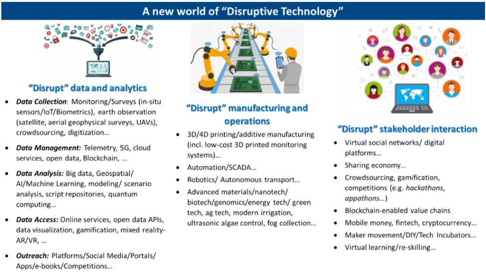
There are an exciting set of opportunities to address the traditional challenges of water resources and to help better connect to global good practices.
Countries around the world are finding how the use of technology can automate effective monitoring and provide accurate data for better planning, for effective decision making at all levels. Artificial intelligence and big data provide a means for real time monitoring and analysis of data, which can be accessible via smartphones and other platforms for policy makers and citizens.
The use of sensors in every setting will help us move towards an Internet of things (IoT) operationalization. These will be complemented with crowdsourcing (in structured and unstructured ways) of data from people (e.g., mobile Apps), and the leveraging of increasingly powerful remote sensing technologies such as satellites and drones. These will give us a new holistic perspective not only of water resources, but of the natural and anthropogenic context under which water resources are generated, stored, managed, used, and disposed. This will lead to interfacing in data systems between natural resources (e.g., weather, flows, glaciers, snow, surface and ground waters, water quality, watershed characteristics) and their use (e.g., storage in dams, flows in pipes, soil moisture in agricultural fields, etc.) for a more comprehensive management of issues of efficient and sustainable water use, water infrastructure planning and operations, reducing losses, and managing climate risks.
More information on this growing world of new technologies here (Especially see interactive examples)
These technologies can help us rethink all aspects of water resources planning and management. They can help with collecting and analyzing data, visualizing these in interactive dashboards and connecting people in innovative ways to support decisions. They can help modernize institutions and how they work to serve their clients. And they can help us explore future development and climate scenarios to visualize and prioritize investment planning and facilitate coordinated and more optimal system operations. Most importantly, the opportunity to contribute to, and build on, a growing range of online services can help everyone access relevant information in a customized manner to improve awareness, develop a shared vision, and benefit from each other’s work. Emerging approaches to creating “ digital twins ” of natural systems (e.g., basins/watersheds) and infrastructure (e.g., dams, urban water supply and sewerage systems) that offer a digital equivalent of the real system can help different stakeholders work together on these systems.
The water sector faces increasing pressures especially due to the impact of climate change. In the developing world governments will have to increase resilience and sustainability within the sector, within water scarcity and safety, water efficiency, operations of utilities, the treatment and monitoring of water resources and the generation of data and analytics, technology will play a critical role. Globally, there is a growing willingness to test and adopt some of these new technologies among utilities and operators; technologies such as remote sensing of water which can help with water accounting, non-revenue water remediation, artificial intelligence and big data also offer the capability now to analyze large volumes of water data to aid in decision support and policy making for the sector, in the area of water in agriculture, the internet of things is also enabling smart irrigation for efficient use of water.