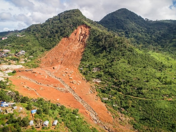
Landslide in a hilly area of Nepal. Photo: World Bank
Landslides are a leading cause of loss of life and damage globally. A recent study on the global patterns of loss of life due to non-seismically induced landslides estimated that 2,620 fatal landslides occurred globally in the period 2004-2010, causing 32,322 fatalities with a concentration of human loss in the Himalayan Arc and in China. (Petley 2012) A later study analyzing a global dataset of fatal non-seismic landsides from 2004-2016 found 4,862 landslide events that killed 55,997 people, with Asia having the largest concentration of events. (Froude and Petley 2018) Global landslide hazard data recently released by the World Bank estimates that roughly 400,000 significant rainfalltriggered landslides and 130,000 earthquake-triggered landslides occur per year globally. UNISDR estimates that between 1998 and 2017, over 5% of all disasters globally were landslides, affecting nearly 5 million people. Further, landslides, volcanic activity and mass movements led to US$ 8 billion in damages in this period. While landslides are distributed across the globe, South Asia is a hotspot for landslide activity and for loss of life and damages due to landslide events.
Distribution and number of reported fatalities associated with over 11,000 rainfall-triggered landslides from the NASA Global Landslide Catalog, which is available from 2007 to present. White dots represent incidents with zero reported fatalities. Dots in the color scale from pink to red represent incidents with fatalities in the range of 1-5000. These data are accessible at: https://landslides.nasa.gov/viewer
Landslide events are likely to increase in the future due to climate change and human activity. Geohazards, of which landslides are a type, are “…events caused by geological, geomorphological, and climatic conditions or processes which represent serious threats to human lives, property, and the natural and built environment”. (Solheim et al 2005) Landslides can be triggered by a variety of factors, including both geophysical (earthquake) and hydrological (precipitation above a threshold, extreme precipitation, flooding) events. In the 2019 Global Risks Report, the World Economic Forum lists extreme weather events as being both the most likely and the most impactful to societies across all economic, environmental, geopolitical, societal and technological risks. While extreme weather events, especially intense precipitation events, are likely to increase landslide occurrence, other anthropogenic factors will also place an increasing role. A recent study concluded that landslides triggered by anthropogenic activity are increasing, especially from construction, illegal mining and hill-cutting, and may have a greater impact on future landslide occurrences than will climate. (Froude and Petley 2018). Recent research in a the Calabria region of Italy suggests that rainfall-induced landslides may increase by almost 50% in the next 80 years due to increasing temperatures ( Gariano et al 2015
Identifying and managing landslide risk is critical to development activities. Identifying and managing landslide risk is critical to reduce loss of life and damage to property and infrastructure. Landslides interface with numerous sectors, both impacting and being impacted by activities in the forestry, agriculture, water, transportation, housing and urban sectors. Anthropogenic land use changes, such as deforestation and conversion to agriculture, improper road construction, and construction of dwellings or agricultural cultivation on steep slopes can increase landslide risk both locally and at larger geographic scales, while landslides can damage critical infrastructure and increase sediment loads in waterways, with adverse impacts to water quality and hydropower facilities in the watershed. Landslides cause direct impacts, such as loss of life and injury to people and extensive damage to structures and infrastructure, but also indirect impacts due to the “vulnerability shadow” they cast by disrupting connectivity of the road and transport network and therefore the movement of goods and people. These indirect impacts can be quite significant, impacting employment, schools, and health, and can ripple far beyond the sometimes-small local area of the landslide itself. (Winter et al 2016)
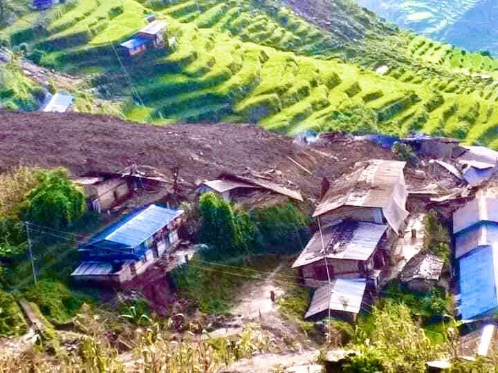
Landslide in Nepal. Photo: World Bank
Landslide risk management is critical to protecting people and economies. Landslide risk management is a two-step process. First, a landslide risk assessment (LRA) is conducted in which in which areas at higher risk of slope failure are identified. LRAs can be implemented at varying levels of complexity and sophistication, and at various scales from a single hillslope to a watershed. Second, a landslide risk management plan is developed based on the outputs of the LRA, which detail areas at higher risk for landslides. The landslide risk management plan incorporates methods for risk avoidance, management, and mitigation that will be effective in reducing risk given the social and environmental conditions of the specific areas at risk.

Nature-based solutions can be part of integrated solutions for landslide risk management at multiple scales. As noted previously, this guidance defines NBS as ““actions to protect, sustainably manage, and restore natural or modified ecosystems that address societal challenges effectively and adaptively, simultaneously providing human well-being and biodiversity benefits.” ( Cohen-Shacham et al 2016 as cited in World Bank 2019 ) Green infrastructure is a subset of NBS, “…that intentionally and strategically preserves, enhances, or restores elements of a natural system to help produce higher-quality, more resilient, and lower-cost infrastructure services.” ( World Bank 2019 )
Landslide risk management methods have historically focused on engineered grey solutions, such as retaining walls, soil nailing, and horizontal drains, to reduce landslide risk. Increasingly, NBS are being considered in integrated or “hybrid” landslide risk management plans that combine grey and green. NBS can be implemented at various scales, and for landslide risk management typically involve forest conservation and/or afforestation at the watershed scale, and vegetative plantings and other vegetative features at the hillslope or site level. In addition to reducing landslide risk by increasing slope stability, NBS are often cheaper and have myriad social, environmental, and economic co-benefits that grey infrastructure does not. Due to co-benefits, NBS can often increase the resilience of grey infrastructure.
This guidance note seeks to explain how LRA can be coupled with NBS to prioritize the use of NBS across a landscape for landslide risk reduction. A key barrier to mainstreaming NBS as a landslide risk management method is limited information on the value and cost-benefit of green vs. grey solutions for this particular disaster type. Landslide risk assessments provide an opportunity to embed the cost-benefit of NBS within the larger analysis to both identify the value of NBS and the locations in which NBS may be the cost-effective option, either in isolation (e.g. protecting, planting or restoring forests at the watershed scale) or in integrated solutions (e.g. vegetative plantings above and around grey infrastructure solutions). This guidance note seeks to highlight key criteria for determining where and how NBS can be helpful in landslide risk management through exploring key tenets of landslide risk assessment, and possibilities for the integration of NBS into landslide risk assessment and management through reviewing selected key case studies.
NBS for landslide risk reduction is a growing field but barriers to greater implementation remain. While grey engineering methods are commonly used for landslide risk reduction, NBS are gaining traction as a potential cost-effective solution both on their own and as a component of integrated solutions. NBS for landslide risk reduction include investments at multiple scales, including conserving, restoring, or managing forests at the watershed-scale to vegetating slopes at the project site scale. The evidence base on the use, technical implementation, and effectiveness of NBS in mitigating landslide risk is growing, including detail on plant selection and risk mitigation at different scales. Information on case studies of NBS implementation for landslide risk reduction is also increasing.
Literature on use and implementation of NBS solutions for landslide risk reduction include:
- Kalsnes and Capobianco 2019. Nature-based Solutions: Landslides Safety Measures . Klima 2050 Report No. 16.
- Kumar et al 2021. Nature-based solutions efficiency evaluation against natural hazards: Modelling methods, advantages and limitations .
- Ganepola et al 2020. Site Suitability Analysis for Nature-Based Landslide Risk Mitigation .
- Nehren and Mojica 2021. Nature-based solutions to mitigate the risk of shallow landslides: a global analysis .
However, barriers to greater implementation of NBS for landslide risk reduction remain . NBS for landslide risk reduction remains an evolving field, with outreach and knowledge sharing necessary to increase the understanding of and uptake of these methods. A key barrier to mainstreaming NBS as a landslide risk management method is limited information on the cost-benefit comparison between NBS solutions and traditional grey infrastructure solutions, which have a longer track record.
This guidance note aims to address these knowledge gaps. Other recent relevant guidelines in this area include:
- ASEAN Guideline On Integrating Climate Change Projection Into Landslide Risk Assessments and Mapping ( ASEAN 2021 )
- Sri Lanka NBS for Landslide Risk Management ( World Bank 2019 )
Recent examples of landslide damage in South Asia
South Asia is particularly vulnerable to geohazard and landslide risks. A combination of geohazard susceptibility (topography, climate, land use, high seismic activity and monsoonal rainfall), economic growth and development in a variety of sectors, urbanization and climate change are increasing South Asia’s vulnerability to high economic, social, and environmental costs of disasters. According to a recent Bank report , South Asia reported 1,017 disasters between 1971 and 2009 that met EMDAT criteria, with the absolute number of reported disasters increasing from 8 in 1971 to 40 in 2009. These disasters resulted in over 800,000 deaths, affected over 2 billion people, and led to direct economic losses estimated at over US$ 80 billion. (World Bank 2012)
Within South Asia, landslide events are concentrated in the Himalayan region, though they occur along the West coast of India as well. The figure below shows a landslide hazard map for South Asia, with higher landslide hazard evident in these regions. Landslides within the region result from a variety of factors, including naturally unstable slopes resulting from the topography of the region, high tectonic activity (earthquakes), a monsoonal climate marked by intense rainfall events and associated flooding, and glacial lake outburst floods (GLOFs). The impacts of these natural processes have been intensified by anthropogenic activity, including road construction and alteration (widening), human settlement (construction) and agricultural cultivation in landslide prone areas, and deforestation.
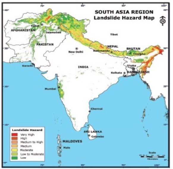
Landslide Hazard in SAR. Source: RMSI 2010.
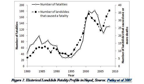
In the 21st century South Asia has been hit by a number of devastating landslides. The landslide-prone state of Kerala in India experienced a large landslide in Amboori in 2001 . This occurred when above average monsoon rainfall triggered a landslide on a slope that had been impacted by road cutting and agricultural cultivation, and killed 38 people. The 2007 Chittagong landslides in Bangladesh were triggered by monsoonal rains on slopes also impacted by hillside cutting and killed more than 130 people. In 2010, the Hunza Valley landslides in Pakistan killed 20 people, and also blocked the Hunza River, which created a lake that blocked the Karakoram Highway, flooded homes, and displaced 1,500 people. In June 2013, heavy rainfall combined with the bursting of the Chorabari glacier moraine in Uttarakhand , and resulted in flash floods, extensive landslides, and debris flow. More than 5,000 people were reported missing, 4,200 villages affected, and 3,000 homes destroyed. More than 1,000 public buildings, 9,000 km of roads and 225 bridges were damaged. (See India Disaster Report 2013) In 2014, two mudslides in Badakhshan Province, Afghanistan killed over 2,000 people. Badakhshan Province experienced another landslide in 2015 that killed 52 people. 2017 was the worst year of landslides in Bangladesh’s history, with 152 people killed in landslides in Rangamati, Chittagong and Bandarban. In Nepal, over 40% of disasters are comprised of landslides and floods. The 2015 Gorkha earthquake in Nepal killed nearly 9,000 people and injured almost 22,000. Further, landslide fatalities in Nepal display an increasing trend, due in part to anthropogenic factors: population growth, urbanization and land use change. A recent study hypothesizes that the increase could be driven by increased settlement close to roads in valleys, where impacts from landslides are greatest.
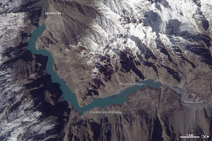 Satellite image of 2010 landslide in the Hunza Valley, showing the location of the lake that resulted
from blocking of the Hunza River. Source: Nasa Earth Observatory.
Satellite image of 2010 landslide in the Hunza Valley, showing the location of the lake that resulted
from blocking of the Hunza River. Source: Nasa Earth Observatory.
Landslide damage in South Asia can be significant. The Jure landslide of 2014 in Nepal in Nepal led to 155 deaths, 157 homes destroyed and led to estimated economic impacts of millions of Nepali rupees due to loss of connectivity and trade disruption. Damages from a landslide that occurred in 2010 in the Almora District of Uttarakhand, India included over 40 deaths and over $125 million USD in damages to houses, schools, agriculture and transportation infrastructure.