
In Phase 3, the outputs of the LRA completed in Phase 2 are used as inputs to the landslide risk reduction strategy. In this phase, the project team can assess how NBS may be used to address the landslide risk identified in Phase 2. This can be accomplished if the outputs of Phase 2 provide the team with a spatially explicit assessment of landslide risk and the drivers of that risk. Especially helpful is a cost-benefit analysis of various potential solutions to reduce risk that can point the team to the cost-effective ways of reducing risk in a spatially explicit way. Landscape-scale LRAs will also have indicated areas outside of the project area that could impact on drivers of landslide within the project area; these external areas may be indicated for NBS solutions such as protection forests.
In phase 3, the team can look at developing an NBS risk strategy in the context of integrated solutions that include both structural and non-structural solutions tailored to the sector of concern (e.g. DRM/roads/watersheds) and the scale at which the assessment was done. Phase 3 evaluates the solution space and selects elements for the landslide risk reduction strategy based on analysis of the technical suitability and cost-effectiveness of various solutions in reducing risk.
Key questions answered in Phase 3
- Is NBS a possibility for landslide risk reduction for my project?
- Where in the project area or larger landscape might NBS be implemented alone or in combination with other measures?
- What specific NBS and other mitigation measures can be implemented in the project area and surrounding landscape to reduce risk?
Question 1: Is NBS a possibility for landslide risk reduction for my project?
A decision tree for selecting whether to consider NBS within a project is below. The sections that follow provide progressively more detail on criteria the team could use to determine where and how to use NBS for landslide risk reduction.
To answer the first question on whether NBS is a possibility for landslide risk reduction in the project area, the team can use the decision tree below.
Decision Tree for NBS Consideration for Landslide Risk Reduction
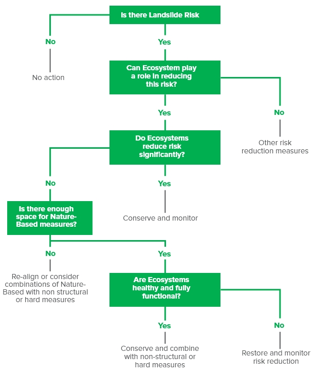
Source: Adapted from World Bank, Nature-Based Flood Protection Guidance 2017
Question 2: Where in the project area or larger landscape might NBS be implemented alone or in combination with other measures?
Once the project team has determined that NBS could be a potential solution to reduce landslide risk in certain areas, detailed assessment of where and how NBS can be implemented can start. Detailed results from both the LRA and cost-benefit analysis are important to decision-making. LRA allows for the classification of the project area and the surrounding landscape into low/medium/high landslide risk in a spatially explicit manner (or in other categories that are more nuanced, data permitting). Cost-benefit analysis provides information on where risk reduction measures, including NBS, may be most cost-effective. The table provides a framework for determining where NBS solutions can be implemented based on relative risk level and existing protective measures.
The table shows that the team may consider NBS for resilience where risk reduction needs and risk reduction measures are both low, or where these two factors are both high. The team may consider integrated solutions, involving both avoidance and NBS/green and gray measures in those areas where landslide risk is high but where existing risk reduction measures are low. It is important to note that in high risk areas without sufficient existing risk reduction measures, NBS is most likely insufficient to effectively reduce risk to acceptable levels. Finally, areas with low risk but a high level of risk reduction measures may not require any NBS or other risk reduction measures.
Identifying NBS Opportunities on the Landscape Given Landslide Risk Reduction Supply and Demand
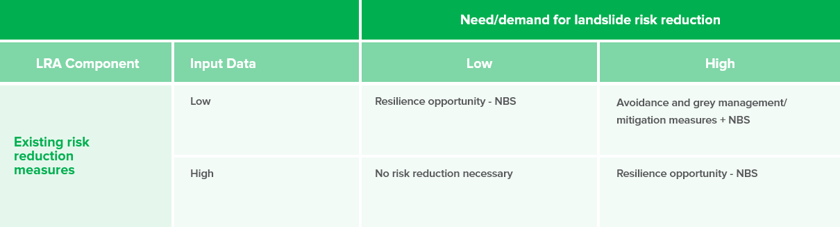 Source: Adapted from Accastello et al 2019
To further identify potential areas for NBS/green infrastructure or hybrid solution implementation, the project team could use a multi-criteria assessment at the highest resolution possible for the project. An example of an multi-criteria assessment is provided from a recent Bank project on landslide risk management in Sri Lanka.
Question 3: What specific NBS and other mitigation measures can be implemented in the project area and surrounding landscape to reduce risk?
Next, the team can consider which specific NBS measures to consider for specific areas of NBS opportunity as identified in the table above. In evaluating different risk reduction measures, the team needs to consider (1) landslide characteristics (e.g. movement types, materials and rates) in the project area and in areas of the landscape that affect the project area; (2) effectiveness in reducing risk; (3) socioeconomic and environmental constraints (e.g. engineering and economic feasibility; social and environmental feasibility); and (4) costs.
Landslide risk can be reduced through avoidance, management, and/or mitigation measures. Within each of these categories, a broad array of methods to reduce landslide risk exist. Risk avoidance is a precautionary method that restricts people and development (e.g. housing and infrastructure construction, agriculture) from high-risk areas, thereby reducing exposure of people and assets at risk. This can be accomplished through land use planning and zoning, risk-informed project siting, and early warning systems.
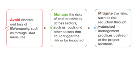
Mitigating landslide risk seeks to reduce the vulnerability of people and assets at risk through risk communication, signage, and some grey and nature-based solutions.
Mitigating landslide risk involves direct methods of preventing landslides from occurring in areas that have a moderate level of landslide hazard, or areas that may have high risk but where avoidance is not possible or feasible. Mitigation measures works by increasing the resisting forces or decreasing the driving forces (factor of safety equation). Mitigation measures work to stabilize the slope structure in order to reduce the landslide hazard, including protect the slope through interventions such as protection forests at a landscape scale. Here, traditional grey infrastructure solutions are often used, such as piles and retaining walls, in addition to manipulation of slope geometry and/or surface and underground drainage, and diversion of debris runout paths. Nature-based solutions or green infrastructure can also be implemented in some cases, though in high-risk areas these green solutions would be additive to gray infrastructure solutions.
Hierarchy of Landslide Risk Reduction Measures
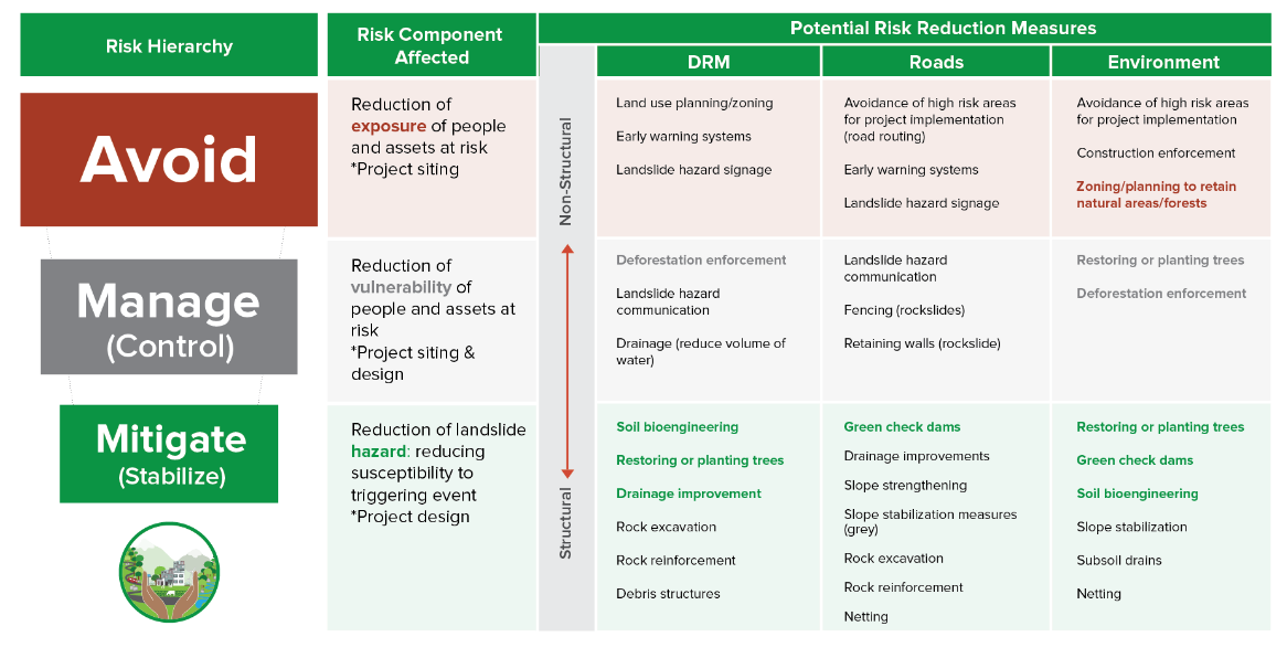
The choice of which landslide risk reduction methods to use will be influenced by the landslide hazard assessment (e.g. low/medium/high landslide hazard), relative cost-effectiveness of the options, and the exposure and vulnerability of elements at risk (i.e. what is the need/demand for risk reduction).
Selecting Mitigation Measures
An online tool has been developed by the KLIMA 5050 project (LaRiMiT: Landslide Risk Mitigation Toolbox) that helps users to select among many structural and non-structural landslide risk mitigation measures through algorithms that match landslide inputs to the characteristics of the measures, including technical feasibility and cost-effectiveness. The tool allows the user to input landslide and site-specific data and to assign weights to different constraints (e.g. environmental, economic, time). The tool processes the input data through algorithms that are based on expert scoring of measures and provides a list of mitigation measures that would be technically feasible and efficient for risk reduction.
Design considerations for selecting among mitigation measures include:
- Effectiveness in reducing risk to acceptable levels is a key consideration in using NBS. For high-risk areas, the team may consider implementing engineered grey solutions to improve the factor of safety calculation at a particular hillslope, and then plants trees and/or vegetation in the area immediately above the hillslope, or in the surround landscape, depending on topography and rainfall patterns. NBS on its own is often not enough to reach acceptable levels of safety, and current research in this space is focused on the contexts in which NBS can be appropriate and effective. Shallow landslides have been identified as one application area.
- Shallow, slow-moving landslides are often the best candidates for NBS. Grey engineering methods will be required for deep landslides, but NBS solutions can be added in a hybrid configuration to add resilience to the system as a whole.
- The use of NBS for landslide risk reduction requires collaboration across several disciplines , e.g. soil scientists, hydrologists, botanists, engineering geologists, maintenance personnel, civil engineers, and landscape architects.
- The project team needs to understand the overall site, climate, socio-economic, geo-engineering, scientific, risk escalating factors , in order to understand the socio-economic conditions, level of risk and the nature of failure mechanism before mitigation measure implementation.
- The project team needs to evaluate the ability for plants to grow, such as soil thickness, slope, type of landslide (slow and fast), and depth of failure plane in order to select appropriate species.
- NBS cannot replace all the functions of a geo-engineering/gray method since plant root depth goes down several feet.
- While NBS has been used for slope stabilization and protection in many areas, the applications are not directly replicable in other locations due to the site-specific nature of NBS.
- Selection criteria for plants and vegetation for NBS has been limited. The World Bank has closed this gap with a recent guidance containing plant selection criteria for NBS for landslide risk reduction.Sri Lanka NBS for Landslide Risk Management (World Bank 2019).
Additional Resources
Specific Selection Criteria for NBS and Hybrid Solutions
A recent Bank project on Forest-Based Landslide Risk Management in Sri Lanka developed a helpful selection criteria to short list sites for NBS and hybrid landslide risk reduction solutions. Criteria are shown in the Table below and are assigned different weights based on their conduciveness to NBS and hybrid solutions for NBS. Weights were developed based on experience and expert judgement. Each of the criteria below is divided into further categories and scored based on the conduciveness of the criteria’s to NBS and/or hybrid solutions. These criteria and categories are useful in understanding the relative contribution of various social, economic and environmental aspects in selecting sites that are appropriate for NBS and/or hybrid solutions.

Scores for Criteria Elements
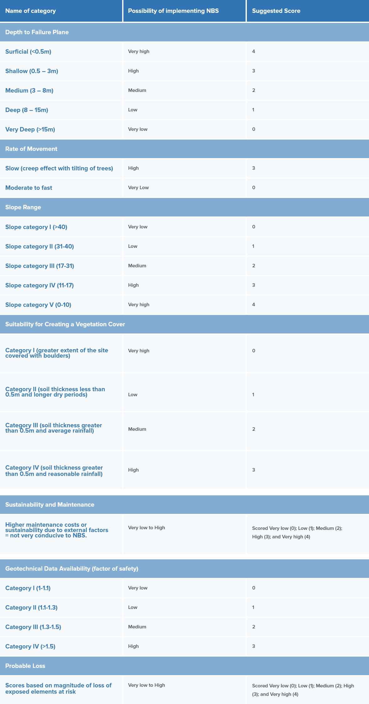
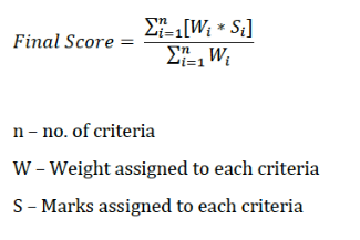
For each site, the final score is calculated as according to the following equation:
The Sri Lanka report also includes an extensive plant selection methodology using a multi-criteria framework. The five main criteria considered for plant species were: (1) plant type and structural characteristics; (2) hydrological significance; (3) root strength characteristics; (4) ecological significance); and (5) economic value. A comparative assessment of different vegetative techniques is also provided through the activity, including advantages and disadvantages of different planting techniques.
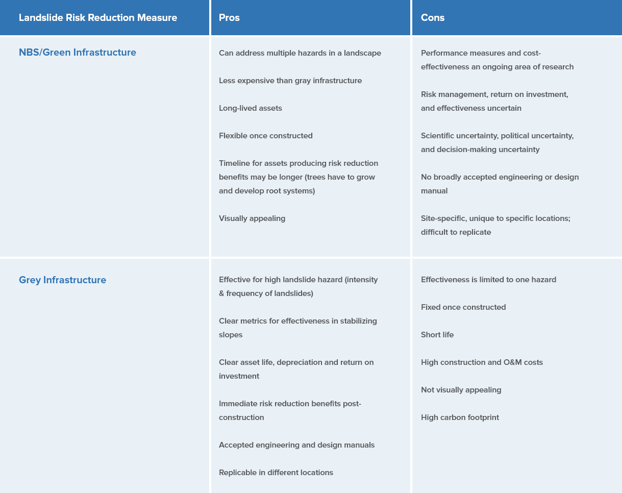
Comparison of NBS/Green Infrastructure and Gray Infrastructure
The table below summarizes some of the pros and cons of NBS/green vs. gray infrastructure, for those areas in which NBS or hybrid solutions have been assessed as feasible (see Question 2 in this section).
NBS Literature
1. Forbes et al, Forests and Landslides: The Role of Trees and Forests in the Prevention of Landslides and Rehabilitation of Landslide-Affected Areas in Asia, 2011
2. F. Preti, Forest protection and protection forest: tree root degradation over hydrological shallow landslides triggering, 2013
3. Rickli et al, Shallow Landslides: Retrospective Analysis of the Protective Effects of Forest and Conclusions for Prediction , 2019