Afghanistan Geohazard Roads Decision Support System [Roads/Subnational Project Level]
Introduction
Landslides are a significant threat to transportation infrastructure, especially in hilly or mountainous areas with steep slopes. Landslides can have adverse impacts on transportation infrastructure by injuring and killing people using the transport corridor, such as a road; cutting of connectivity where roads are blocked by landslide material, and damaging the infrastructure itself, leading to additional costs of repair. Development of transportation infrastructure can also impact landslides if appropriate risk reduction methods are not applied in the design, planning and construction phases. Risk reduction methods to avoid, manage and/ or mitigate landslide impacts to transportation infrastructure therefore have multiple potential benefits through saving lives, maintaining connectivity, and avoiding costs of repair and rebuilding.
The Afghanistan Geohazard Roads DSS product uses a landscape-scale assessment to determine landslide risks and risk reduction options. The Afghanistan Geohazard Roads DSS is a knowledge product of the Bank’s focused program on Building Resilience to Landslides and Geohazard Risk in the South Asia Region, and has been developed in conjunction with the Bank’s Trans- Hindukush Road Connectivity Project. More information on geohazard in transportation work at the Bank is discussed here. This case study describes a landslide risk assessment and decision support system for mitigation options implemented for the transport sector. Landslide and geohazard risks have typically been assessed at the local scale during planning and design of transportation projects and have been limited to the right of way of the road and to the direct impacts of road construction practices.
The Afghanistan Geohazard Roads DSS activity, a part of takes a broader view – looking beyond the right of way to the surrounding landscape, which can show landslide risk outside of the project area, but which may impact the project area. This project focused specifically on the Baghlan to Bamiyan (B2B) Road and the Salang Highway, two transportation corridors that are both economically important to Northeastern Afghanistan and Kabul and that are particularly susceptible to landslides and other geohazards. Michigan Technological University and the Michigan Tech Research Institute developed the DSS. The project included dynamic risk analysis and investment prioritization within the Bank’s Trans-Hindukush Road Connectivity project in Afghanistan in order to support transportation officials in the country to indentify geohazards along this important transportation corridor, and to gauge the effectiveness of investments to reduce identified risks.
Relevant Links:
Afghanistan Transportation Geohazard Risk Management DSSUser Manual for the Afghanistan Transportation Geohazard Risk Management DSS
Tutorial Video: Afghanistan Transportation Geohazard Risk Management DSS
Afghanistan Multi-Hazard Risk Assessment
Data and Methodology
The landslide hazard assessment informing the DSS was developed using the factor-of-safety approach as detailed in Section X of this guidance tool. The first phase of the project was focused on identifying the high hazard areas, the variables that impact the hazard, and mitigation measures that may reduce the hazard. The study team determined that the primary landslide triggers in the project area were precipitation and seismic-induced and that slopes in the study area were susceptible primarily to shallow translation landslides and deep rotational landslides. Input data used included topography (DEMs) to derive soil inclination values, soil and rock properties, and rainfall and earthquake data. Soil strength data was obtained from the study team’s counterparts in Afghanistan from sampling locations along the B2B road.
Different models were used to develop the factor-of-safety estimates for each trigger and type of landslide. The study used the TRIGRS model (USGS) for rainfall and snowmelt induced landslides, a factor-of-safety model used for shallow rainfall-induced landslides. Inputs to the factor-of-safety estimation for rainfall- induced landslides were soil cohesion, friction angle, water table depth, hydraulic conductivity, and hydraulic diffusivity. The study used two models for seismic triggered landslides: the infinite slope model coupled with a Newmark seismic displacement model for shallow slopes, and the SCOOPS3D model (USGS) for deep seismic landslides. The study assessed both the source and propagation processes for these potential landslides. Propagation of landslides was assessed using the height to runout ratio approach, which assesses how far a landslide will travel from its source location based on elevation changes along its path.
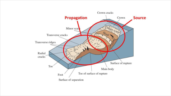
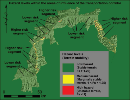
Figure 6: Large-scale hazard map for the Afghanistan study area
Results
The landslide risk and risk reduction assessment results in a DSS tool that allows transportation officials and other stakeholders to visualize landscape-scale geohazard risk impacting the Baghlan to Bamiyan (B2B) Road and the Salang Highway, and to assess cost-effectiveness of mitigation measures that can inform the development of risk reduction investment plans. Hazard scenarios developed allow the user to select the geohazard of interest (avalanche or landslide); the trigger (seismic, rainfall, or combined); the landslide model (shallow or deep); the return period; source or propoagation; and the mitigation measure.
Mitigation measures included in the DSS are slope modification; soil strength increase through mitigation measures such as shortcrete; and groundwater table reductions. Input parameters of the model were modified to reflect the impact of various mitigation methods. For example, the value of cohesion in the models was modified to reflect increased soil strength from slope stabilization methods such as small retaining structures and erosion control.
Per unit cost estimates for mitigation measures specific to Afghanistan are also included in the DSS, and were developed during a 2017 workshop in Dubai. The user can assess the change in hazard level when different mitigation measures are selected for each hazard scenario, and can compare the cost-effectiveness of various mitigation options. These features align the DSS with regular transportation decision making processes and project cycles (feasibility and design, construction, operations and maintenance) in Afghanistan. The DSS is also aligned with the Afghanistan GeoNode database of spatial datasets created by the World Bank.
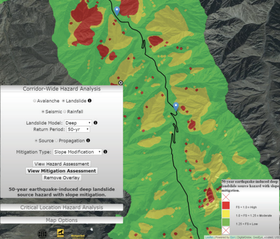
Sample DSS output for slope modification on a 50-year deep seismic-induced hazard assessment
The DSS could potentially assist in decision-making at various stages of the project cycle. The landscape-level hazard maps generated through the study can be used in the planning stage when decisions around road routing or road widening are made. High hazard areas at the landscape level can be avoided, and the road routing instead developed along a lower hazard pathway. In the feasibility stage, the DSS can help project managers understand the level of hazard present and to design mitigation measures (through the understanding of cost-effectiveness that the DSS provides) along potential routes that can help with final road alignment since the decision will involve multiple considerations in addition to hazard. However, the utility of the DSS would rely heavily on the reliability of the generated hazard maps. High spatial resolution topographic data and field validated geologic datasets are critical for developing reliable hazard maps.
Nature-Based Solutions
The DSS provides a generic tool to evaluate the utility of NBS for stabilizing the slopes by utilizing the increase in root cohesion that can be achieved. Chok et al. (2015) provide details of expected root cohesion that can be achieved using different vegetation. The cohesion values could vary from 1 to 95 kPa depending on the type of vegetation and its maturity level. The DSS allows the user to utilize this root cohesion input and evaluate at a landscape level how much of the hazard could be mitigated from different NBS solutions.
Additional Resources
Hearn 2011 is a compendium of slope engineering techniques for mountain roads that describes slope stability and erosion protection mechanisms for rights-of-way and for slopes that are outside of the right-of-way.