Landslide Risk Assessment
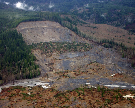
Image: PS point detail, Bhutan
What is landslide risk?
Landslide risk is defined as “a measure of the probability and severity of an adverse effect to health, property or the environment [as a result of landslides]” (Corominas et al., 2014). Landslide risk assessment allows policy makers, practitioners and the development community to understand the probability, severity and spatial location of risk in order to prioritize risk reduction measures to avoid, manage and mitigate the risk.
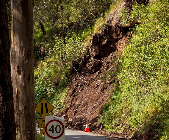
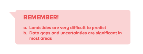
Landslide risk assessment is multifaceted and complicated. Due to the complexity of landslide and triggering processes, and data limitations and uncertainties in certain areas, landslide risk assessment is necessarily multifaceted, incorporating a wide variety of potential modeling methodologies and data sources. A recent paper notes the disparity between data and information available for natural disasters such as earthquakes (see the Global Seismic Network; the International Seismological Centre; and the USGS National Earthquake Information Center) or cyclones (see the NOAA Geostationary Satellite Server ), which have global infrastructure for in-situ and satellite monitoring such as these that provide real-time data, and that available for landslides, for which there are limited such systems. A challenge to in-situ or satellite monitoring of landslide occurrences is related to the multiple dimensions of landslides: landslide movement differs (e.g. falls, topples, slides, spreads and flows) and sizes can vary significantly from a few meters to many kilometers in length; events take place in a wide variety of environmental contexts (e.g. land use, soil characteristics, climate) and have different triggering factors (e.g. rainfall, earthquakes, human activity). Further, rainfall, which is the most common trigger, varies spatially and seasonally, so identifying threshold values above which slopes are likely to fail is challenging. Determining when and how a landslide may occur, therefore, is complicated, and further complicated by the degree of lack of data for any of the environmental or causal factors.
Risk: Important Concepts
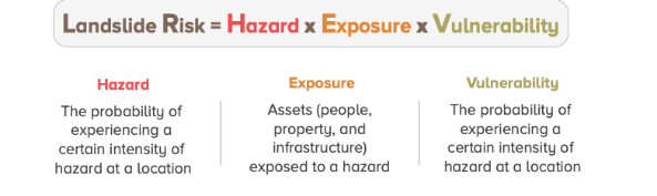
Disasters are comprised of three primary elements: (1) the hazard , e.g. the earthquake, extreme precipitation; (2) the exposure of people, property and infrastructure to the hazard; and (3) the vulnerability of exposed people and assets to the hazard event, in other words, the resulting impact of the hazard on exposed people and assets. (World Bank 2012)
A measure of the probability of damage to life, health, property, money, or the environment. Risk is defined as the probability of the natural hazard event multiplied by the damage from possible consequences. Managing risk requires risk assessment.
Risk assessment involves an estimation of the probable impacts (economic, social, environmental) arising from particular or multiple hazards.
- Hazard: the probability of experiencing a certain intensity of hazard at a location
- Exposure: assets (people, property, and infrastructure) exposed to a hazard
- Vulnerability: the susceptibility of the exposed assets to damage from the hazard event
A disaster is the hazard’s effect on society as a result of the combination of exposure and vulnerability. Disasters, not hazards, cause deaths and damage.
Calculated as a multiplicative function of hazard, exposure and vulnerability because disaster risk exists when hazard, exposure, and vulnerability are all present.
GFDRR 2014 Understanding Risk Guidance
GFDRR 2010 Natural Hazards, UnNatural Disasters
How do we assess landslide risk?
Landslide risk assessment overlays the susceptibility of a slope to failure with triggering factors (e.g. rainfall), exposure (elements at risk), and vulnerability (of the elements at risk) to develop risk estimates. Landslide risk assessments contain the following five elements: (1) Hazard Identification; (2) Hazard Assessment (susceptibility + triggering factors); (3) Inventory of elements at risk (exposure); (4) Vulnerability; and (5) Risk Estimation.
Hazard identification: characterizes the landslide risk using existing landslide inventories, literature and expert opinion.
Hazard assessment: selects susceptibility methodology and combines with trigger factors to determine landslide hazard in the study area.
Exposure: data is gathered on elements at risk in the study area (e.g. people, buildings, infrastructure).
Vulnerability: data is gathered (from expert opinion, literature, and/or physical models) on how vulnerable the elements at risk are to damage from a landslide event.
Landslide Risk Equation
Quantitatively, the risk of occurrence for a single landslide can be explained by the equation:
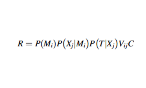
R = the risk due to the occurrence of a landslide of magnitude Mi on an element at risk located at a distance X from the landslide source
P(Mi) = the probability of occurrence of a landslide of magnitude Mi
P(Xj|Mi) = the probability of the landslide reaching a point located at a distance X from the landslide source with an intensity j
P(T|Xj) = the probability of the element being at the point X at the time of occurrence of the landslide
Vij = the vulnerability of the element to a landslide of magnitude i and intensity j
C = the value of the element at risk
Landslide risk assessment is conducted primarily in a geospatial environment. Geospatial modeling of landslides happens primarily in a raster environment, where the area of interest is represented as a set of cells, each of which has certain parameters assigned to it to assess hazard, exposure, and vulnerability. Outputs are typically landslide maps at varying resolutions that identify areas at higher risk from landslides. These spatially explicit outputs enable decision-makers and stakeholders to identify hotspots, and to layer other spatial layers of interest to produce additional analyses.
Landslide Risk Reduction
Landslide risk assessment informs risk reduction methods. Landslide risk assessment provides the spatial identification of different levels of landslide risk, and information on drivers of risk that enable selection of risk reduction methods. Landslide risk reduction measures can be non-structural or structural. Non-structural measures, also referred to as “consequence reducing measures” can help avoid risk through disaster risk preparedness and emergency management (e.g. early warning systems, escape routes, evacuations). Structural measures seek to stabilize and protect susceptible slopes (reducing the driving forces or increasing the resisting forces) through built infrastructure, including barriers such as ramparts, walls, anchoring and retaining structures (gray infrastructure) and vegetation and ground improvement (nature-based solutions/green infrastructure) that can improve drainage and soil stability and protect against erosion and soil instability.
Landslide risk reduction measures are facilitated through information, institutions and investments. Landslide risk assessment and subsequent monitoring provide information on hazard hotspots and people and assets at risk, and on variable environmental conditions that impact landslide hazard, which allows governments and communities to avoid high-risk areas by informing land use planning and zoning and project siting. Institutions are critical to hazard communication and facilitating landslide risk avoidance strategies, as well as to development and funding landslide risk assessment studies. Investments for landslide risk reduction include disaster preparedness and early warning systems, engineering (grey infrastructure) solutions, and nature-based solutions (green infrastructure).
Video: Landslide Hazard and Risk Assessment, UNISDR
Corominas et al (2014), Recommendations for the quantitative analysis of landslide risk
Landslide Hazard Mitigation Measures
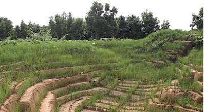
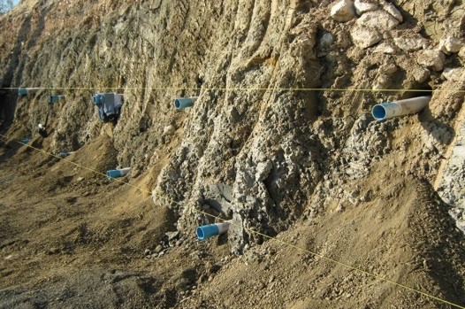
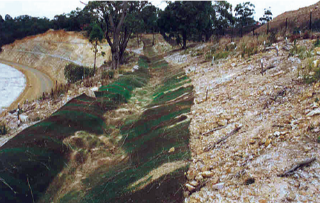
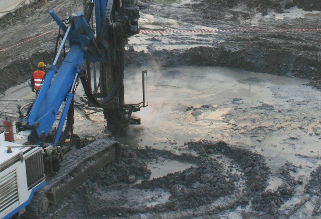
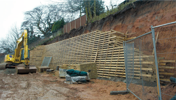
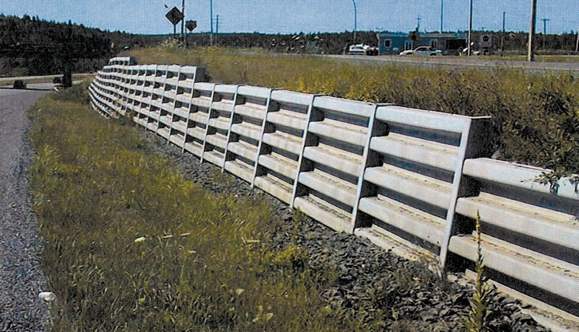
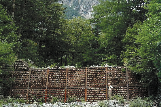
The table below summarizes landslide hazard mitigation measures for landslide risk reduction. Measures are categorized in the groups established by the International Union of Geological Sciences Working Group on Landslides (IUGS WG/L) : modification of slope geometry; drainage; retaining structures and internal slope reinforcement. Primary NBS measures relevant to landslides include forests, vegetation, geotextiles/geosynthetics, and soil mass movement. The planting or protection of forests and vegetation to reduce landslide risk, also known as bioengineering, reinforce the soil by “acting like nails into the slopes” and in decreasing water content through evaporation. (KLIMA 5050) Nature-based solutions for various physical processes are denoted in green text. Mitigation measures are summarized in this section; a later section of this guidance tool provides detail on how various mitigation measures may be assessed to solve a particular landslide risk problem. A catalog of landslide mitigation measures arranged by physical proces is available from the LaRiMiT (Landslide Risk Mitigation Toolbox) tool.
| Physical Process | Description | Photo Gallery |
|---|---|---|
| Surface protection & control of surface erosion |
|
|
| Modifying surface water regime – surface drainage |
|
|
| Modifying groundwater regime – deep drainage |
|
|
| Modifying mechanical characteristics of the unstable mass |
|
|
| Transfer of loads to more competent strata |
|

Additional Resources
Satellite Remote Sensing for Landslide Hazard Assessment
While individual landslide events are highly local, government agencies tasked with risk identification and management have to take a broader view of landslide susceptibility at the landscape scale. However, identifying historic and potential future landslide location is complicated by the lack of ground-based sensors at landslide sites that could provide useful information on mass movements and triggers such as rainfall. In-situ monitoring, especially at the larger scales that would be required for large infrastructure projects and in mountainous areas, is expensive. Remote sensing offers a more cost-effective way to assess landslide hazard at the landscape scale, facilitating landslide risk assessment, monitoring, and management across multiple sectors. Emerging technology such as artificial intelligence and machine learning are also being applied in this space, to aid in landslide identification and hazard assessment. The Bank has facilitated the use of remote sensing for the transport sector in South Asia, where the need for geohazard analysis and visualization is critical for proactively managing aging infrastructure and potential impacts due to climate change and increases in precipitation. Satellite-based remote sensing offers a solution to these challenges through continuous observation using high spatial resolution and large coverage imaging systems, and frequent and consistent observations.
A recent Bank project explored the use of satellite-based interferometric synthetic aperture radar (InSAR), particularly persistent scatterer interferometry (PSI), for landslide monitoring in parts of India, Bhutan, and Nepal. Sentinel-1 satellite data of persistent scatterers (PS) were used to measure ground deformation in each study. The velocity obtained from the InSAR was combined with the slope for the hazard weighting with velocity being weighted as twice as important as the slope. The percentile of the slope and velocity was used to create three weight classes: > 90th was weighted the highest, followed by 50th–90th, and then < 50th. The hazard weighting was combined with an exposure rating, which considered the presence of houses and roads. The combination of hazard weighting and the exposure rating provided the total risk score that enables us to rank the clustered velocities for identifying priority sites. The priority sites identified as part of this project using PSI in Bhutan were utilized by the Japan International Cooperation Agency (JICA) to select sites for instrumentation to develop rainfall threshold-based early warning systems. The early warning system for the landslide is the first attempt in Bhutan and will be used to alert traffic before a landslide.
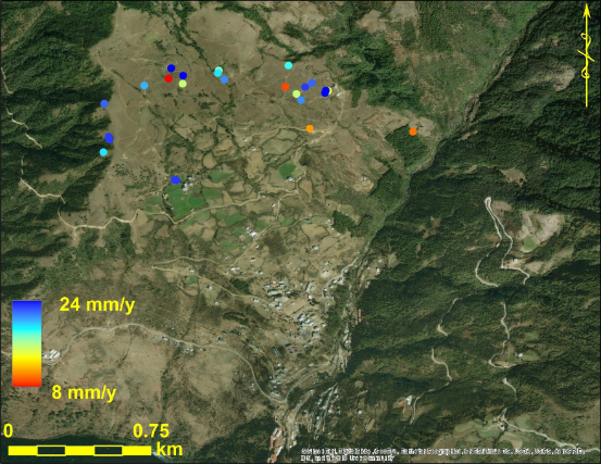
Image: PS point detail, Bhutan
Other satellite remote sensing-based resources available for landslide hazard assessment include:
Committee on Earth Observing Systems (CEOS) Disaster Working Group : leading landslide pilot to study satellite earth observation for disaster preparedness, response and recovery at local, regional and global scales.
Landslide Hazard Assessment for Situational Awareness (LHASA) : a global landslide model developed by NASA
Zhong et al, Landslide mapping with remote sensing: challenges and opportunities
Satellite‐Based Assessment of Rainfall‐Triggered Landslide Hazard for Situational Awareness
Types of Landslide Risk Maps
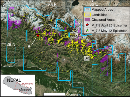
Source: (Roback et al 2018)
Landslide inventory maps show the size and location of landslides that have occurred in a given area. These maps are helpful in understanding where future landslides may occur, given that certain variables impacting slope stability may still be present.
The landslide inventory map in Nepal below (Roback et al 2018), and the U.S. Landslide Inventory Web Application are useful depictions of this type of map.
Source: NASA
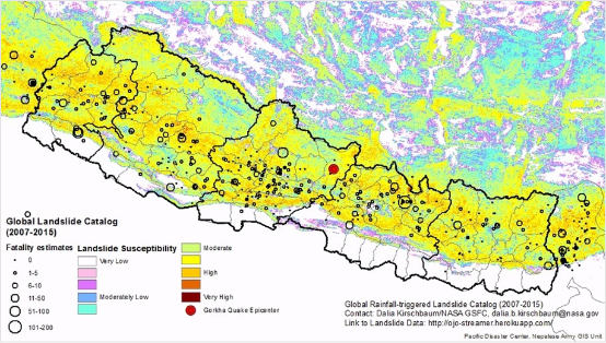
Landslide susceptibility maps show the susceptibility of a particular study area to future landslide occurrences. Susceptibility can be determined using a variety of methods as described in Section X of this guidance tool. For example, local physical conditions (topography, slope steepness, soil strength) can make certain areas more susceptible to landslides than other. A landslide susceptibility map for Nepal from NASA is shown below. NASA also has produced a global view of landslide susceptibility map, showing landslide potential around the world; a close-up from India/Nepal is also shown below.

Source: NASA
Two additional examples of large-scale susceptibility mapping and visualization are the California Deep Landslide Susceptibility and Landslide Inventory Map, and the Colorado Springs Landslide Susceptibility Map.
California Deep Landslide Susceptibility and Landslide Inventory Map
Colorado Springs Landslide Susceptibility Map
Landslide hazard maps show the probability that a landslide will occur in a given study area and may also provide information on the downslope flow of the landslide, to show where overlap with elements at risk (people, buildings, and infrastructure) may be. The image below shows a landslide hazard map created by the Yale Himalaya Initiative .
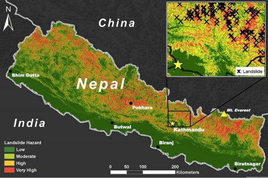
Source: Roback et al 2018
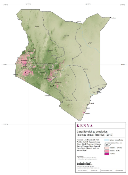
Source: GFDRR National-Level Landslide Risk Profiles for Sub-Saharan Africa, 2018
Landslide risk maps show risk and loss estimates when landslide hazard is overlaid with elements at risk (exposure) and vulnerability. Risk maps can show risk to elements at risk (people and infrastructure), as well as risk to GDP. Estimates can be given for the current period, as well as for projections in the future.
Landslide Monitoring and EWS
There are examples of landslide monitoring systems at various geographic scales. While landslide risk assessment is complex, monitoring of landslides does occur, such as with in-situ monitoring of a single hillslope, and monitoring systems at the city or national level that use in-situ rainfall monitoring devices. At a local level, the USGS has a number of site-specific monitoring activities for high risk areas. At the city level, Rio de Janeiro in Brazil has a system called Alerta Rio that combines rainfall data from gauges across the city with a landslide susceptibility layer to identify potential slip areas. At the national level, examples include Norway, which has a national landslide early-warning system run by the Norwegian Water Resources and Energy Directorate that monitors triggering factors for landslides.
Another example is Japan’s Meteorological Agency, which has a real-time landslide risk map as well, allowing the user to zoom to a desired location and view landslide risk. (Kirschbaum and Stanley 2018) Recently, NASA released its LHASA platform (Landslide Hazard Assessment for Situational Awareness) that can assess and provide “nowcasts” of rainfall-triggered landslide potential from regional to global scales using publicly available remotely sensed and other data. Landslide potential in the LHASA system is defined as the “times and places where landslides are more probably relative to other locations”. (Kirschbaum and Stanley 2018) These monitoring solutions all rely on landslide risk assessment methodologies for data on landslide hazard, exposure, and vulnerability.
Literature
Corominas et al (2014), Recommendations for the quantitative analysis of landslide risk.