Landslides 101
Tools and approaches for controlling landslides must consider their underlying complexity. The multiple potential causes of landslides mean that landslides are complicated and difficult to predict, but also that a myriad of approaches to understanding and reducing landslide risk exist. Landslide risk assessment, covered in the next section, generates spatial outputs that identify areas of relatively higher landslide risk, and the drivers of that risk. In some areas, for example, slope steepness may be the primary underlying factor increasing shear stress, while in other areas it may be soil water saturation from improper drainage. Once the primary drivers are known for those slopes prone to failure, mitigation measures can be designed to influence components of the factor- of-safety that can strengthen the shear strength of the soil. Risk reduction measures include nature-based solutions, traditional grey engineering structures, and broader information and communication measures. Landslide risk assessment allows for prioritization of which risk reduction measures are implemented in specific areas of risk.
What is a landslide?
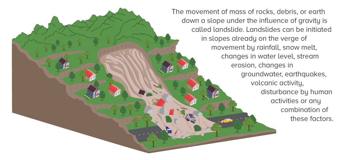
Landslides involve the movement of material down a slope due to a number of factors. Landslides can be defined as “the downslope movement of soil, rock, and organic materials under the effects of gravity and also the landform that results from such movement.” (USGS 2008) Debris flows and rock falls are typical types of landslides. Landslides can also be fast and shallow flows that result from short but high intensity rain events, or deep slides that result from average precipitation quantities. (Kirschbaum and Stanley 2018) Landslides occur quickly, often without warning, and are difficult to predict.
What types of landslides exist?
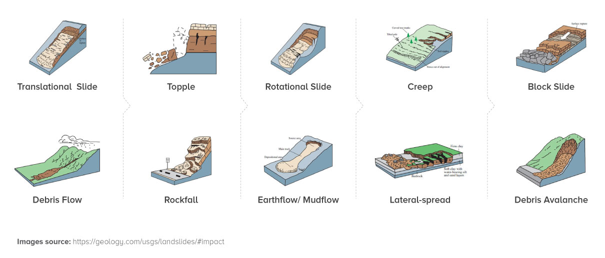
Many types of landslides exist, based primarily on the type of material and the type of movement exhibited. Landslides are primarily classified according to the type of movement, the type of material, and the velocity of movement. In its Landslide Types and Processes fact sheet (2004), the USGS provides a straightforward and simplified treatment of landslide movement and material types. They discuss five types of slope movement: falls, topples, slides, spreads and flows, which can be further divided by the type of geologic material (bedrock, debris, or earth) that is moving. The full typology of landslide types can be much more complicated. For example, the Varnes classification of landslides (1978, also consulted for the USGS fact sheet) is a well-known typology, which was recently updated (2014) to incorporate changes in materials and movement characterization, and recent developments in landslide science. The updated Varnes classification (Hungr et al 2014) now includes 32 landslide types, and also includes a classification system for the velocity of landslide movement.
What are the factors that cause landslides?
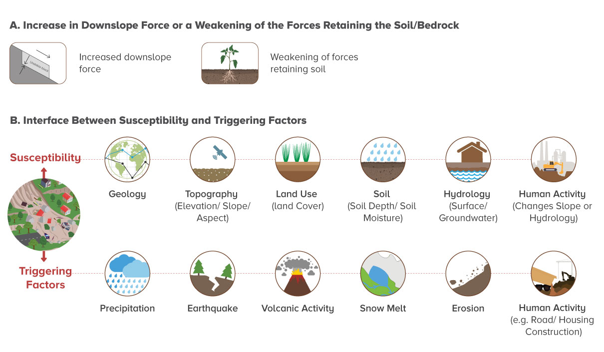
Landslides occur where the forces retaining soil and the fractured bedrock are exceeded by the downslope force. Slope stability depends on factors such as material properties (cohesion and internal friction); slope angle; weight distribution; water content; and vegetation. Landslides are caused when either the downslope force is increased, or the forces retaining the soil/bedrock are weakened by a forcing/triggering event. Factors acting on these forces to cause landslides (triggering events) most commonly involve precipitation and earthquakes, though snowmelt, erosion, volcanic activity, and groundwater changes are some other factors. (USGS 2008) Rainfall has been noted as the most frequent cause of landslide events. (Petley et al 2005)
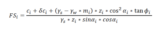
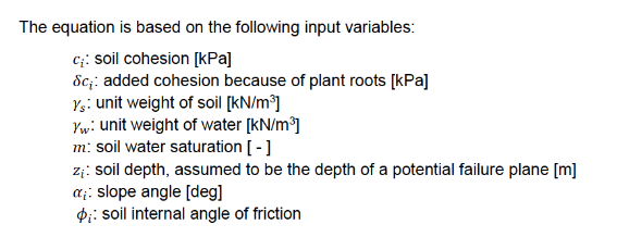
The factor of safety represents the stability of a slope as the ratio of shear strength to shear stress. A factor of safety less than one indicates a slope prone to failure; a factor greater than one indicates a stable slope. Landslide triggers decrease the factor of safety to less than one, causing a landslide. There are different ways to calculate the factor of safety. One more detailed representation of the factor of safety (FS) is below, showing how various physical features of a slope can impact its factor of safety value. It is important to note that added cohesion from plants roots is a component of the shear stress calculation.
The components of slope stability can be impacted by numerous factors. Landslides result from an increase in downslope force and/or a weakening of the forces retaining the soil/bedrock, as indicated in the factor-of-safety equation. The landslide hazard in a given location (e.g. the factor-of-safety number for that location) is determined by the interface between the underlying susceptibility of a hillslope to mass movement and triggering factors that may present, because susceptibility and triggering factors impact the different components of the factor-of-safety value.
The susceptibility and triggering factors are impacted both by natural conditions and processes, and by human activity. For example, underlying susceptibility of a hillslope may in part be determined by the slope angle, soil and water characteristics, but human activity can influence these environmental variables (e.g. land use change around a hillslope may impact soil moisture). Triggering factors can also be “natural” in the sense that some amount of precipitation may reflect a long-term average, but human-induced where climate change increases the variability and intensity of precipitation events. Human activity such as road and housing construction can also act as a triggering factor where construction practices destabilize slopes enough to cause them to fail. Housing in landslide-prone areas increases the exposure of people to the risk. Finally, deforestation is another important factor in increasing underlying susceptibility, due to the decrease in soil cohesion once roots are removed.
What are the impacts of landslides?
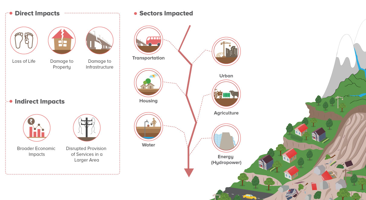
Landslides have myriad impacts. Landslides can cause significant damage to elements at risk that are exposed to landslide risk, depending on the vulnerability of these elements at risk to damage. Potential elements at risk include people, livestock, buildings, and infrastructure across many sectors, such as transportation, housing and urban development, agriculture, water and energy. Direct impacts include injury and loss of life to people and damage to property and infrastructure, all of which can have significant and adverse impacts to livelihoods. Indirect impacts of landslides include broader economic impacts resulting from disruptions in connectivity or provision of services in a larger area that occur after a landslide event. Further, landslide events may become more frequent with climate change given increases in precipitation and extreme precipitation events, which work to decrease soil strength through increased flooding, ground saturation, and runoff.
Additional Resources
The World Bank’s Landslide Activities
The Bank has been involved in projects that both address landslide-related impacts after disasters have occurred, and also increasingly proactive measures to both reduce landslide risk and reduce potential impacts in the event of landslide occurrence. This is in line with the Bank’s overall movement in disaster work from disaster response to disaster risk management. (GFDRR 2016) A snapshot of Bank projects that include a landslide risk assessment component is available here. Landslide risk assessment projects have been supported by DRM, GFDRR, and ENB including the Building Resilience to Landslide and Geohazard Risk in the South Asia Region activity , National Landslide Risk Assessments for Africa; and the Kaligandaki Valuing Green Infrastructure Report. Other work includes the Resilient Infrastructure: Roads, Landslides and DRM activity. Activities have also included post-disaster needs assessments for Sri Lanka and Sierra Leone, and multiple investments through projects that address landslide risk, such as the Climate Related Hazards Project and the Earthquake Housing Reconstruction Project in Nepal.
Deep Dive: The Bank’s Landslide Risk Management in the Transport Sector Program
The Bank has a focused TA program on Building Resilience to Landslides and Geohazard Risk in the South Asia Region. This is a Global Facility of Disaster Risk Reduction (GFDRR) program funded by the European Union (EU). The Community of Practice for this work is located here. The geohazard program is to build the capacity of policymakers and practitioners of governmental counterparts in South Asia to integrate geohazard risk management into policies and practices to ensure the safety of lives and sustainability of investments, especially in the road sector.
The need for geohazard risk management in South Asia, and particularly in the Hindu-Kush and Himalayan mountains, is very high due to high seismic activity, higher-intensity and higher-frequency rainfalls during the monsoon due to climate change, and more human intervention in high geohazard risk areas such as for road construction or expansion and new community or agricultural developments. This human activity on high-risk slopes can increase erosion, sedimentation, and landslide risk. Landslides' economic and human impacts can be massive, especially in areas that are difficult to access due to the extended closure of access roads.
A number of knowledge products and knowledge exchange components have been completed under the South Asia program. A recent blog post about the program provides detail on activities completed so far. The program includes a South-South learning exchange component, with recent events in Sri Lanka, Nepal, and New Zealand focused on capacity building for geohazard risk management. These learning exchanges are broad in content and bring together engineers from transportation and infrastructure departments in various countries. Key takeaways from the workshops for building geohazard resilience included spatial risk quantification through risk assessment, risk-informed planning, and impact-based early warning. The capacity-building workshops helped inform the case study presented in this guidance tool on integrating risk assessment to the Salang Pass road in Afghanistan through the Bank's Trans-Hindukush Road Connectivity Project. A decision support system (DSS) was developed through the project. The DSS uses risk assessment and cost-benefit analysis to prioritize different potential interventions to manage risk.
One of the program’s capacity building events included an engineers' training on slope assessment, investigation, and design measures in November 2019 in Kathmandu, Nepal. The training program leveraged the slope protection and road upgrading experience of participants and focused on: (i) capacity building for government engineers and practitioners working in road sector slope management activities from Nepal and Bhutan; (ii) networking and collaboration for engineers and practitioners in the road sector in Nepal and Bhutan; and (iii) development of training modules on slope management.
The DRM hub in Tokyo has also produced the "Road Geohazard Management Handbook" to capture key practices and techniques used in Japan and globally – ranging from specific engineering designs to institutional options. This handbook focuses on geohazard events with high probability but low impact magnitudes. In other words, relatively common storm events that could be mitigated through engineering solutions or route realignments. The handbook is an overall guidebook for the institutional context of road geohazard risk management, of which risk assessment is a part. The DRM hub in Tokyo also supported the International Symposium on "Tackling the Challenge of Slope Stabilization & Landslide Prevention" in Dehradun, Uttarakhand, India, in 2015. The symposium organized experts, policymakers, and practitioners gathered from around the world to share their knowledge and experience in landslide mitigation, prevention, and stabilization. Participants also considered and proposed new solutions for slope stabilization in Uttarakhand. The symposium included a session on "Landslide Risk Assessment and Early Warning System." During the workshop, methods discussed focused primarily on sub-watershed slope stabilization on landslide-prone slopes and slopes surrounding infrastructure projects. Topics relevant to landslide stability analysis were presented, including satellite data usage for landslide risk assessment, establishing rainfall thresholds for landslide risk assessment specific to Uttarakhand, and landslide mitigation methods. Additional information on this symposium is available here.
Relevant Literature
USGS Landslide Types and Processes
NASA Lands lide Disasters Page
Chowdary et al 2010, Geotechnical Slope Analysis
Hungr et al 2014, The Varnes classification of landslide types, an update