
In Phase 1, the background and knowledge base creation are generic for the hazard, exposure and vulnerability elements of the risk assessment. Existing data and data limitations are identified in order to help determine the level of landslide risk assessment that is possible.
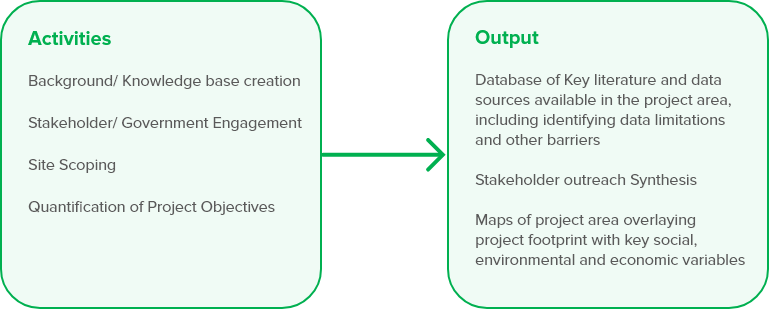
In the first phase, the parameters of the landslide risk reduction activity are established. These parameters include defining the problem and objectives, and the activity’s scope, budget, and timeline. Primary activities in this phase include background/knowledge base creation through literature review and stakeholder and government engagements. This background work helps to quantify project objectives, align these objectives with budget and timeline, and assemble the project team, including external consultants with domain expertise on LRA if necessary. These project parameters will inform the team’s selection of the LRA level, which can range from lower-cost rapid screening-level assessments to more costly and timeconsuming landslide risk assessments with cost-benefit analyses.
Phase 1 Activities & Output
Key questions answered in this phase
- Why is an LRA necessary for the project?
- What are the types of landslides expected in the project area?
- What key sectors are likely to be impacted by landslides in the project area?
- What data are available to perform an LRA?
In order to answer these questions, in Phase 1 the team should:
- Clarify the problem the project is aiming to solve. Clearly identifying the problem the project aims to solve will inform the end-use information requirement of the LRA. Engagement with relevant government agencies is critical to understanding the risks and determining how risk assessment and NBS may help client countries meet disaster risk reduction goals. If an LRA is deemed necessary, the end-use requirement should be spelled our clearly. The end-use requirement will inform the modeling approach and should happen concurrently with the data scoping exercise. The project team must understand whether the available data can meet the end-use information requirement, and if not, whether additional data or substitute/proxy data can be procured within the timeline and budget of the project to conduct a detailed LRA. If not, the project team must determine whether a screening-level, less sophisticated assessment using global datasets may be appropriate. It is also useful to consider whether resources spent on LRA could be optimized by also considering other disaster risks in the project area (e.g. flooding).
Example: Kaligandaki LRA
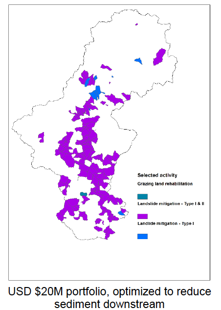
Watershed-level intervention prioritization to reduce downstream sediment Source: World Bank, Valuing Green Infrastructure Kaligandaki Report
The Kaligandaki LRA was developed through a larger project on green infrastructure for sediment management in the Kaligandaki Basin, Nepal, by ENB SAR in partnership with Stanford’s Natural Capital Project. The catchment- scale sediment assessment showed that landslides in the catchment were a key driver of sediment generation in waterways. For this reason, the project team decided to conduct an LRA to identify solutions to the problem of excessive sediment generation from landslides, which could help solve the problem of overall sediment load and offer benefits to agriculture, water supply, and hydropower production in the catchment. Data availability allowed for a detailed LRA with a cost-benefit analysis of NBS measures. Results allowed for prioritization of areas for NBS investment, which was the end-use requirement of the study.
An e-book developed for the Kaligandaki sediment activity is available here. An interactive tool to assess impacts of different watershed management practices on sediment generation in the watershed is available here.
- Define and quantify project objectives. Project objectives may be broad, and include landslide risk reduction, improvements in community-based natural resource management, climate change adaptation and others. The team may develop very specific landslide risk reduction metrics to be achieved. These may center around a specific change in the factor of safety at a particular hillslope necessary to create stability, and overall reductions in lives lost, damage to buildings and infrastructure, and other social, environmental and economic objectives. One economic metric often included in LRAs is direct economic losses related to GDP.
- Define geographic boundaries and scale. The geographic boundaries of the project may include the direct project area but also the larger watershed or landscape in which project components may impact the larger area, or where human and natural activity in the wider landscape may impact the project. Here, the team should consider a catchment/landscape-level approach if NBS is a desired potential solution.
- Identify likely project stakeholders and beneficiaries. Project stakeholders and beneficiaries can be identified through key consultations that should occur in Phase I of the project. Stakeholder and expert consultations can identify potential direct and indirect impacts of landslide risk in the project area, can be sources of data and knowledge that the project team can leverage, can help to define the solution space, and can increase buy-in for potential solutions, especially those that include NBS.
Key Consultations for Landslide Risk Assessment
Managing landslide risk, like other types of natural and geohazard risk, interface with a variety of sectors and therefore stakeholder groups. Key stakeholder consultations for the team include:
*Bank teams with prior experience conducting LRA. This will include work under DRM, GFDRR, Water GP, and Transport, among others. *Landslide risk/disaster risk experts at academic institutions. *Firms specializing in landslide/geohazard risk assessment, especially those that have conducted this type of work for the Bank in the past. Teams from these firms may include engineers, hydrologists and other scientific specialists relevant to landslide assessment. Firms working on NBS may also have foresters and arborists on staff.
*Landslide risk/disaster risk experts at academic institutions.
*Firms specializing in landslide/geohazard risk assessment, especially those that have conducted this type of work for the Bank in the past. Teams from these firms may include engineers, hydrologists and other scientific specialists relevant to landslide assessment. Firms working on NBS may also have foresters and arborists on staff.
*Government agencies that oversee various aspects of landslide risk management and impacts, including Ministries managing environment, forests, geologic research, water/hydromet, and local authorities. For example, in Nepal, these agencies include:
- Department of Hydrology and Meteorology
- Department of Roads
- Department of Mines and Geology
- National Emergency Operation Center
- Natural Disaster Risk Reduction Management Authority
*Development partners/NGOs working in the project area.
*Community organizations and groups operating in the project area.
These consultations will help the team to develop a partner network for the project, and to leverage existing data and knowledge from these groups.
-
Identify existing data and data requirements. A more sophisticated LRA will require sub-national and perhaps site-specific data on soils, topography, elements at risk and other relevant variables. Landslide data sources include both in-situ and satellite sources. Data required for each step of the LRA process can come from on-the-ground data and expert opinion, as well as from remote sensing.
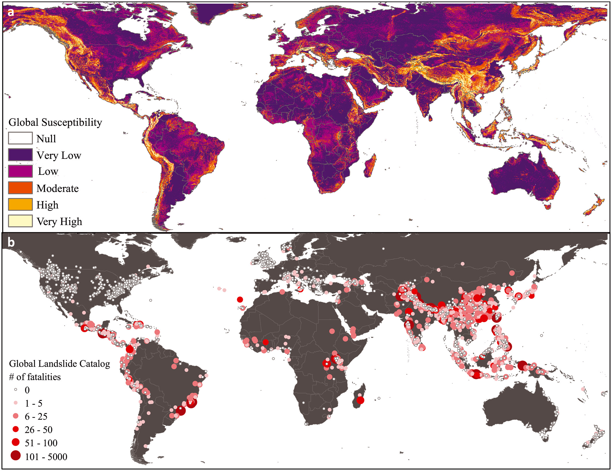
Global datasets are also available, some at high resolution for use in more localized areas. The project team must also review the catalog of feasible interventions and confirm that data will support the assessment of NBS along with other necessary interventions. Finally, where data are not readily available, the project team must determine whether resources are sufficient to obtain additional data, or whether appropriate proxy data are available.
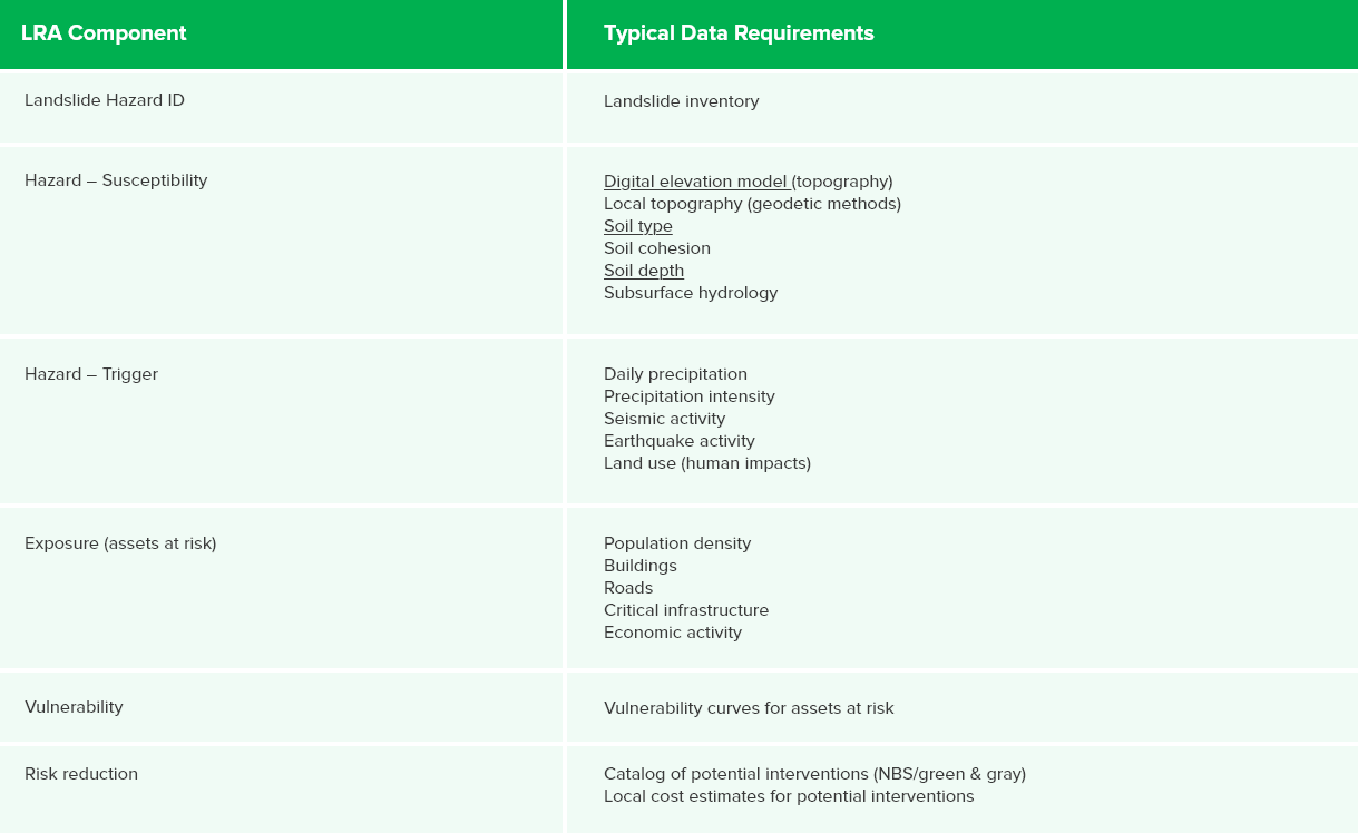
Typical Data Requirements for LRA
The table below highlights typical data requirements for implementing the different steps of a landslide risk assessment. Other data may supplement the examples listed below as available to the project team. Teams may depend on global, national, regional, or site-specific data as available based on project timeline and resources, and local data availability and/or capacity to collect and process additional data.
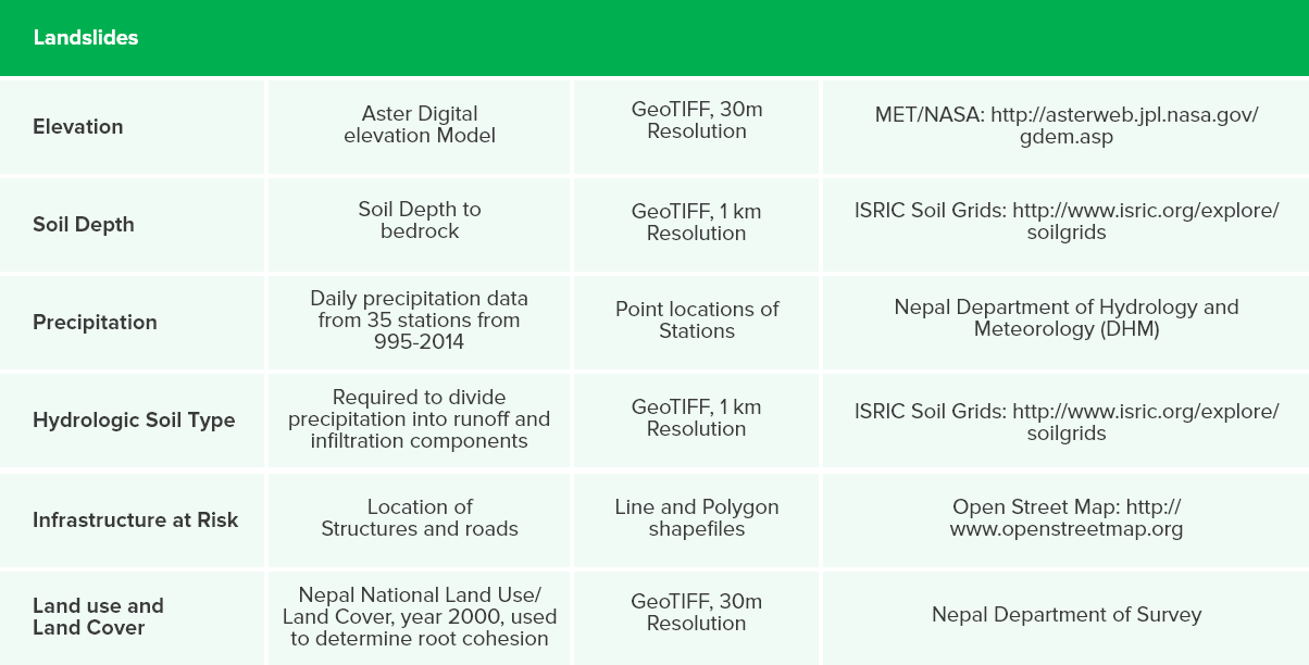
Data Example : Kaligandaki LRA
The table below shows the data used for the Kaligandaki LRA, the resolution of the data and the sources.
Select level of LRA possible given timeline and budget. The project parameters inform the project team’s selection of the level of LRA to conduct. The complexity and sophistication of the LRA level should align with the project timeline and budget identified during Phase I.
Develop the ToR for LRA. A ToR for an LRA will likely be necessary for LRA Levels 2-4, unless the team has a Bank staff member with domain expertise in LRA. The team should take care to include as much information in the ToR as possible in terms of the end-use requirement of the LRA, to ensure that the consultant delivers information at the scale and level that is useful for the team to solve the problem at hand.
Developing a Terms of Reference for LRA
As the team designs a Terms of Reference (ToR) for the level of landslide risk assessment desired, specific elements to include are
- Scope of project (problem, objectives, timeline, budget)
- Data and stakeholder inputs assembled
- Desired end use requirements for outputs
- Level of LRA modeling preferred
An example for a Terms of Reference is available from the Freetown, Makeni, and Bo city-level assessments conducted by GFDRR and detailed in Section X of this guidance tool. There, the report notes the following scope of the project within the ToR:
- A review and assimilation of relevant and up to date hazard, exposure, vulnerability and risk information, current DRR initiatives at city level and current urban planning policy/guidance in Freetown, Bo and Makeni
- A qualitative review of the natural hazards and risks in the form of maps and tables;
- A preliminary action plan for DRM;
- Quantitative reviews of natural hazards and risks in the form of maps and tables (landslides, coastal erosion and sea-level rise in Freetown only);
- Final DRM suggestions;
- High-level cost benefit analysis for five DRM options;
- To lead the delivery of risk information to the ONS and the city councils in each of the study cities;
- To frame the results of the qualitative and quantitative risk assessments in the context of urban planning;
- Progress meetings with the World Bank and ONS; and
- To undertake three field visits to Sierra Leone to gather data for the project, liaise with stakeholders and lead the delivery of risk information to the key stakeholder as specified above. These field visits are referred to as Mission #1, Mission #2 and Mission #4.
The Bank has also released a Road Geohazard Risk Management Handbook that can provide information useful in developing a ToR. Appendix A.2 of the report provides a template for a ToR for Risk Evaluation and Risk Management Planning for the completion of a risk evaluation and associated risk management planning tasks for road geohazards. One potential deliverable is detailed hazard mapping of areas that roads pass through.
Also see Masa’s ToR example, and the LOI for Lao. See also ToR provided by Stuart (example of exemplary ToR)
Assemble and finalize project team. The project team for the LRA will likely include Bank staff both within and external to the project area’s region, government clients, and external consultants with domain expertise in LRA.
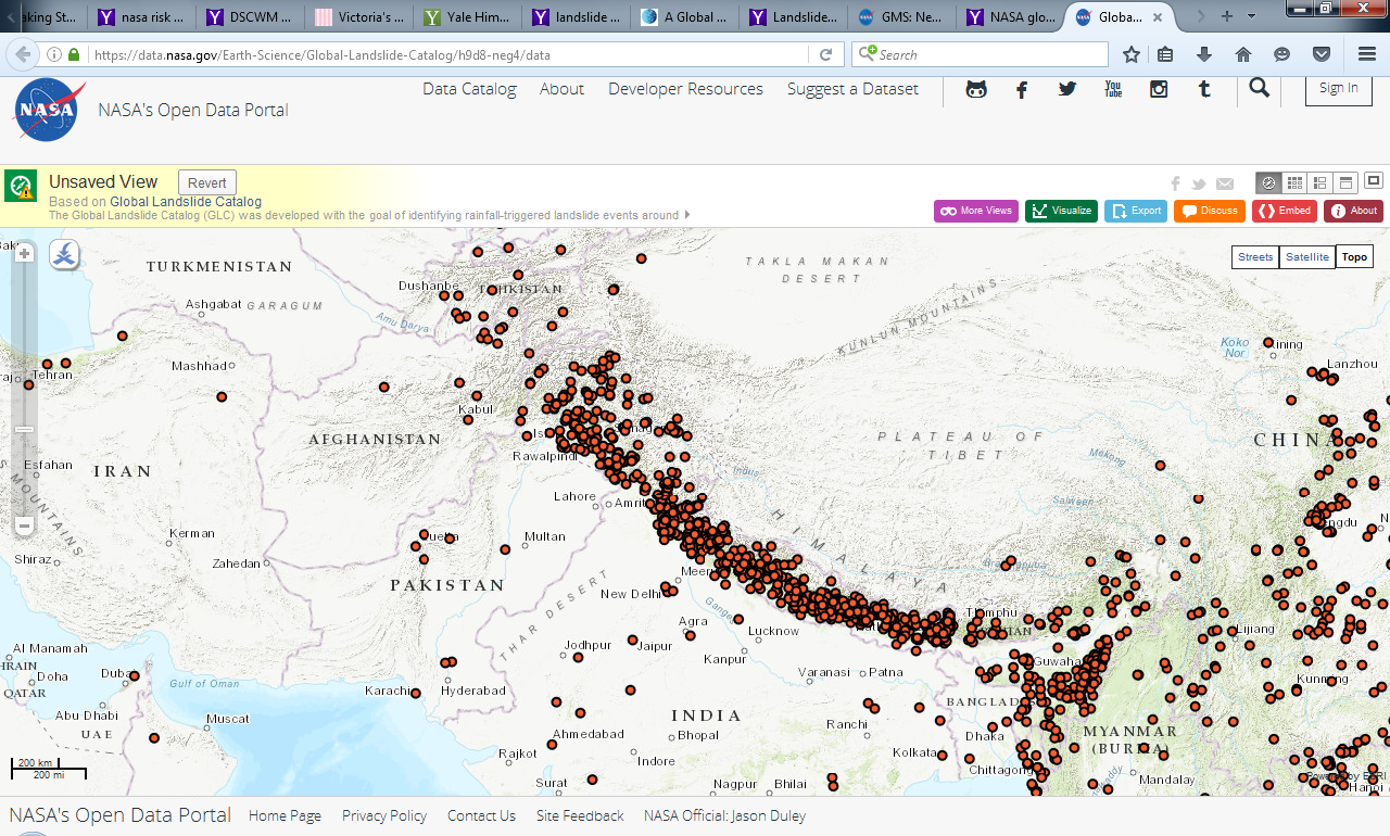 Landslide locations in the South Asia region from NASA’s Global Landslide Catalog.
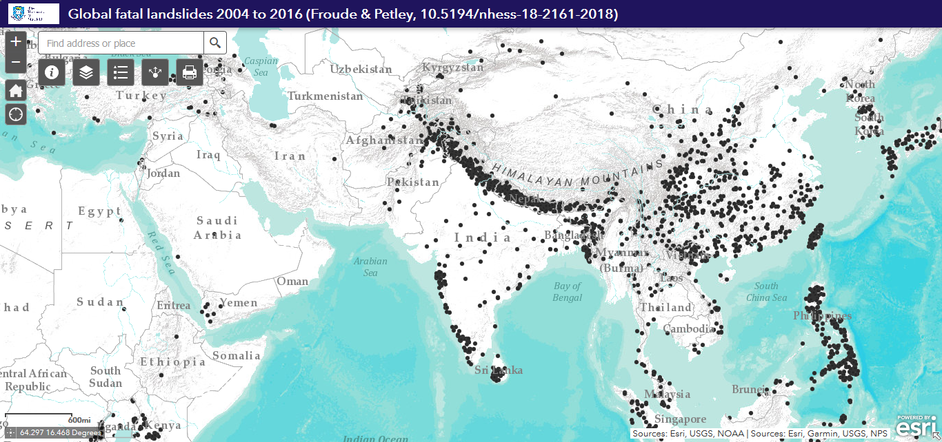 Screenshot of the Global Fatal Landslide Database tool, showing concentration of landslides in South and East Asia.